

Apache Spring Trailhead
The end of Arizona Trail Passage 4 and the start of Arizona Trail Passage 5. The Apache Spring Trailhead is easily accessible from the dirt road, Gardner Canyon Road FR92. It offers a large turnaround loop, plenty of parking for trailers and vehicles, and access to Elata Trail #162 and Kentucky Camp Connector #163.
Apache Spring Trailhead Photo Gallery


General Information
Year-round
6:00 am to 10:00 pm
No fees are required for this site
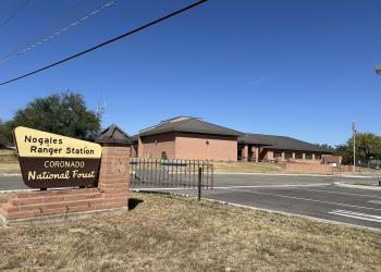
Address: 303 Old Tucson Rd. Nogales, AZ 85621
Phone: (520) 761-6000
Hours: 8:00 a.m. - 4:30 p.m. Monday-Friday (Closed on federal holidays)
Getting There
Latitude / Longitude
Latitude: 31.7201
Longitude: -110.75414
Elevation
5,229
Directions
From Sonoita, follow AZ 83 north 4 miles and turn left (west) onto Gardner Canyon Road (FR 92). Avoid side roads. You’ll reach the Apache Springs Trailhead 5.5 miles from the highway on the right side of the road. There is a large parking area here.
Facility and Amenity Information
Restrooms
Restrooms are not available at this site.
Water
Potable water is not available at this site.
Picnic Tables
Picnic tables are not available at this site.
Horse/Pack Animal Information
Horse/Pack animals are allowed at this site.
Nearby Trails
Recreation Opportunities
Recreation Groups

The first 13 passages of the Arizona National Scenic Trail pass through the Coronado National Forest.

The first 13 passages of the Arizona National Scenic Trail pass through the Coronado National Forest.

This dirt road leads to a parking area for the Arizona Trail, many primitive campsites, and the Cave Canyon and Gardner Canyon Trailheads.