
Garnet #411
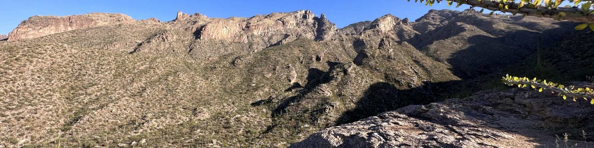
There are good views along both of these trails and plenty of evidence of mining activity left over from the days when the Santa Catalinas were the focus of extensive mineral exploration. At one time Garnet Trail, formally the Pontatoc Ridge Trail, was even called the Old Spanish Mine Trail, but don’t look for lost mines here. The reason these mines were abandoned is because they didn’t “pan out.” Do be careful around these dangerous old digs which can present several hazards for unsuspecting travelers or those too willing to take a risk. Of the two trails, the Pontatoc Trail goes up the canyon of the same name, climbing in and out of the canyon bottom as it becomes rockier and narrower. This trail presents good views of the Pontatoc Cliffs that form a deeply weathered and pockmarked face on the northeastern horizon. Extensive trampling of the area between the trailhead and Pontatoc Canyon has made it difficult to pick out the trail from all the incidental paths that have developed here, but once the trail enters the canyon it becomes easier to follow, at least for a while. Farther up in the canyon, it again becomes difficult to follow before disappearing entirely just beyond the point where it leaves the canyon floor. The Pontatoc Ridge Trail branches south of the canyon trail about 0.8 miles from the trailhead. It then climbs to the ridge top and changes direction to follow the ridge north to Pontatoc Saddle. At the saddle, you’ll be rewarded with excellent views of Tucson lying at the foot of the Catalinas and stretching toward other mountain ranges across the basin. You’ll also get a closer look at the Pontatoc Cliffs and see a trail that leads to the base of those cliffs. Take care if you follow this trail; or better yet, don’t follow it at all. It takes a steep and rocky course above a precipitous cliff. Better to enjoy the views from the more solid footing of the saddle.
Download the Pima, Finger Rock, and Ventana Canyons Trail Guide in English.
Descarga la guía de recreación en español a los cañones Pima, Finger Rock y Ventana.
From January 1st to April 30th, traveling more than 400 feet off this Forest Service system trail is prohibited due to the bighorn sheep lambing season. 36 C.F.R. § 261.53(a) No animal may be brought, or allowed to enter, into the Restricted Area at any time during the year. This prohibition includes, but is not limited to, dogs, domestic sheep, and goats.
General Information
Sunrise to sunset. Permit required for overnight parking. Visit the Pima County, AZ Trails website to obtain a free permit.
Fire Permit and Backpacking Permit ARE NOT required for this area.
Motorized equipment and equipment used for mechanical transport are prohibited. This includes the use of motor vehicles, motorboats, motorized equipment, bicycles, hang gliders, wagons, carts, portage wheels, and the landing of aircraft including helicopters, unless provided for in specific legislation.
Dogs are prohibited in the Bighorn Sheep Management Area portion of the Pusch Ridge Wilderness.
Pets are prohibited on all trails within the Bighorn Sheep Management Area of the Pusch Ridge Wilderness.

Address: 5700 N. Sabino Canyon Rd., Tucson, AZ 85750
Phone: (520) 749-8700
Hours: 8:00 a.m. - 4:30 p.m. Monday-Friday (Closed on federal holidays)
Getting There
Parking
No fee or pass required at Pima Co. trailheads. Lots fill quickly; carpool and have a backup plan if no parking is available.
Facility and Amenity Information
Restrooms
Restrooms are not available at this site.
Water
Potable water is not available at this site.
Drinking water: Drinking water is available at the trailhead, but natural sources of water must be purified before use.
Recreation Opportunities
Recreation Groups

These steep, rugged trails in the front range of the Santa Catalina Mountains offer quick access from town to trail and lead into the Pusch Ridge Wilderness.