

Mount Lemmon Trail #5
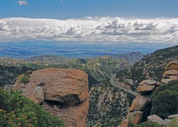
Expansive views, lots of connecting trails and access to the western portion of the Wilderness of Rock with its immense boulders and picturesque formations characterize this high country trail.
The Mount Lemmon Trail #5 starts near the summit of the 9,157-foot peak for which it is named, at a parking area about a mile past Mt. Lemmon Ski Valley near the end of Observatory Road. After following an access road along a buried powerline, it strikes off on a more backcountry course down one of the most prominent ridges that fan out from the mountaintop. Views are big here, encompassing the Wilderness of Rock to the southeast, Romero Canyon to the west and north, and most dramatic of all, Pusch Ridge to the west, stair-stepping its sawtooth course toward Tucson.
The route the Mt. Lemmon Trail follows through this rugged, mountainous country is steep and rocky in a number of places. Most notable of those difficult stretches are the series of switchbacks where the trail drops off the high ridge of the Catalinas toward the Wilderness of Rock, and the section between the Wilderness of Rock Trail #44 and West Fork Trail #24 junctions, where trail gradients are as steep as they get in the Santa Catalina Mountains.
The Mt. Lemmon Trail provides access to a number of other trails in the Pusch Ridge Wilderness, including Sutherland #6, Lemmon Rock Lookout #12, Wilderness of Rock #44, Romero #8 and West Fork #24 trails. Many who hike this trail leave a second vehicle at one of these other trailheads and use the Mt. Lemmon Trail as part of a long day trip or a segment of a multi-day backpack. Whatever option you choose, chances are good that you’ll be back to try one of the others.
Active Alerts
Specific Trail Information
Trail Number
Trail Type
Accessibility
Not an accessible trail.
General Information
5.8 miles one way
9,084 feet to 7,269 feet
Year-round
No potable water available.
Dogs are prohibited in the Bighorn Sheep Management Area portion of the Pusch Ridge Wilderness.
No animal may be brought, or allowed to enter, into the Restricted Area at any time during the year. This prohibition includes, but is not limited to, dogs, domestic sheep, and goats.
Motorized equipment and equipment used for mechanical transport are prohibited. This includes the use of motor vehicles, motorboats, motorized equipment, bicycles, hang gliders, wagons, carts, portage wheels, and the landing of aircraft including helicopters, unless provided for in specific legislation.
From January 1st to April 30th, traveling more than 400 feet off this Forest Service system trail is prohibited due to the bighorn sheep lambing season.

Address: 5700 N. Sabino Canyon Rd., Tucson, AZ 85750
Phone: (520) 749-8700
Hours: 8:00 a.m. - 4:30 p.m. Monday-Friday (Closed on federal holidays)
Getting There
Directions
Take the Catalina Highway off Tanque Verde Road in Tucson. Drive 4.2 miles to the Forest boundary and continue 28 miles, past Mt. Lemmon Ski Valley, to the power substation on Radio Ridge. Hike west on the trail to a dirt road. Hike down the road to the trail junction. The Catalina Highway is paved and suitable for passenger cars. Observatory Road is an all-weather gravel road. Both roads may be snow-covered in winter, when chains or 4-wheel drive may be required. Observatory Road beyond Mt. Lemmon Ski Valley is not maintained for public use during the winter. It is closed when snow-covered or icy.
Nearby Recreation Sites
Recreation Opportunities
Recreation Groups
SUMMERHAVEN and the SUMMIT AREA Less than one hour from downtown Tucson, perennial water, picnic areas, and a network of wooded trails offer recreation opportunities for al