-
Lower Salt River Seasonal Bald Eagle Closures
Details below.
Alert Start Date: December 1st, 2024
Alert End Date: June 30th, 2026
Order Number: 03-12-03-24-65
Associated Documents
Forest Order
IMPLEMENTATION
This Order shall be in effect from Dec. 1, 2024, at 12 p.m. and will remain in effect seasonally each year from Dec. 1 through June 30, until June 30, 2026, at 12 p.m., unless rescinded.
PURPOSE
The purpose of this Order is to provide seasonal protection of nesting bald eagles during their critical reproductive period in high-intensity recreation areas.
PROHIBITIONS
Pursuant to 16 U.S.C. § 551 and 36 C.F.R. § 261.50(a), the following is prohibited on the National Forest System (NFS) lands in the Mesa Ranger District, Tonto National Forest, described below and shown on the attached map incorporated into this Order as Exhibits A & B (the "Described Areas"):
- Going into or being upon the Described Area, which is closed for the protection of threatened, endangered, rare, unique, or vanishing species of plant, animals, birds, or fish. 36 C.F.R. § 261.53(a).
DESCRIBED AREAS
All National Forest System lands within the boundaries as depicted in Exhibits A and B, and more particularly described as follows:
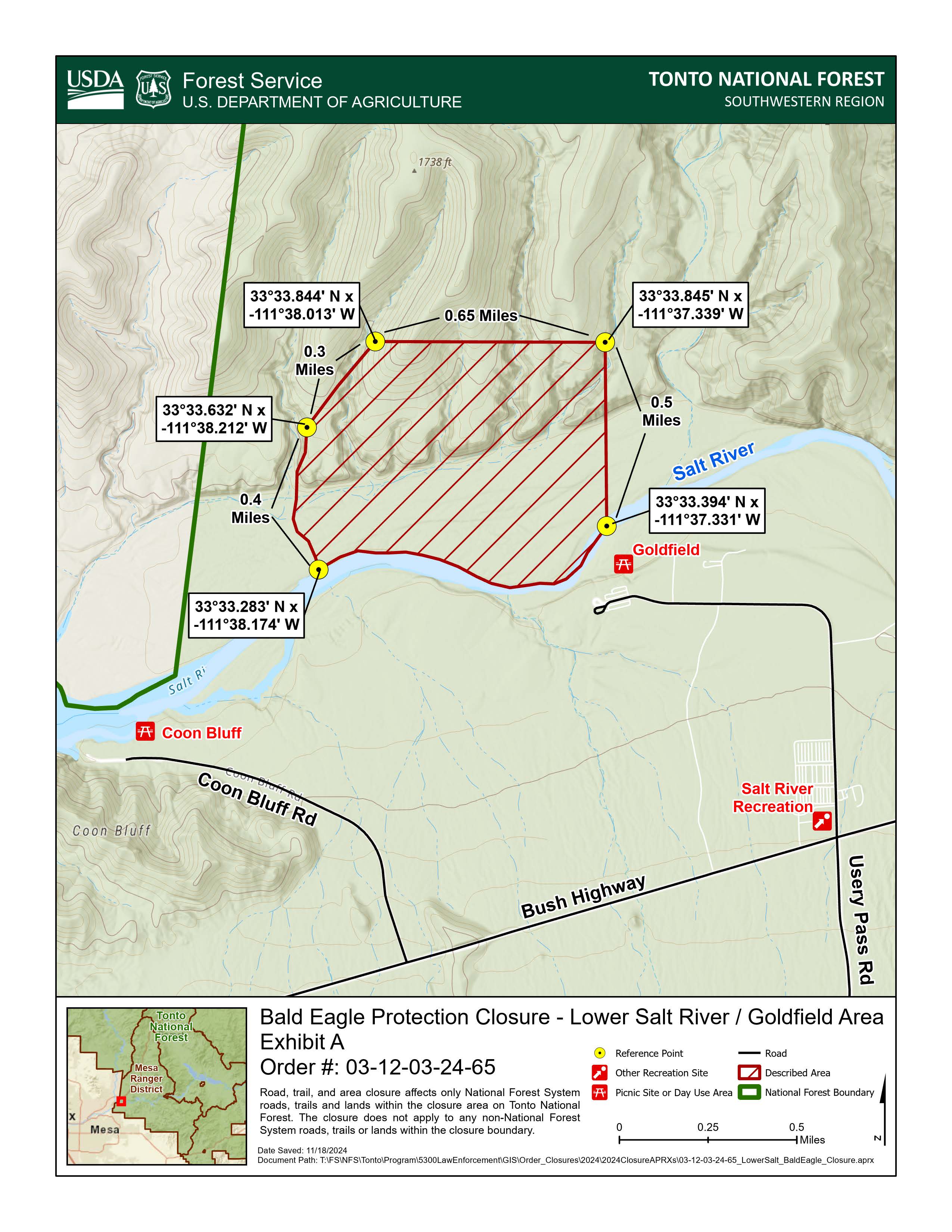
Goldfield Area (Exhibit A)
The Described Area is within Section 33 and 34, Township 3 North, Range 7 East. The Described area consists of all NFS lands within the boundary starting at the north side of the Salt River, directly across from the Goldfield Recreation Site at reference point 33°33.394' N x -111°37.331' W, then following north approximately 0.5 miles to reference point 33°33.845' N x -111°37.339' W, then following west for approximately 0.65 miles to reference point 33°33.844' N x -111°38.013' W, then following southwest for 0.3 miles to reference point 33°33.632' N x -111°38.212' W, then following generally south along the
eastern cliff edge for 0.4 miles to the north side of the Salt River at coordinates 33°33.283' N x -111°38.174' W, then following east along the north side of the Salt River for approximately 1 mile, back to the starting point at the north side of the Salt River directly across from the Goldfield Recreation site, as depicted in Exhibit A.
Bulldog Area (Exhibit B)
The Described Area is within Sections 33 and PB48, Township 3 North, Range 8 East, and Sections PB39-PB41 Township 2 North, Range 8 East, Sections PB39-PB41. The Described Area consists of all NFS lands within the boundary starting at reference point 33°33.445' N x -111°31.857' W, on the Salt River, 0.7 miles south of Stewart Mountain Dam on Saguaro Lake, then following generally southwest along the southern river bank of the Salt River approximately 1.5 miles to Unnamed Drainage 1 located at reference point 33°32.846' N x -111°33.26' W, then following generally southeast along the north side of Unnamed Drainage 1 for 1.6 miles to reference point 33°32.316' N x -111°31.823' W, then following generally north along the west side of Unnamed Drainage 2 for 2 miles back to the starting point along the Salt River, as depicted in Exhibit B.
Contact Name:
Mesa Ranger StationContact Number:
(480) 610-3300Maps
Images below will open full size in a new window.