-
Lower Salt Special Occupancy Use Order
Details below.
Alert Start Date: November 27th, 2023
Alert End Date: November 26th, 2028
Order Number: 03-12-03-23-39
Associated Documents
Forest Order
PROHIBITIONS
Pursuant to 16 U.S.C. § 551 and 36 C.F.R. § 261.50(a), the following are prohibited on the National Forest System (NFS) lands in the Mesa Ranger District, Tonto National Forest, described below and shown on the attached map incorporated into this Order as Exhibit A (the "Described Areas"):
- Being in a developed recreation site after sundown or before sunrise. 36 C.F.R. § 261.58(1).
- Camping within the Described Area. 36 C.F.R. § 261.58(e).
EXEMPTIONS
- Pursuant to 36 C.F.R. § 261.50(e), the following persons are exempt from the provisions of this Order:
Persons with Forest Service Permit No. FS-7700-48 (Permit for Use of Roads, Trails, or Areas Restricted by Regulation or Order), specifically exempting them from this Order or a written determination by a Forest Service authorized officer that a permit is not required under 36 C.F.R. § 251.50(e)(1) or (2). - Any Federal, State, or Local Officer, or member of an organized rescue or firefighting resource in the performance of an official duty.
- Persons belonging to groups with a valid and current reservation for use of seasonal camping facilities within the boundaries of the Larry Forbis Group Site, located on the Lower Salt River.
- Persons lawfully fishing in accordance with Title 17, Chapter 3 of the Arizona Revised Statutes and Title 12, Chapter 4 of the Arizona Administrative Code are exempted from prohibition #1.
- Persons entering, leaving, or floating the Salt River within the Described Areas, while participating in kayaking, canoeing or other methods of navigating down the river are exempted from prohibition #1.
DESCRIBED AREAS
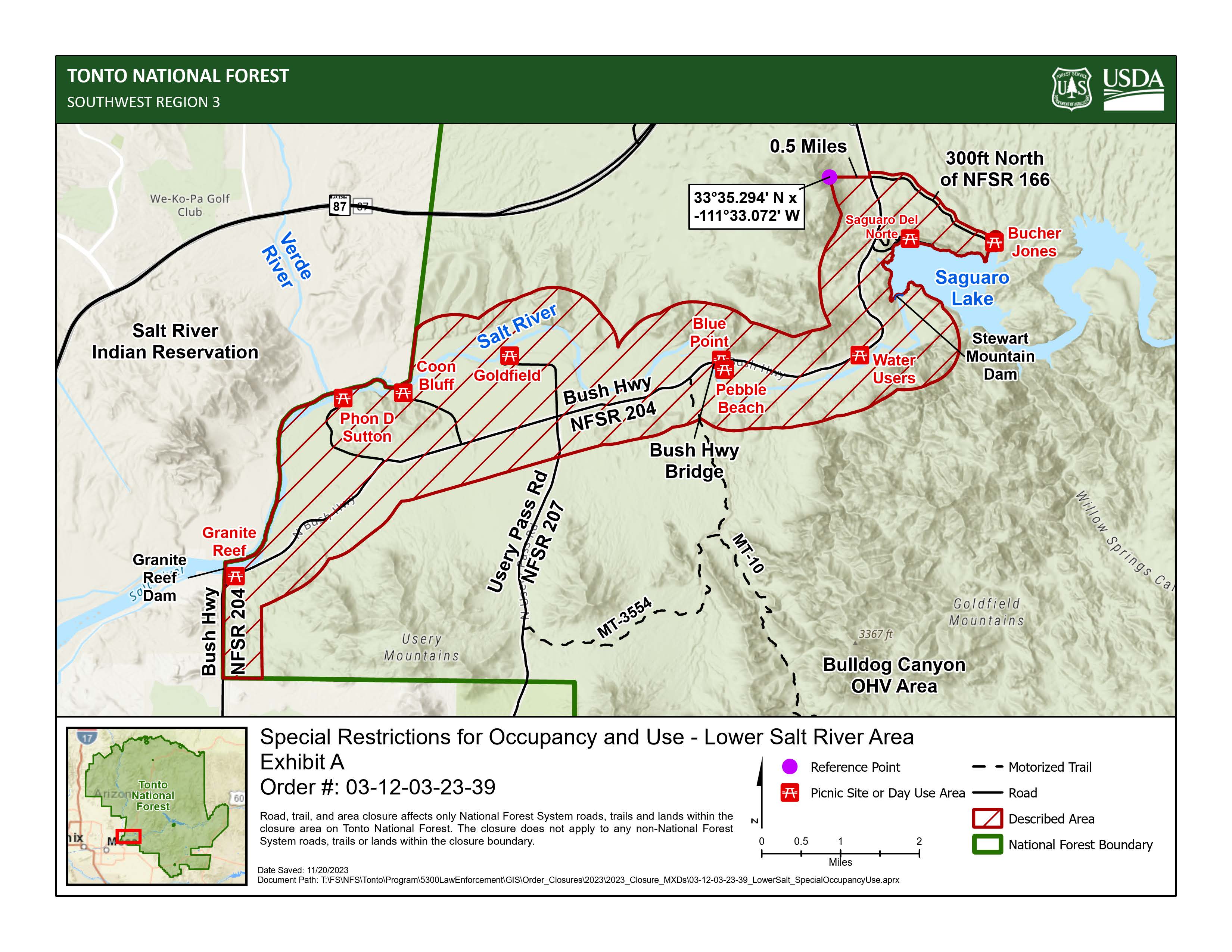
The Described Areas are within Township 2N Range 7E Sections 1-11 and 16-19, Township 2N Range BE Sections PB39-PB42, Township 3N 7E Sections 33-36, and Township 3N Range BE Sections 20-21, 28-29, and 31-33, PB44, PB47, and PB48. It consists of all National Forest System lands starting at the National Forest boundary and Bush Highway, also known as National Forest System (NFS) Road 204, then following the Forest boundary east for one half mile, then paralleling Bush Highway east and south at a distance of one half mile following North, Northeast, and East until the Bush Highway Bridge, then paralleling the Lower Salt River south and north at one half mile distance following east then north until the river reaches the Stewart Mountain Dam, then following West, North, and East along the edge of Saguaro Lake to Butcher Jones Recreation Site, then paralleling NFS Road 166 north at a distance of 300ft following North and Northwest to the intersection of NFS Road 166 and Bush Highway, then following directly west of the Bush Highway/NFS Road 166 intersection to the reference point (33° 35.294' N, -111° 33.072' W) one half mile west of Bush Highway, then paralleling Bush Highway to the west and north at a distance of one half mile following south and then west until the Bush Highway Bridge, then paralleling the Lower Salt River to the north at one half mile distance following west until the National Forest boundary with the Salt River Indian Reservation, then following the National Forest boundary south and west until the Granite Reef Dam, then following south to the point of beginning at Bush Highway and the National Forest boundary, as depicted in Exhibit A.
Prohibition #2 applies to the developed recreations sites within the Described Areas: Granite Reef, Phon D. Sutton, Coon Bluff, Goldfield, Pebble Beach, Blue Point, Water Users, Saguaro Del Norte, and Butcher Jones, as depicted in Exhibit A.
PURPOSE
The purpose of this Order is the protection of National Forest visitors and employees from unsafe conditions, the prevention of user conflicts, the conservation of natural resources, and the protection of property belonging to the United States.
IMPLEMENTATION
- This Order shall be in effect at 6:00am from November 27, 2023, through November 26, 2028 at 10:00 pm, unless rescinded.
- A map identifying the Described Areas is attached and made part of this Order as Exhibit A For a digital version of this Order and Exhibit A, go to https://www.fs.usda.gov/r03/tonto/alerts.
- Unless otherwise expressly defined in this Order, the terms used in this Order are defined by the regulations of the Secretary of Agriculture, 36. F.R. Chapter II, Parts 200-299. If there are terms in this Order that are not expressly defined in the Order or 36 C.F.R. Chapter II, Parts 200-299, their meaning shall be determined by their plain language definitions.
- A violation of the above prohibitions is punishable as a Class B misdemeanor by a fine of not more than $5,000 for individuals and $10,000 for organizations, or by imprisonment for not more than six months, or both. 16 U.S.C. § 551; 18 U.S.C. §§ 3559, 3571, and 3581.
- Contact the Mesa Ranger District in Mesa, AZ, (480) 610-3300, and Tonto National Forest Supervisor's Office in Phoenix, AZ, (602) 225-5200, for more information about this Order.
- This Order supersedes any previous Orders prohibiting the same or similar acts in the same Described Areas.
Contact Name:
Mesa Ranger StationContact Number:
(480) 610-3300Maps
Images below will open full size in a new window.