
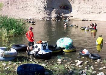
Sheeps Crossing Day Use Area
This area has covered ramadas making it ideal for large groups. The area is ideal for a day of floating leisurely down the Salt River. There are 11 Shade Ramadas with picnic tables underneath them. Grills, tables, trash, and pathways are all accessible.
General Information
Open Season: Year Round
Day use only; no overnight camping allowed
The links below provide additional information on pricing and purchasing information.
- Tonto Daily Pass (and Watercraft Sticker, if required). Available at Tonto National Forest Offices and retail vendors (please call for availability).
- Tonto Discovery Pass. Available at Tonto National Forest Offices.
- America the Beautiful Interagency Passes. Available at Tonto National Forest Offices and online at USGS.gov.
- Tonto Fee Machine Pass. Nearest locations are as follows: Pebble Beach, Saguaro Del Norte, Palo Verde, and Phon D Sutton.
Restrictions
- Day use only. No overnight camping.
- No trailers allowed
- There are no designated docks, ramps, or launch sites. No motor boats.
- Pets must be on a leash at all times
- Jumping off bridges in the area is prohibited
- Glass containers are not allowed in the Lower Salt River area
- To avoid injury wear shoes when wading in the river
- Caution: fallen trees and other materials in the river can trap swimmers and floaters
- Beware: alcohol, sun, and water are a deadly combination.
Day Use: $8/vehicle/day.
If required: Tonto Watercraft Sticker: $4/motorized watercraft.
Tonto Fee Machine Pass: $12
Tonto Forest Passes are Honored: $80/annual; $60/senior/access annual.
Address: 5140 E Ingram St, Mesa, AZ 85205
Phone: (480) 610-3300
Hours: Open Mon. - Fri. 8 a.m. - 4:30 p.m. (closed noon to 12:30 p.m.) Passes, permits and products not sold after 4 p.m. Closed Saturday and Sunday (Closed on federal holidays)
Getting There
Latitude / Longitude
Latitude: 33.55603604
Longitude: -111.5771091
Elevation
3,600 Feet
Directions
This site is located 20 miles northeast of Mesa. From Mesa, travel 7 miles east on the Superstition Freeway (US 60) to Power Road/Bush Highway/Forest Road (FR) 204 and turn north. Follow Bush Highway for 13 miles to the site just west of Blue Point Bridge. The entire route is paved.
Facility and Amenity Information
Restrooms
Restrooms are available at this site.
Water
Potable water is not available at this site.
Picnic Tables
Picnic tables are available at this site.