
Prospecting on the Caribou-Targhee National Forest
Gold mining is an important part of the history of the Caribou-Targhee National Forest, and there are several areas on the forest popular for placer gold prospecting. One of the most common prospecting methods is panning. Although gold panning does not require specific U.S. Forest Service notification or approval, you must adhere to the following rules:
- Do not dig in or alter stream banks.
- Any hand excavations should be filled as soon as possible. Open holes pose a hazard to both humans and wildlife and take longer to revegetate.
- Permission must be obtained from mining claimants before panning on claims. Mining claims are administered by the Bureau of Land Management (BLM). You can get claim information by contacting the BLM Idaho State Office at 208-373-3890 or by visiting the recorder’s office in the courthouse for the county of interest.
In general, all prospecting and mining activities which might cause a significant disturbance of surface resources must go through a review process. These activities include—but are not limited to—suction dredging (all dredge sizes), high banking, and sluicing (all sluice sizes).
A notice of intent should be submitted to the local Forest Service district ranger with the following information:
- Operator’s name and legal mailing address;
- A map or sketch sufficient to locate the proposed area of operations;
- The nature of the proposed operations, including the type of equipment to be used; and
- Access route and method of transport to the area.
If the district ranger determines the proposed operation is likely to cause a significant disturbance of surface resources, you will be notified and required to submit a plan of operations. Plan approval can take anywhere from a few months to a few years, depending on the complexity and surface disturbance of the Placer Mining on the Caribou-Targhee National Forest proposed operation. You will be required to post a reclamation performance bond before your plan is approved.
Some activities such as suction dredging and sluicing within stream channels are jointly regulated by the Idaho Department of Water Resources, the Idaho Department of Lands, the Idaho Department of Environmental Quality, and the U.S. Army Corps of Engineers. The U.S. Forest Service cannot approve plans of operations until you provide proof you have obtained the applicable permits from these agencies.
36 CFR 228.4(a) - Locatable Minerals
If you have a question about the NOI process or mining regulations, you can contact the Forest Service office that administers the lands involved with your proposed mining operation.
The purpose of submitting a Notice of Intent (NOI) for a proposed mining operation is to provide the Forest Service District Ranger with sufficient information to determine if the level of proposed disturbance will require a Plan of Operations and a detailed environmental analysis. The District Ranger will, within 15 days of receiving the NOI, evaluate it and notify the operator whether a Plan of Operations is required.
A NOI is required from any person proposing to conduct operations that might cause a significant disturbance of surface resources. If you are uncertain whether your operation falls within this category, we recommend you file a NOI. It can be included as part of a letter to the District Ranger and should address the five items listed below.
- The name, address, and telephone number of the operator. The NOI should be signed and dated by the operator.
- The area involved. The description should include the township, range, and ¼ section of where your proposal will occur and with enough detail to locate the area on the ground. We recommend you enclose a map of suitable scale (U.S. Geological Survey map scale 1: 24,000) with your NOI and indicate on the map where your operations would be located on the ground.
- The nature of the proposed operations. Describe what you plan to do. Include when and how you will be operating, the proposed start-up date, and the expected duration of the activities. List other details such as the number of people involved in the operation, equipment you intend to use (sizes, capacity, frequency of use), depth of proposed suction dredging or excavation, how waste material will be handled, what vegetation will be removed, the size of area to be disturbed, quantity of material to be removed, housing or camping facilities to be used, and the method for sewage and waste disposal.
- The route of access to the area of operations. Describe the route of access or display it on your enclosed map, and identify individual roads and trails you intend to use.
- The method of transport. Describe the vehicles or other transport used to carry people, equipment, supplies, and living quarters to and from the work site. Describe if transport will be by foot, stock (horses, mules, etc.), trucks, helicopters, motorcycles, cars, etc.
SUBJECT: Notice of Intent (NOI) for _______________
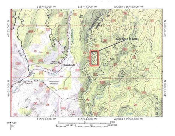
This NOI is for the subject mining claim “Lolo Gold Placer”, located on Lolo Creek, located at E ¼ NW ¼ SE ½ (29 acres) of Section 20, Township 35, Range 6 East of Boise Meridian. See Figures 1 & 2.
Image Image
Image
The recreational mining area will occur below the streambed's high-water mark. Mining activities will include panning, small unpowered sluices, and a high banker that uses a 12-volt electric powered by a battery. We use a sealed battery, so there is no danger of an acid spill. No dredging will occur. Panning and unpowered sluice activities will occur up and down Lolo Creek within the boundaries of the claim.
Image
- Access to the claim will be via the adjacent FS road known as “Lolo Creek Road” using an F350 pickup. Access to mining locations will be on foot from the road. Our equipment is small and lightweight, allowing it to be easily carried by hand.
- Our recreational mining operations will occur for seven days between July 15 and August 15, 2018. The exact dates have not been determined yet. Operations will usually not exceed 4 hours per day, as this is recreational mining, and we like hiking and doing other things. They will usually be between 1000 and 1400 hours.
- We have not decided whether to camp on the claim or stay in nearby lodging in Orofino or Pierce. We will use a tent and cat litter as our lavatory facility if we camp. The Lavatory waste will be left with us for proper disposal. All other trash will be removed from the same site and returned to its natural state.
- The owners of the subject claim will conduct recreational mining: NAME and NAME. Basic planning and unpowered sluicing will be used to search for areas within the claim boundaries that might hold a promising amount of placer gold for future high banker operations and have fun. The high banker will be operated at known promise locations as indicated in the operations figure above. All waste material (rocks, gravel, sand) used in the panning and sluicing operations will be returned to where they were removed.
- All operations will comply with all state and federal rules and regulations. No vegetation will be removed or disturbed, and the high-water mark streambanks will not be disturbed in any way. No holes, ditches, trenches, or other evidence of operations will be left. Our mode of operation will be to minimize impact within our claim to the greatest extent possible, with minimum sediment being released into the flowing stream.
- The mini-highbanker will be operated in the following manner:
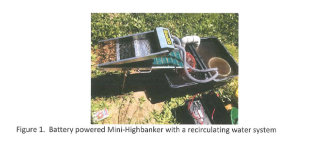
The unit will be operated on the riverbank, above the current waterline, but below the high-water mark. The mini-highbanker uses a recirculating water system that does not discharge liquid effluent into the stream. The effluent is first discharged into a 5-gallon bucket set in a large tub. The bucket catches the heavy sediment, and the water overflows into the tub for settling. The water from the tub then passes into a bucket for further settling. The pump is placed in the bucket to prevent any residual heavy sediment from being sucked in. A picture of the setup is seen in the figure below. The coarse gravel captured by the grizzly bars is pushed into a bucket below and returned to where the material originated. Since the highbanker essentially washes the gravels, no water clouding fines are introduced when the material is returned.
Image
- The water used in the mini-highbanker is collected from the stream using a 5-gallon bucket. Approximately 30 gallons of water is required to fill the system. To prevent small fish, eggs, or other floating debris from being sucked into the fill bucket, 14x14 mesh fine plastic screening is used to cover the top of the bucket.
- The mini-highbanker will be cleaned into the catch bucket using water from the recirculating system for flushing. Subsequent final concentrate panning will occur over the 5-gallon sediment bucket used to catch the mini-highbanker effluent.
- At the end of the day’s operations, the water used by the mni-highbanker, along with the collected sediment, will be poured onto the ground below the stream high water mark and as far away from the active stream flow as possible.
- Total amount of material we expect to process during a day with be <1/2 yard.


_______________________________ _______________________________
Signature Signature
WHERE TO OBTAIN MORE INFORMATION
Bureau of Land Management
Idaho State Office, Boise: 208-373-3890
Mineral & Land Records System at https://reports.blm.gov/reports/MLRS
Code of Federal Regulations
Title 36, Part 228A—Minerals (U.S. Forest Service Regulations) at https://www.ecfr.gov/
Idaho Department of Lands
Eastern Supervisory Area, Idaho Falls: 208-525-7167
Dredge and Placer Mining at https://www.idl.idaho.gov/mining-minerals/dredge-placer-mining/
Idaho Department of Water Resources
Eastern Regional Office, Idaho Falls: 208-525-7161
Recreational Mining Permits at https://idwr.idaho.gov/streams/recreational-mining-permits/
Idaho Department of Environmental Quality
Idaho Pollutant Discharge Elimination System (IPDES) Permit Authorizations: 208-373-0173
https://www.deq.idaho.gov/permits/water-quality-permits-certifications/municipal-and-industrial-permits/
For more information about prospecting and mining on the Caribou-Targhee National Forest, contact:
U.S. Forest Service Geologist
Caribou-Targhee National Forest
208-516-6297
For specific information about Caribou Basin and McCoy Creek, call 208-547-4356.