-
Area, Road, and Trail Closures (SPRING MOUNTAINS NATIONAL RECREATION AREA)
A few of the most popular roads, trails, and developed recreation sites in Deer Creek, Kyle, and Lee Canyons on the Spring Mountains National Recreation Area sustained severe damage during Tropical Storm Hillary and are unsafe to use. They still need significant work to make them fully accessible to the public and will remain closed indefinitely under a Forest Closure Order. These sites include...
- Deer Creek Road (Nevada State Routes 158): Deer Creek Picnic Area
- Kyle Canyon (Nevada State Routes 157): Mary Jane Falls and Trail Canyon Trailheads and Trails*, a portion of the Cathedral Rock Trail*, Echo Road* and Powerline Access Road
- Lee Canyon (Nevada State Routes 156): Upper Bristlecone Trailhead and Trail, a portion of Mack's Canyon Road
- *Upper Kyle Canyon Complex
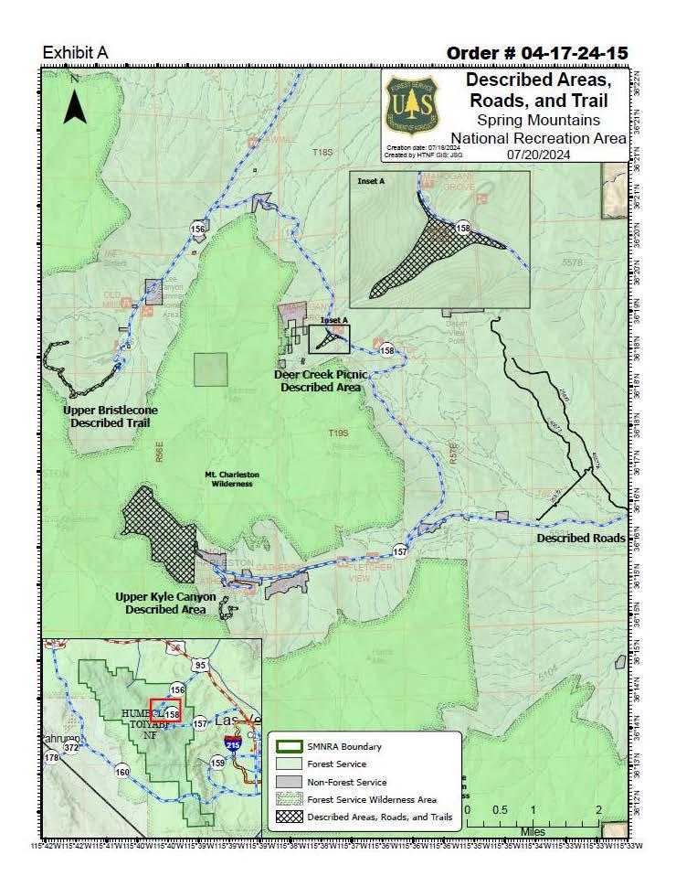
For a map that shows the closed areas, please visit Spring Mountains National Recreation Area Closure Map.
The Forest Service and partners are working hard to reduce some of the area closures caused by Tropical Storm Hilary on the Spring Mountains National Recreation Area throughout the summer. As sections of closed areas reopen, they will be announced on the Go Mt. Charleston’s web page at http://www.gomtcharleston.com and posted at https://www.facebook.com/GoMtCharleston or https://twitter.com/GoMtCharleston.
Alert Start Date: April 22nd, 2024
Alert End Date: N/A
Order Number: 04-17-24-15
Associated Documents
Forest Order
U.S. Department of Agriculture, U.S. Forest Service
Humboldt-Toiyabe National Forest
Spring Mountains National Recreation Area
Area, Road, and Trail Closures
PROHIBITIONS
Pursuant to 16 U.S.C. § 551 and 36 C.F.R. § 261.50(b), the following is prohibited on the National Forest System (NFS) lands, roads, and trail in the Spring Mountains National Recreation Area, Humboldt-Toiyabe National Forest, described below and shown on the attached map incorporated into this Order as Exhibit A (the “Described Areas,” “Described Roads,” and “Described Trails”):
- Going into or being upon the Described Areas. 36 C.F.R. § 261.53(e).
- Being on the Described Roads. 36 C.F.R. § 261.54(e).
- Being on the Described Trail. 36 C.F.R. § 261.55(a).
EXEMPTIONS
Pursuant to 36 C.F.R. § 261.50(e), the following persons are exempt from this Order:
- Authorized Federal and State personnel conducting repair work on the Described Road in the course of their official duties.
- Lee Canyon Ski Resort personnel conducting activities by their special use permit and associated operating plans, within the Upper Bristlecone Described Trail.
- Persons with Forest Service Permit No. FS-7700-48 (Permit for Use of Roads, Trails, or Areas Restricted by Regulation or Order), specifically exempting them from this Order or a written determination by a Forest Service authorized officer that a permit is not required under 36 C.F.R. § 251.50(e)(1) or (2).
- Any Federal, State, or Local Officer, or member of an organized rescue or firefighting force in the performance of an official duty.
DESCRIBED AREAS, ROADS, AND TRAIL
The Upper Bristlecone Described Trail in the entirety of the Upper Bristlecone Trail, which is in Sections 9-10, 15-16, Township 19 South, Range 56 East, Mt. Diablo Meridian, and all NFS lands within 100 feet on either side of Described Trail.
The Deer Creek Picnic Area Described Area (Inset A) is the NFS lands within Sections 7-8, Township 19 South, Range 57 East, Mt. Diablo Meridian, followed within SR 158, NFS Roads 45068, and 45068A.
The Upper Kyle Canyon Described Area is the NFS lands bounded by the Mt. Charleston Wilderness Area boundary and the North to South running section of Echo Road, and in Sections 22-23, 25-27;35-36, Township 19 South, Range 56 East, Mt.
Diablo Meridian.
The Described Roads are NFS Roads 45577, 45577A, 25872, and 25873.
PURPOSE
The purpose of this Order is to protect public safety while repair work is being conducted in the Described Areas and on the Described Roads and Trail.
IMPLEMENTATION
- This Order shall be in effect from July 20th, 2024 at 12:00 a.m. through July 20th, 2026 at 12:00 a.m., unless rescinded.
- A map identifying the Described Road is attached and made part of this Order as Exhibit A. For a digital version of this Order and Exhibit A, go to https://www.fs.usda.gov/alerts/htnf/alerts-notices.
- Unless otherwise expressly defined in this Order, the terms used in this Order are defined by the regulations of the Secretary of Agriculture, 36 C.F.R. Chapter II, Parts 200-299. If there are terms in this Order that are not expressly defined in the Order or 36 C.F.R. Chapter II, Parts 200-299, their meaning shall be determined by their plain language definitions.
A violation of the above prohibitions is punishable as a Class B misdemeanor by a fine of not more than $5,000 for individuals and $10,000 for organizations, or by imprisonment for not more than six months, or both. 16 U.S.C. § 551; 18
U.S.C. §§ 3559, 3571, and 3581.
- Contact the Spring Mountains National Recreation Area at 4701 North Torrey Pines Dr. Las Vegas, NV 89130 (702) 872-5486, and the Humboldt-Toiyabe National Forest Supervisor's Office at 1200 Franklin Way, Sparks NV 89431 (715) 331-6444, for more information about this Order.
- This Order supersedes Order #04-17-24-07.
Signed and issued on July 22nd, 2024.
/s/Jon M. Stansfield
Jon Stansfield
Forest Supervisor
Humboldt-Toiyabe National Forest
Contact Name:
Humboldt-Toiyabe National Forest Supervisor's Office at 1200 Franklin Way, Sparks NV 89431Contact Number:
(715) 331-6444Maps
Images below will open full size in a new window.