
Making a Map for Your Special Use Area
You may be asked to provide a map of your Special Use Authorization location. Simple maps can be completed using the online Forest Interactive Visitor Map.
1. Navigate to the Interactive Visitor Map (IVM)
2. Zoom in to the location you wish to map. This might be a trailhead, campsite, or section of river.
3. Select an appropriate basemap. Click the gear icon in the top middle of the screen. On the lefthand side you’ll see an icon for basemaps. Click here and choose your desired basemap.
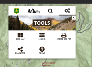
World Topo and USGS Topo are both good options. The default basemap is Streets, which is also acceptable.
The next step is to save a copy of your map. There are multiple ways to do this.
Option A: Snipping Tool
4. Use the snipping tool to take a picture of your map. PCs have a snipping tool that let you “take a snip” of a square of your screen. Use this function to take an image of the relevant section of map.
5. Markup your map. Using the pen function on the snipping tool to draw a line along the relevant trails or roads or circle the general relevant area.

6. Copy and paste the snip into a word document or email and proceed with Step 7.
Option B: PDF
4. Create the PDF of your map
Click “Create Geo PDF” in the same menu where you found the basemap options. This will most likely open a map in a new tab; however, this may depend on your browser setting. Note that this could take several minutes to load depending on your computer and internet connection.
5. Save the map to your computer. You may use a “save,” “save as,” or “print to PDF” function, depending on your preference.
6. Markup the map.
If you have the software capabilities, draw on the map to indicate the relevant area(s) using a pen or highlighter tool. You can trace the line or a trail or circle a relevant area.
If you don’t have the option to markup the map using a pen tool, describe the relevant map locations in an email. Attach the map PDF in an email to your permit administrator. In the body of the email, type something like,
“Hiking trips will be from Lovers Camp trailhead to Lovers Camp Campground,” from the above example, or
“Hunting trips will begin in the southwest quadrant of the attached map, and involve the northwest and southeast quadrants, depending on where game is tracked,” when you use a general location rather than a trailhead.
7. Repeat as necessary if you use multiple sections of forest.
8. Send to your permit administrator with your other paperwork.