
Wilderness
Wilderness Areas
The Klamath National Forest manages parts of four different Wilderness areas. The following will take you to further information about these areas.
Wilderness areas on the Klamath National Forest

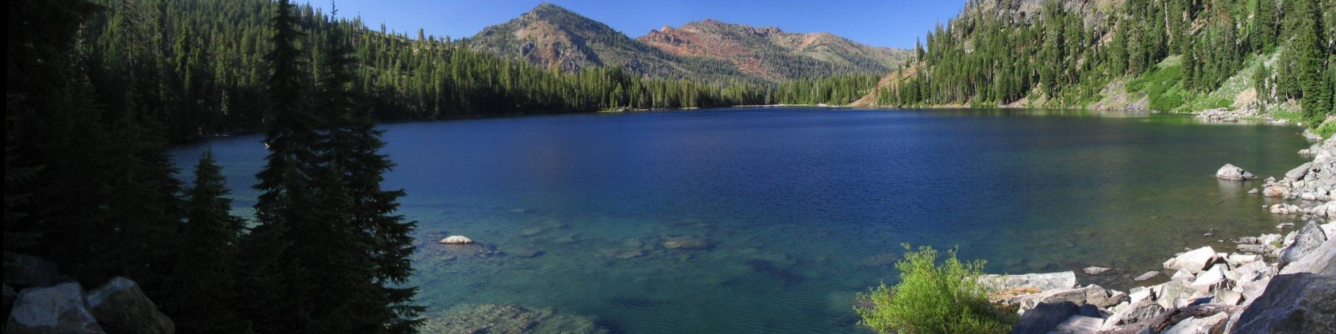
The Marble Mountain Wilderness has been recognized for its wild values for generations. This area was originally designated as a Primitive area in 1931 and is one of the original Wilderness Areas designated by the 1964 Wilderness Act.
Craggy peaks, deep canyons cloaked in conifer forests, abundant meadows, Wild and Scenic River segments, and 89 lakes highlight this 225,000-acre area. Many of the peaks exceed 6,000 feet in elevation, with Boulder Peak the highest at 8,299 feet. There are also fascinating geological features, including Marble Mountain, a stark, red-and-gray marbled peak. Here one can travel through old growth conifer forests with diverse species: low and mid-elevation species include Douglas fir, sugar pine, and white fir; higher elevation species include Shasta fir, whitebark pine, foxtail pine, and mountain hemlock. You will find alpine meadows, lakes in glacial cirques, and bare rock at higher elevations. Black bear, black-tailed deer, and many other species of wildlife inhabit this Wilderness.
Numerous trailheads and an extensive trail network provide access to the Wilderness, offering both day hikes to lakes and longer multi-day loop trips. The Pacific Crest Trail also crosses the crest of the Marble Mountains for 32 miles from south to north.
Marble Mountain Wilderness-Permits and Regulations
Wilderness Permits are not required for trips into the Marble Mountain Wilderness.
A California Campfire Permit is required if you use either a stove or a fire and is available at any Forest Service or Cal-Fire office in California, as well as online.
Travel in wilderness is restricted to on foot, on horseback, on skis or snowshoes, or in paddle rafts/kayaks. All means of mechanized transport are prohibited in wilderness except for wheelchairs needed by mobility impaired persons.
Marble Mountain Wilderness Trails on the Klamath National Forest
There are over 600 miles of trails in the “Marbles” ranging from well-maintained routes like the Pacific Crest National Scenic Trail (PCT) to steep little-used paths. Trail signs in wilderness areas are intentionally kept to a minimum to enhance the wilderness experience, so a good topographical map is a must.
Forest Service maintenance of the trail system depends on several factors: more developed trails are maintained more often; whether the trail leads to a popular destination; whether a trail is in are area recently burned by wildfire; whether there is available funds for trail crews; and the efforts of partners and volunteers. On some trails, especially early in the season, you may be forced to make detours around fallen trees and other obstacles.
Let'er Buck Trailhead
- Let'er Buck Trail
- Intersecting Trails
- Haypress Trail
Haypress Trailhead
- Haypress Trail
- Intersecting Trails
- Let’er Buck Trail
- Bridge Creek Trail
- McCash Loop Trail
- Secret Lake Trail
- Ukonom/Cuddihy Lakes Trail
Stanshaw Meadow Trailhead
- Stanshaw Meadow Trail
- Intersecting Trails
- Ten Bear Trail
- McCash Loop Trail
- Haypress Trail
Ten Bear Trailhead
- Ten Bear Trail
- Intersecting Trails
- Stanshaw Trail
Johnson’s Hunting Ground Trailhead
- Johnson’s Hunting Ground Trail
- Intersecting Trails
- Tickner Creek Trail
- Ukonom/Cuddihy Lakes Trail
Norcross Trailhead
- Elk Creek Trail
- Lower Bear Lake Trail
- Intersecting Trails
- Granite Creek Trail
- Rainy Valley Creek Trail
- Marble Mountain Gap Trail
- Pigeon Roost Trail
Bear Lake Trailhead
- Bear Lake Trail
- Intersecting Trails
- Pacific Crest Trail
Cold Springs/Huckleberry Mtn. Trailhead
- Pacific Crest Trail (Big Ridge Trail)
- Intersecting Trails
- Tyler Meadows Trail
- Bear Lake Trail
Tyler Meadows Trailhead
- Tyler Meadows Trail
- Intersecting Trails
- Kelsey Creek Trail
- Pacific Crest Trail
- Bear Lake Trail
Kelsey Trailhead
- Kelsey Creek Trail
- Intersecting Trails
- Pacific Crest Trail
- Paradise Lake Trail
Paradise Lake Trailhead
- Paradise Lake Trail
- Intersecting Trails
- Pacific Crest Trail
- Kelsey Creek Trail
Box Camp Trailhead
- Box Camp Trail
- Intersecting Trails
- Pacific Crest Trail
Lover’s Camp Trailhead
- Canyon Creek Trail
- Intersecting Trails
- Red Rock Trail
- Deep/Wright Lakes Trail
- Pacific Crest Trail
- Little Elk Lake Trail
- Sky High Lake Trail
- Cold Springs Camp Trail
Boulder Creek Trailhead
- Boulder Creek Trail
- Intersecting Trails
- Deep/Wright Lakes Trail
- Red Rock Trail
Big Meadows Trailhead
- Big Meadows Trail
- Intersecting Trails
- Calf/Long High Lake Trail
- Wrights Lake Trail
Shackleford Trailhead
- Shackleford Trail
- Intersecting Trails
- Cliff Lake/Campbell Lake Trails
- Calf Lake/Long High Lake Trail
- Pacific Crest Trail
Mill Creek Ponds Trailhead
- Mill Creek Ponds Trail
Etna Mill Creek Trailhead
- Etna Mill Creek Trail
- Intersecting Trails
- Pacific Crest Trail
Etna Summit Trailhead
- Pacific Crest Trail
Mulebridge Trailhead
- North Fork Trail
- Intersecting Trails
- Right Hand Fork Trail
- Bug Gulch Trail
- Lake of the Island Trail
- Abbot Lake Trail
- Horse Range Trail
Little North Fork Trailhead
- Little North Fork Trail
- Intersecting Trails
- Garden Gulch Trail
- Devil’s Canyon Trail
- English Peak Trail
- Pine Lake Trail
- Wild Lake Trail
- Ethel Lake Trail
Garden Gulch Trailhead
- Garden Gulch Trail
- Intersecting Trails
- Portuguese Peak Trail
- Little North Fork Trail
Portuguese Peak Trailhead
- Portuguese Peak Trail
- Bug Gulch Trail
- Intersecting Trails
- Garden Gulch Trail
Wooley Creek Trailhead
- Wooley Creek Trail
- Intersecting Trails
- Bridge Creek Trail
- Big Meadows Trail
The Russian Wilderness is located 7 miles southwest of Etna, California. Information about this wilderness can be found at wilderness.net, a website jointly managed by the University of Montana and the four federal agencies that manage designated wilderness areas.
Russian Wilderness-Regulations and Permits
The wilderness.net website lists current regulations for this wilderness.
Wilderness permits are not required for trips into the Russian Wilderness. A California Campfire Permit is required and is available from any Forest Service or Cal-Fire office in California, as well as online.
Russian Wilderness Safety
- Wilderness, by its very nature, has inherent risks. Help may be hours or even days away. You may not be able to rely on a cellphone for communication. Remember, wilderness safety is YOUR responsibility.
- A few tips to remember when planning your wilderness trip, as well as some things to keep in mind while on your hike.
- Always leave an itinerary of your hike with family or friends, and stick to it.
- Before your trip, learn about the hazards you may encounter and take adequate precautions. Select appropriate clothing and equipment. Always hike with a companion. Choose a trail that matches the skill level of your party.
- Know your own limitations, and the abilities and weaknesses of your hiking companions. Plan your route and rate of travel around the weakest member. Make sure that each member of your party knows what gear the others have packed.
- Track your location using map and compass or GPS. If you encounter trouble, do not be afraid to turn back. Wilderness maps are available online at the U.S. Geological Survey Store and at all Klamath National Forest Offices.
Russian Wilderness Trails on the Klamath National Forest
There are nearly 100 miles of trails in the Russian Wilderness. Some of these trails are steep, little-used paths, while others are well-maintained routes. The amount of maintenance depends on the use patterns, wilderness preservation objectives, available funds and volunteers. On some trails, don’t be surprised if you are forced to make some detours around logs and other obstacles throughout the year. Trail signs in wilderness areas are intentionally kept to a minimum to enhance the wilderness experience, so a good topographical map is a must. Wilderness maps are available online at the U.S. Geological Survey Store and at all Klamath National Forest Offices.
Etna Summit-PCT Trailhead
- Pacific Crest Trail
- Intersecting Trails
- Ruffey/Meeks Meadow/Smith Lake Trail
- Paynes Lake Trail
Paynes Lake Trailhead
- Paynes Lake Trail
- Intersecting Trails
- Pacific Crest Trail
Duck/Eaton Lake Trailhead
- Duck Lake Trail
- Eaton Lake Trail
- Intersecting Trails
- Music Creek Trail
- Horseshoe Lake Trail
- Lipstick Lake Trail
Bingham Lake Trailhead
- Bingham Lake
Deacon Lee Trailhead
- Water Dog/Russian Lake Trail
- Intersecting Trails
- South Russian Trail
South Russian Trailhead
- South Russian Trail
- Intersecting Trails
- Deacon Lee Trail
Music Creek Trailhead
- Music Creek Trail
- Intersecting Trails
- Pacific Crest Trail
- Lipstick Lake Trail
- Duck Lake Trail
Taylor Lake Trailhead
- Taylor Lake Trail
- Intersecting Trails
- Hogan Lake Trail
The Siskiyou Wilderness is located 10 miles north of Happy Camp, California. The Siskiyou Wilderness is cooperatively managed by three National Forests: the Six Rivers, Klamath and Rogue River-Siskiyou. Information about this wilderness can be found at wilderness.net, a website jointly managed by the University of Montana and the four federal agencies that manage Wilderness.
Siskiyou Wilderness-Regulations and Permits
The wilderness.net website lists the current regulations for this wilderness.
Wilderness permits are not required for trips into the Siskiyou Wilderness. A California Campfire Permit is required and can be obtained at any Forest Service or CAL FIRE office in California.
Siskiyou Wilderness Safety
Wilderness, by its very nature, has inherent risks. Help may be hours or even days away. You may not be able to rely on a cell phone for communication. Remember, wilderness safety is YOUR responsibility.
A few tips to remember when planning your wilderness trip, as well as some of the things to keep in mind while on your hike:
- Always leave an itinerary of your hike with family or friends, and stick to it.
- Before your trip learn about the hazards you may encounter and take adequate precautions. Select appropriate clothing and equipment. Always hike with a companion. Choose a trail that matches the skill level of your party.
- Know your own limitations, and the abilities and weaknesses of your hiking companions. Plan your route and rate of travel around the weakest member. Make sure that each member of your party knows what gear the others have packed.
- Track your location using map and compass or GPS. If you encounter trouble, do not be afraid to turn back. Wilderness maps are available online at the U.S. Geological Survey Store or some of these Klamath National Forest Offices.
- During bad weather like rain, snow, and fog, you may be safer if you stay put rather than attempt to travel.
- Bring a good first aid kit with adequate supplies for your party size and type. Know basic first aid skills.
- Know how to identify Poison Oak and stay away from it.
- If you encounter a rattlesnake, avoid it by traveling at least two body lengths away from it. Never attempt to kill a rattlesnake, as this would increase your danger of being bitten.
- Filter or treat all water used for drinking.
Siskiyou Wilderness Trails on the Klamath National Forest
The Siskiyou Wilderness contains many lower elevation settings that can be accessed for recreation year round, providing opportunities typically not available elsewhere. There are over 100 miles of trails in the Siskiyou Wilderness. Some of these trails are steep, little used paths, while others are well maintained routes. The amount of maintenance depends on the use patterns, wilderness preservation objectives, available funds, and volunteers. On some trails, don't be surprised if you are forced to make some detours around logs and other obstacles throughout the year. Trail signs in wilderness areas are intentionally kept to a minimum to enhance the wilderness experience, so a good topographical map is a must. Wilderness maps are available online at the U.S. Geological Survey Store or at some of these Klamath National Forest offices.
Doe Flat Trailhead
- Doe Flat Trail
- Intersecting Trails
- Devil’s Punchbowl Trail
- Clear Creek National Recreation Trail
Young’s Peak Trailhead
- Young’s Valley Trail
- Intersecting Trails
- Clear Creek National Recreation Trail
- Poker Flat Trail
- Raspberry Lake Trail
- East Fort Illinois River Trail (on Wild Rivers District of Rogue/Siskiyou NF)
Poker Flat Trailhead
- Poker Flat Trail
- Intersecting Trails
- Young’s Valley Trail
- Kelly Lake-Poker Flat Trail
- Raspberry Lake Trail
- Black Butte Trail (on Wild Rivers District of Rogue/Siskiyou NF)
Kelly Lake Trailhead
- Kelly Lake
- Poker Flat Trail
No Mans Trailhead
- Clear Creek National Recreation Trail
- Intersecting Trails
- West Fork Clear Creek Trail
Elbow Springs Trailhead
- Kelsey National Recreation Trail
- Intersecting Trails
- West Fork Clear Creek Trail
Dillon Creek Campground
- Dillon Creek Trail
- Intersecting Trails
- West Fork Clear Creek Trail
The Trinity Alps Wilderness on the Klamath National is located about 6 miles South of Callahan, California. Management of the Wilderness is shared by the Klamath National Forest, Shasta-Trinity National Forest, and Six Rivers National Forest. Information about this wilderness can be found at wilderness.net, a website jointly managed by the University of Montana and the four federal agencies that manage designated wilderness areas.
Trinity Alps Wilderness-Regulations and Permits
Wilderness managers often need to take action to limit the impacts caused by visitor activities in order to protect the natural conditions of the wilderness as required by the Wilderness Act of 1964. Managers typically implement 'indirect' types of actions such as information and education measures before selecting more restrictive measures. When regulations are necessary, they are implemented with the specific intent of balancing the need to preserve the character of the wilderness while providing for the use and enjoyment of wilderness area. The wilderness.net website lists the current regulations for this wilderness.
No more than 10 individuals are permitted to camp or hike together in each group in the Trinity Alps Wilderness.
Wilderness Permits and California State Campfire Permits are required for trips into this wilderness. Self-issued Wilderness Permits are available 24 hours a day at the Salmon River/Scott River Ranger District office, Weaverville Ranger District office, Coffee Creek Guard Station, and Callahan Guard Station. California State Campfire Permits are available at any Forest Service or Cal-Fire office in California, as well as online.
Trinity Alps Wilderness Safety
Wilderness, by its very nature, has inherent risks. Help may be hours or even days away. You may not be able to rely on a cell phone for communication. Remember, wilderness safety is YOUR responsibility.
A few tips to remember when planning your wilderness trip, as well as some things to keep in mind while on your hike:
- Always leave an itinerary of your hike with family or friends, and stick to it.
- Before your trip, learn about the hazards you may encounter and take adequate precautions. Select appropriate clothing and equipment. Always hike with a companion. Choose a trail that matches the skill level of your party.
- Know your own limitations, and the abilities and weaknesses of your hiking companions. Plan your route and rate of travel around the weakest member. Make sure that each member of your party knows what gear the others have packed.
- Track your location using map and compass or GPS. If you encounter trouble, do not be afraid to turn back. Wilderness maps are available online at the U.S. Geological Survey Store and at Klamath National Forest offices.
- During bad weather like rain, snow, and fog, you may be safer if you stay put rather than attempting to travel.
- Bring a good first aid kit with adequate supplies for your party size and type. Know basic first aid skills.
- Know how to identify Poison Oak and stay away from it.
- If you encounter a rattlesnake, avoid it by traveling at least two body lengths away from it. Never attempt to kill a rattlesnake, as this would increase your danger of being bitten.
- Filter or treat all water used for drinking.
Trinity Alps Wilderness Trails on the Klamath National Forest
There are about 550 miles of trails in the Trinity Alps Wilderness. Some of these trails are steep, little used paths, while others are well maintained routes. The amount of maintenance depends on the use patterns, wilderness preservation objectives, available funds, and volunteers. On some trails, don't be surprised if you are forced to make some detours around logs and other obstacles throughout the year. Trail signs in wilderness areas are intentionally kept to a minimum to enhance the wilderness experience, so a good topographical map is a must. Wilderness maps are available online at the U.S. Geological Survey Store and at Klamath National Forest offices.
Cecil Lake Trailhead
- Chilkott Trail
- Hull Cabin Trail
- Intersecting Trails
- Salmon Summit Trail
- Spring Trail
China Gulch Trailhead
- China Spring Trail
- Intersecting Trails
- North Fork Trail
Garden Gulch Trailhead
- Onion Meadow Trail
- Intersecting Trails
- Packers Peak Trail
South Fork Trailhead
- Rush Creek Trail
- South Fort Trail
- Intersecting Trails
- McNeal Creek Trail
- Packers Peak Trail
- Little South Fork Trail
Poison Creek Trailhead
- Poison Trail
- Intersecting Trails
- Packers Peak Trail
- Onion Meadow Trail
Fish Lake Trailhead
- Fish Lake Creek Trail
- Intersecting Trails
- Twin Lakes Trail
- South Fork Coffee Creek Trail
- Trail Gulch Trail
- Onion Meadow Trail
- Packers Peak Trail
Long Gulch Trailhead
- Long Gulch Trail
- Intersecting Trails
- Twin Lakes Trail
- South Fork Coffee Creek Trail
- Trail Gulch Trail
- Onion Meadow Trail
- Packers Peak Trail
Trail Gulch Trailhead
- Trail Gulch Trail
- Intersecting Trails
- North Fork Coffee Creek Trail
- Steveale Creek Trail
- Long Gulch Trial
Carter Meadows Summit Trailhead
- Pacific Crest Trial
- Intersecting Trails
- South Fork Ridge Trail
- Hidden Lake Trail
Fox Creek Ridge Trailhead
- Fox Creek Ridge Trail
- Intersecting Trails
- Fox Creek Lake Trail
- Wolford Cabin Trail
- Pacific Crest Trail
Middle Boulder Trailhead
- Middle Boulder Lake Trail
- Intersecting Trails
- Telephone Lake Trail
- Pacific Crest Trail
- Boulder Tie Trail
East Boulder Trailhead
- East Boulder Trail
- Intersecting Trails
- Little Mill Trail
- Boulder Tie Trail
- Pacific Crest Trail
Little Mill Trailhead
- Little Mill Trail
- Intersecting Trails
- East Boulder Trail
Caribou Lakes Trailhead
- Caribou Lakes Trail
- Tri-Forest Trail
- Caribou Gulch Trail
- South Fork Trail
High Point Trailhead
- Salmon Summit Trail
- Intersecting Trails
- East Boulder Trail
Hotelling Trailhead
- Hotelling Trail
- Intersecting Trails
- Salmon Summit Trail