
Campground: Walupt Lake
A popular high elevation campground on the shores of Walupt Lake and surrounded by the Goat Rocks Wilderness. The campground offers various sizes of camping units as well as 7 walk-in sites.
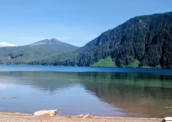
Walupt Lake spans 384 acres and is the second largest lake in the Gifford Pinchot National Forest. The clear mountain waters are popular with anglers who come here to cast for Rainbow and Cutthroat Trout. Scattered throughout the area are alpine meadows, lakes and ponds.
The Lake has a primitive boat ramp and Day Use area great for swimming and hanging out a hot summer day. Mosquitos can be a problem early in the season. There are numerous trails nearby. Walupt Lake Trail # 101 goes along the northern edge of the lake and is an easy hike to the end of the lake. The Nanny Ridge Trail # 98 climbs steeply but offers great views of the Goat Rocks Wilderness.
Walupt Lake Day Use Picnic Site is within this campground.
View a Walupt Lake Campground map (PDF)
Walupt Lake
Generally, only accessible by vehicle Late May to late October.


Reservations
Make Reservations HereReservations can be made online at recreation.gov or by calling 1-877-444-6777.
General Information
The Forest Service does not manage campground during summer season. Concessionaire Operations generally commence Late June or Early July until September. For more information about the concessionaire please visit ExplorUS .
Mid July - Mid September
Check in: 2:00 p.m.; Check-out: 12:00 p.m.; Quiet hours are 10:00 p.m. until 6:00 a.m.
50% discount for single site camping fee with any of these passes: Interagency Senior, Interagency Access, Golden Age, or Golden Access.
Restrictions:
- No campfires
- Maximum vehicle length is 22 feet.
- 10 m.p.h. speed limit on Walupt Lake.
- Wilderness Regulations apply within Goat Rocks Wilderness. Permits are required within Goat Rocks Wilderness. The self-issuing permits are free and available at trailheads.
- Those without reservations are prohibited from taking over a reserved campground and must contact camp host to for next available site.
- Paid campsites do not include day use fee. Work out day use fee with concessionaire (camp host).
Overnight Use:
Single Site: $25 per night
Double Site: $45 per night
Additional Vehicle Fee: $8 per night per vehicle
Day Use: $5 per vehicle per day
Day use fee payment options: Cash, Check or a valid Recreation Pass.
Dogs must be on a leash.
Contact Name: ExplorUS
Contact Phone: 661-702-1420
Getting There
Latitude / Longitude
Latitude: 46.42306
Longitude: -121.47361
Directions
From Randle, Washington travel south on State Highway 131 (Forest Roads 23 and 25). Veer left in 1 mile at the Y of Forest Road 23 and Forest Road 25. Continue to follow Forest Service Road 23 for 17.5 miles then turn left onto Forest Road 21. Follow Forest Road 21 for 12.6 miles to the junction of Forest Road 2160. Turn right on Forest Road 2160 and arrive at the campground in 4.7 miles.
Parking
Day use parking is reserved for day use visitors, campers staying in campground will need to pay fee to park in day use parking lot (near lake) or to avoid additional fee, walk from campground to lake. Parking fees are paid to concessionaire and fee amount is determined by concessionaire.
Facility and Amenity Information
Restrooms
Restrooms are available at this site.
Water
Potable water is not available at this site.
Picnic Tables
Picnic tables are available at this site.