
Trail #234 Ape Canyon
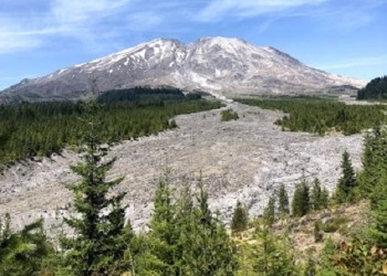
Beginning next to the mudflow that traveled down the Muddy River drainage, the trail climbs steadily through a plantation of young trees before entering groves of giant Douglas fir, silver and noble fir. The trail then emerges on an open ridge top with views east into Ape Canyon and in the distance, Mount Adams. Wildflowers, when in bloom, paint these meadows in vibrant colors. Continuing along the ridge, the trail passes through patches of 1980 standing dead forest before emerging at the top of Ape Canyon, where it terminates at the junction with Loowit Trail #216.
Specific Trail Information
Trail Number
General Information
Ape Canyon Trail #234 is a popular trail for both hikers and mountain bikers. Visitors can expect high mountain bike use on weekends. Please be courteous and share the trail.
Low elevation trails typically melt out by mid-May. High elevation trails typically melt out by mid-July. Snow may persist in spots on north facing slopes. There may be downed trees, washouts, and/or landslides on trails. Carrying mosquito repellent is advisable. Backcountry creeks and streams may dry out so plan ahead in case you need to bring in water. Recreating in burned areas poses greater risks. See safety tips for burned areas. Please assist in reporting wildfires by calling 911 or Columbia Dispatch at (360) 891-5140. Sign up for emergency alerts by county.
$5 per vehicle per day or valid Recreation Pass is required at Ape Canyon Trailhead. See Mount St. Helens Map for fee and payment sites.
No

Address: 42218 N.E. Yale Bridge Rd. Amboy, WA 98601
Phone: (360) 449-7800
Hours: Monday, Wednesday, and Friday, 9am - 4:00pm. (Closed Daily: 12:00 - 1pm). Closed: Tuesday and Thursday (Closed on federal holidays)
Getting There
Trailhead/Starting Points
Directions
From Cougar WA take Lewis River Road east for 2.8 miles. The road then changes to Forest Road 90. Continue on Forest Road 90 to Forest Road 83, approximately 4 miles and turn left. Drive Forest Road 83 for 8.4 miles to the Ape Canyon Trailhead.
Additional Information
Operated By
Forest Service