

Au Sable National Scenic River
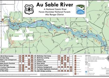
The Au Sable National Scenic River, is a 23-mile portion of the Au Sable River that stretches from Mio to Alcona Pond. President Ronald Reagan signed the law establishing the segment of river as a National Scenic River on October 4, 1984. By receiving this designation, this free-flowing segment from below Mio Pond to the upper end of Alcona Pond received national recognition for its outstanding and remarkable scenic, recreational, biological and historical values and a national commitment to its protection. People have enjoyed the scenic beauty of the Au Sable for hundreds of years.
In pre-European settlement times, Native Americans used the river as a travel route. After European settlement of the area, the Au Sable River was a major throughway for floating white pine to sawmills or waiting barges at ports on Lake Huron. During those years many of the logs and fallen trees that littered the river were carried downstream with the harvested white pine. In recent years efforts have been made to replace logs in the river to help reduce erosion and maintain the world-class trout fishing river as an aquatic habitat.
General Information
County - Oscoda
Open 24 hours a day, 7 days a week unless otherwise posted.
Special Use Permit -
- No special use permit is required for individuals or small groups (74 people or less).
- Permits are required for commercial, event or large groups (75 people or more).
Visit the Passes and Permits section for more information on obtaining a special use permit.
The following rules are available to you on-line or at any office of the Huron-Manistee National Forests. Please take time to read and understand them. General Topic orders apply across the Forests. Applicable Orders -
- Au Sable National Scenic River Corridor; R904-14-18
- Motorized Vehicle Use of Roads, Trails and Off-road Areas; R904-14-02
- Occupancy and Use; R904-14-03
Highlights - Camping is prohibited, except at designated campgrounds or campsites.
Recreation Enhancement Act Fee - Day Use -
- 4001 Bridge Canoe Landing
- Gabions Campground and Day Use Area
- Au Sable Loop Campground and Day Use Area
Camping -
- Gabions Campground
- Au Sable Loop Campground
Canoe Rentals -
- Glennie:
- Alcona Canoe Rental
- Hale:
- Rollways Resort
- Mio:
- Gotts Landing
- Hinchman's Acres Resort
- Oscoda:
- Au Sable River Kayaking Company LLC; B & B LLC (Hunts)
- Oscoda Canoe Rental
Address: 107 McKinley Road Mio, MI 48647
Phone: (989) 826-3252
Hours: Monday to Friday 9:00 a.m. to 4:00 p.m. (Closed on federal holidays)
Getting There
Directions
Location - The scenic portion of the river runs from Mio Dam Pond to Alcona Pond Site. For directions to a particular campground, please visit that campgrounds page.
From Grayling -
Highbanks Overlook
- Travel east on M-72 for 30 miles.
- Turn right and travel south on M-33 for 6 miles.
- Turn left and travel east on County Rd./Curtisville Rd. for 16.5 miles.
- Turn left and travel on Au Sable Rd. for .5 miles.
- Turn left and travel on FR 3993 for .25 miles to parking lot.
Latitude: 44.619185 Longitude: -83.839156
Loud's Rest Stop
- Travel east on M-72 for 30 miles.
- Turn left and travel north on M-72/M-33 for .5 miles.
- Turn right and travel east on McKinley Dr. for 1.5 miles.
- Turn right and travel on FR 4366 into entrance the site and follow the signs.
Latitude: 44.661931 Longitude: -84.1053
Davis Rest Stop
- Travel east on M-72 for 30 miles.
- Turn left and travel north on M-72/M-33 for .5 miles.
- Turn right and travel east on McKinley Dr. for 7.5 miles.
- Turn right and travel south on FR 4371 for .75 miles.
Latitude: 44.651158 Longitude: -83.992207
McKinley Landing
- Travel east on M-72 for 30 miles.
- Turn left and travel north on M-72/M-33 for .5 miles.
- Turn right and travel east on McKinley Dr. for 10 miles.
- Turn right and travel south on Evans Rd. for .5 miles. Cross the river and turn right into the entrance.
Latitude: 44.642129 Longitude: -83.941364
4001 Canoe Landing
- Travel east on M-72 for 30 miles.
- Turn right and go south on M-33 for 6 miles.
- Turn left and go east on County Rd. 604/Curtisville Rd. for 16 miles.
- The entrance is located on the right.
Latitude: 44.651158 Longitude: -83.992207
Parking
All sites except McKinley
Facility and Amenity Information
Restrooms
Restroom information is not currently available for this site.
Water
Potable water is not available at this site.