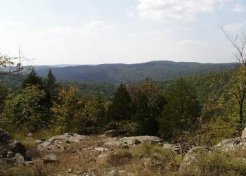
Lindsey Mountain Trailhead
The Bell Mountain Wilderness is a 9,143 acre wilderness is part of the St. Francois Mountains, one of the oldest landforms in North America. The wilderness is named for a family that once lived and farmed along the ridge top that is now known as Bell Mountain. Elevations range from 1,702 feet at Bell Mountain to 970 feet in the Joe's Creek drainage. Local relief is about 600 feet and is characterized by steep felsite and rhyolite outcroppings. Both Bell Mountain and Lindsey Mountain offer outstanding views of the surrounding area. The associated granite glades provide a variety of interesting plant and animal life.
There are approximately 11.9 miles of trails maintained for hikers, including a small segment of the Ozark Trail.
Maps
- Trail System Map (printable)and Trail System Map available on the Avenza app.
- The Wilderness is located on the following quadrangle/topographic maps:
- Johnson Mountain,
- Banner,
- Edgehill and
- Johnson Shut-ins
A map of the Potosi District can be purchased at Mark Twain National Forest offices.
General Information
The Ozark climate is mild enough to make Wilderness visits feasible throughout the year, as long as visitors bring proper gear. When possible, take advantage of this opportunity and plan your 'visit outside the peak spring and fall use seasons.
Private Property – Much of Bell Mountain Wilderness borders private property. Please respect the rights and property of private landowners.
Safety Information
Wilderness has inherent dangers, and is a primitive setting where you meet nature on its own terms.
- Bring a map and compass, and first aid kit.
- During temperate months, be prepared for biting insects, poison ivy and high temperatures.
- Be advised of hunting seasons.
- Avoid using the trail during excessively wet periods.
- Be sure to tell someone your plans,
- don’t hike the wilderness alone and
- carry extra supplies so you are prepared to take care of yourself in case you get lost, injured, or delayed.
- The universal distress signal is three of anything: shots, shouts, smokes, whistles.
- Be prepared to sanitize water for drinking
Camping
Dispersed camping is the term used for free camping anywhere in the National Forest OUTSIDE of a designated campground.
Dispersed camping means there are no toilets, no structures, no trash cans, no treated water, and no fire grates.
There are extra responsibilities required for this type of camp. It's a must to educate yourself before you try it, but we hope the adventure of dispersed camping in the Mark Twain National Forest calls to you!
- Pick a Campsite and follow the Leave No Trace Principles
- Camp 100 feet away from trails and water sources.
- Treat any water found in the area before consuming it.
- Human waste (Feces) must be buried at least 6 inches deep and covered.
- Pack out all of your garbage.
January - December
Wilderness
- Limit your party size to 10 persons;
- no camping within 100 feet of trails, water sources and other camps.
- Terrain is sometimes steep.
- No motorized or mechanized equipment allowed.
- Practice Leave No Trace outdoor ethics;
- Never tie stock directly to trees.
- Commercial use will not be permitted.
- Special uses will not be permitted, except for access to surrounded private property.
- Pack out all of your trash
Trailheads
- No trash containers; please pack out all your trash.
- Dogs on leash
- No fireworks
Trail Use
Dogs are allowed on hiking trails, as long as they are kept on a leash. Unleashed dogs can pose a danger to your pet, the natural resources of the area, and other forest visitors.
- Leashes must be six feet, or shorter, when in developed recreation sites, including trails within the boundaries (36 CFR 261.16(j)) when they are not inside an enclosed vehicle or tent.
- Yield your leashed dog around other hikers and horses.
- Pack out your dogs waste or bury it 100 feet from water and trails.
Camping
- Keep dogs on a six-foot, or shorter, leash when they are not inside a tent.
- Store dog food in bear-resistant containers and feed your pet away from the campsite.
- Pick up and bag your dog’s waste. Place it in a provided trash receptacle or pack it out.
- Do not leave your dog unattended at any time.
- Do not leave your dog in the vehicle on a hot day.
- Keep your dog in your tent or vehicle at night.
- Ensure that there is ample water available for your pet.
Wildlife
- Do not allow them to interact with wildlife

Address: 10019 W. State Hwy. 8 Potosi, MO 63664
Phone: 573-438-5427
Hours: 8:00 am - 4:30 pm, Monday to Friday; District Offices closed 1 - 1:30 for lunch (Closed on federal holidays)
Office Email: sm.fs.marktwainnf@usda.gov
Getting There
Latitude / Longitude
Latitude: 37.628274
Longitude: -90.8311686
Directions
Lindsey Mountain Trail - From St. Louis
- take Hwy. 21 for approximately 90 miles south through Potosi and then Caledonia to Hwy 32
- turn right/west on Highway 32 and travel for about 7 miles to Highway A.
- then travl south about 1.5 miles on Highway A to the trailhead,
- turn left onto Iron County 61 and travel for 1.5 miles and Iron County 61 becomes FR 2228
- Travel 2 miles on FR 2228 and take a right onto FR 2359.
- FR 2359 dead-ends at the trailhead.
Facility and Amenity Information
Accessibility
Restrooms
Restrooms are not available at this site.
Water
Potable water is not available at this site.
Recreation Opportunities
Day Hikes Info
Bell Mountain Trail
When entering the wilderness from the Ottery Creek Trailhead a short, 2 mile trail will take you to an intersection for the Taum Sauk Ozark Trail section and the Bell Mountain trail. If you head south you will be on the Taum Sauk, if you go north on the 1 mile connector trail you will be on the Bell Mountain trail.
The trail can be challenging as it is rugged and rocky, you start at the base of a mountain and work your way up, so there is a lot of climbing.
We recommend you download a digital map or print a map before heading into the wilderness.
If starting from Ottery Creek the trail loop is 12 miles. If you start at the Bell Mountain North Trailhead it's around an 11.7 mile hike.
Lindsey Mountain Trail
This a 2.2 mile out and back trail. The terrain is rocky, and can be difficult and is not marked. This is a primitive and challenging trail.
Backpacking Info
Bell Mountain Trail
When entering the wilderness from the Ottery Creek Trailhead a short, 2 mile trail will take you to an intersection for the Taum Sauk Ozark Trail section and the Bell Mountain trail. If you head south you will be on the Taum Sauk, if you go north on the 1 mile connector trail you will be on the Bell Mountain trail.
The trail can be challenging as it is rugged and rocky, you start at the base of a mountain and work your way up, so there is a lot of climbing.
We recommend you download a digital map or print a map before heading into the wilderness.
If starting from Ottery Creek the trail loop is 12 miles. If you start at the Bell Mountain North Trailhead it's around an 11.7 mile hike.
Lindsey Mountain Trail
This a 2.2 mile out and back trail. The terrain is rocky, and can be difficult and is not marked. This is a primitive and challenging trail.
Horseback Riding Info
Bell Mountain Trail
When entering the wilderness from the Ottery Creek Trailhead a short, 2 mile trail will take you to an intersection for the Taum Sauk Ozark Trail section and the Bell Mountain trail. If you head south you will be on the Taum Sauk, if you go north on the 1 mile connector trail you will be on the Bell Mountain trail.
The trail can be challenging as it is rugged and rocky, you start at the base of a mountain and work your way up, so there is a lot of climbing.
We recommend you download a digital map or print a map before heading into the wilderness.
If starting from Ottery Creek the trail loop is 12 miles. If you start at the Bell Mountain North Trailhead it's around an 11.7 mile hike.
Lindsey Mountain Trail
This a 2.2 mile out and back trail. The terrain is rocky, and can be difficult and is not marked. This is a primitive and challenging trail.
Viewing Scenery Info
The views near the summit of Bell Mountain are some of the best in the Ozarks. From here you can see the rest of the St. Francis mountain range.
Concrete pilings of an old fire tower are right at the top of the summit. The tower is no longer there.
Recreation Groups
This 9,143 acre wilderness is part of the St. Francois Mountains, one of the oldest landforms in North America.