
Stop 8: Big Creek Basin
This is a very small site located on a sharp curve, please be aware of your surroundings and passing traffic if you pull off.
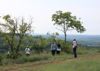
What you see in front of you is oak woodland habitat which surrounds glades and is very important to wildlife and wildflowers that reside in Missouri. Woodlands may have covered a third of Missouri prior to European settlement. Early explorer Henry Rowe Schoolcraft noted the openness of the woods and the abundant grasses and wildflowers growing under the oaks.
While settlement was progressing throughout the state, trees in woodlands were harvested and in some cases woodlands were converted to land more suitable for agricultural purposes. As settlers moved in, many of the natural occurring fires were extinguished, which allowed overstocking of trees in remaining woodlands. Big Creek Basin is an area that the Mark Twain National Forest Ava/Cassville/Willow Springs Ranger District is in the process of restoring to a healthy woodland.
Restoring woodland habitat often begins with thinning the existing woodland canopy and reintroducing prescribed fire to restore the once diverse plant community. Woodlands have evolved with fire and can withstand periodic moderate intensity burns. Tree ring studies have determined that in southwest Missouri fires historically occurred about every three years. Current Forest Service management uses this rotation schedule to emulate historic burn cycles.
Other valuable information used to restore woodlands is government land survey records from the 1830s and 1840s. These are used to generally interpret the composition, dominance, and relative distances between trees as a means of targeting woodland structure.
Dominant woodland trees are oaks, hickories and walnuts. Smaller trees that do well in shade like smoke tree, dogwood, and redbud bring color to the Forest after a long winter. Beautiful wildflowers, grass, and sedges cover the ground and begin to emerge in the spring, blooming through late fall.
Well managed woodlands provide excellent habitat for wildlife. Species commonly associated with woodlands include white-tailed deer, southern flying squirrel, wild turkey, whip-poor-will, scarlet tanager, red-headed woodpecker, Cooper’s hawk, red bat, three-toed box turtle, northern fence lizard, and eastern gray tree frog.
Harder to find critters like eastern collard lizards make their home in glade habitat but woodlands are essential for dispersing individuals to colonialize other glades in close proximity.
Adding an array of color to the forest floor are lowbush blueberry, aromatic sumac, New Jersey tea, grape, and Virginia creeper. Herbaceous plants include little bluestem, big bluestem, wild hyacinth, orange puccoon, butterfly weed, blazing star, milkweed, bristly sunflower, goldenrods, asters, and a variety of sedges.
General Information
Major threats to woodland habitat include non-native invasive plants, feral hogs, and unauthorized off-road vehicle use.
Invasive weeds can outcompete native plant species, which reduces wildlife habitat and diminishes forest health and productivity. Invasive tree species can form dense stands where native trees like oaks and pines can no longer reproduce. Forest Service is actively managing to control invasive weeds such as Sericea lespedeza (Lespedeza cuneata) and Tree of Heaven (Ailanthus altissima) in the Glade Top area.
Feral hogs cause severe damage to the habitat in many ways. They compete for resources with wildlife species. Hogs aggressively consume acorns in the winter months, which are a major food source for white tailed deer and wild turkeys. Hogs are also known predators of ground nests, eating eggs of species such as wild turkey, northern bobwhite quail, and other ground nesting songbirds, which can lead to declining population numbers. Rooting by feral hogs damages soils, causing erosion and pollution of our clear Ozark streams. Disturbed soil from rooting is highly susceptible to non-native plant invasion.
Illegal off-road vehicle use is also a serious threat to woodland habitats. On the Mark Twain National Forest, use of ATV’s, UTV’s, and other off-highway vehicles is restricted to open, numbered forest roads. When motorized vehicles leave these roads they cause damage to the soil, resulting in compaction, rutting, and erosion, and sedimentation in fish habitat. Off-highway vehicles can spread invasive plant seeds, and cause destruction of native vegetation used by wildlife for food and shelter. Off-roading can also destroy archaeological, historical, and natural features, sometimes with irreversible effects.
January - December
Day Use, 6 am to 10pm
When visiting, please remember
- No overnight camping in day use areas at any time of year.
- Dogs must be on a 6 foot leash in the day use area
- No trash containers; please pack out all your trash.
- Fireworks are prohibited.
No fees are required for this site
No fees
When at stops please keep your dog on a 6-foot (or shorter) leash. Don't forget to bring waste bags to clean up after them.
None of the stops have drinking water so make sure to bring enough water (and snacks!) for your furry companion.

Address: 1006 S. Jefferson Ava, MO 65608
Phone: 417-683-4428
Hours: 8:00 am - 4:30 pm, Monday to Friday; District Offices closed 1 - 1:30 for lunch (Closed on federal holidays)
Office Email: sm.fs.marktwainnf@usda.gov
Getting There
Latitude / Longitude
Latitude: 36.675664
Longitude: -92.805222
Directions
From Ava, MO
The byway begins outside of Ava:
- go south on Hwy 5 for three miles to Hwy A
- turn right/west on Hwy A and drive 4 miles to Smallett Junction,
- turn left/south on A409 and Hayden Park
- Drive for 11.8 miles on A409 to the junction of FR147 and A409 and veer right to stay on A409.
- On A409 travel for 2 miles to Big Creek, which is located on the left.
*Note the sign for this site is on a sharp curve.
Parking
1 vehicle
Facility and Amenity Information
Restrooms
Restrooms are not available at this site.
Water
Potable water is not available at this site.
Recreation Opportunities
Scenic Driving Info
Glade Top National Scenic Byway
Glade Top Trail became a National Forest Scenic Byway in 1989.
While much of the Glade Top Trail was significantly improved or constructed outright by the Civilian Conservation Corps (CCC) during the 1930s to the early 1940s, it is probable that a significant proportion of the Trail was used by settlers to access many of the homesteads that existed throughout the region during the late nineteenth and early twentieth centuries. Prior to that time, these same routes of travel were likely used by Native American peoples as they traversed the landscape in pursuit of the area’s natural resources.
Recreation Groups
This 23-mile Scenic Byway is named for the beautiful glades that surround the ridge tops where the Scenic Byway traverses.