
Stop 9: Panorama
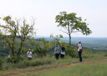
Panorama is a very small pull-off along the Glade Top National Scenic Byway. From here you can see panoramic views of the glades and valley below.
In February 1905, all federal forest administration was consolidated under the Department of Agriculture's Bureau of Forestry. These lands were previously administered by the General Land Office (GLO) and United States Geological Survey (USGS) under the Department of Interior. The Forest Service was established on July 1, 1905, replacing the Bureau of Forestry.
On March 1, 1911, President William Howard Taft signed the Weeks Act. The Weeks Act permitted the federal government to purchase private land in order to protect the headwaters of rivers and watersheds in the eastern United States and called for fire protection efforts through federal, state, and private cooperation. In 1924 Congress passed the Clarke-McNary Act that allowed the United States to purchase lands specifically to further the long-term, sustainable production of timber as well as for the protection of navigation within the watersheds of navigable streams.
In 1929, concerned citizens of Missouri formed the *Missouri National Forest Association to lobby for establishment of National Forests in Missouri so lands could be managed by USFS because of their work in natural resource conservation. In 1933, the Association lobbied the State Legislature to pass the Enabling Act, an act allowing the USFS to purchase lands in Missouri. In 1934, the U.S. Department of Agriculture began purchasing tracts of forested lands in Missouri. The lands were divided into two purchase units, the Clark unit in southeast Missouri headquartered in St. Louis, MO and Gardner unit in southwest Missouri with headquarters located in Springfield, MO. The St. Louis office was relocated to Rolla, Missouri sometime during 1946. Between 1953 and 1973, the location of the headquarters of the National Forests in Missouri changed a few times. In 1973, the Chief of the Forest Service mandated the headquarters be moved to Rolla, MO where the current Mark Twain National Forest Supervisor’s Office remains. In 1976, the Clark and Gardner National Forests became one National Forest named after the most famous Missourian at that time, Mark Twain.
Not all individuals were willing to sell their land to the Forest Service. As a result there is a checkerboard pattern of private and federal lands. You can see private lands from where you are standing with pastures, homes and ponds dotting the landscape.
Fun Fact:
In 1939, President Franklin D. Roosevelt further divided the lands that were known then as the Gardner National Forest into smaller units. The Gardner National Forest was divided into the Pond Fork, Table Rock, and Gardner units of the Gardner National Forest. The land you are currently viewing was part of the Pond Fork unit.
Up until 1986, the Ava/Cassville/Willow Springs Ranger District were managed as three separate units with three District Rangers and offices. In 1986, the Ava and Willow Springs units combined and in 1994, the Cassville unit was added. The Ava/Cassville/Willow Springs Ranger District is managed as one with the main office located in Ava, MO.
General Information
January - December
Day Use, 6 am to 10pm
When visiting, please remember
- No overnight camping in day use areas at any time of year.
- Dogs must be on a 6 foot leash in the day use area
- No trash containers; please pack out all your trash.
- Fireworks are prohibited.
No fees.
When at stops please keep your dog on a 6-foot (or shorter) leash. Don't forget to bring waste bags to clean up after them.
None of the stops have drinking water so make sure to bring enough water (and snacks!) for your furry companion.

Address: 1006 S. Jefferson Ava, MO 65608
Phone: 417-683-4428
Hours: 8:00 am - 4:30 pm, Monday to Friday; District Offices closed 1 - 1:30 for lunch (Closed on federal holidays)
Office Email: sm.fs.marktwainnf@usda.gov
Getting There
Latitude / Longitude
Latitude: 36.664791
Longitude: -92.744599
Directions
From Ava, MO
The byway begins outside of Ava:
- go south on Hwy 5 for three miles to Hwy A
- turn right/west on Hwy A and drive 4 miles to Smallett Junction,
- turn left/south on A409 and Hayden Park
- Drive for 11.8 miles on A409 to the junction of FR147 and A409 and veer left onto FR147
- On FR 147 travel for 3.5 miles to Panorama, which is located on the left.
Parking
2 vehicles
Facility and Amenity Information
Accessibility
Restrooms
Restrooms are not available at this site.
Water
Potable water is not available at this site.
Recreation Opportunities
Scenic Driving Info
Glade Top National Scenic Byway
Glade Top Trail became a National Forest Scenic Byway in 1989.
While much of the Glade Top Trail was significantly improved or constructed outright by the Civilian Conservation Corps (CCC) during the 1930s to the early 1940s, it is probable that a significant proportion of the Trail was used by settlers to access many of the homesteads that existed throughout the region during the late nineteenth and early twentieth centuries. Prior to that time, these same routes of travel were likely used by Native American peoples as they traversed the landscape in pursuit of the area’s natural resources.
Recreation Groups
This 23-mile Scenic Byway is named for the beautiful glades that surround the ridge tops where the Scenic Byway traverses.