
Wolf Junction (GTT Stop 7)
This stop combines Wolf Junction and Willie Lee recreation sites.
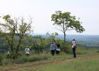
Bateman Trail
From this trailhead you can access the Willie Lee section of the trail. From Willie Lee there is a spur trail that goes up the hill and into the woods and connects through the trees to Bateman Trail System. You’ll have a drop of almost 400 feet between the trailhead and the creek.
- Rating: Moderate
- Length: 16 miles
- Best Seasons: Fall, winter, and spring
- Surface Type: Unsurfaced, native material
- Average Trail Grade: 12 - 20%, moderately steep to steep and challenging for some hikers.
Glade Top National Scenic Byway - Stop #6
History of the Willie Lee Homestead and Wolf Junction
The 1930s plat book shows J.W. Findley as the owner of the land now known as Wolf Junction. Other individuals owned the land before Mr. Findley, but he left a lasting impression that is part of Ozarks history. Mr. Findley was a noted author, local historian, and was known as the “walking preacher of the Ozarks”. In his retirement, J.W. Findley wrote 8 books, each relating to the Missouri Ozarks. He was 92 years old when he died in 1990 while living in Ava, MO. You can tell by the following quote that J.W. Findley was fond of the Ozarks:
“And when Indian Summer comes and God hangs a shimmering curtain of blue purple over these Ozark Hills, and the trees put on their robes of scarlet and gold, just take a drive over the Glade Top (Skyline) drive and you’ll say you’ve seen a little bit of “Ozark Glory,” too. God must have loved our hills a lot, or He wouldn’t have made so many of them.” (Ozark Glory, 1985 J.W. Findley)
The White River Historical Society located in Forysyth, MO was very helpful in gathering information for this stop. If you would like to learn more about Taney County history, visit their website.
Transfer to USDA Forest Service
Willie and Ollin Lee purchased the land from J.W. Findley and the Rialto Land and Mining Company and sold the property to the Forest Service in 1970 under authority of the Weeks Act, which permitted the federal government to purchase private land to protect the headwaters of rivers and watersheds in the eastern United States. The Weeks Act also called for fire protection efforts through federal, state, and private cooperation.
In 1999, the Forest Service acquired lands from Calvin Bateman. The Bateman property is situated west and north of the Willie Lee Homestead. In 2007, the Forest Service designated a non-motorized trail system in the area that is known as the Bateman trail system.
Rangeland
You may have noticed cattle guards while driving the Glade Top Trail. When the Mark Twain National Forest was established, Missouri was open range for livestock. Unmanaged grazing allowed domestic livestock including cattle, goats, and sheep to compete with wildlife for forage and mast. Unmanaged grazing also interfered with tree growth, depleted rich grass and forb ground cover and caused soil instability.
In 1965, the Mark Twain National Forest was closed to open range grazing under federal regulations. Grazing was still allowed, but under a managed system. Today, the Forest has grazing allotments under a permit system. The Bateman area is one of several grazing allotments on the District that is active.
Fun Fact: Local residents refer to the section of road from Wolf Junction to Highway 125 as the “6 mile stretch”.
Fun Fact: From records at the White River Historical Society, the original owner of the J.W. Findley tract of land known as Wolf Junction was George W. Lee in 1910.
General Information
Camping
Dispersed camping is allowed at Willie Lee, please note there are no fire rings or tables available.
Partners
The Forest Service worked with local equestrian groups to designate the trails. The following are the local group’s websites.
January - December
Day Use Hours:
- 6:00 AM to 10:00 PM
When visiting, please remember
- No overnight camping at Wolf Junction
- Dogs must be on a 6 foot leash in the day use area
- No trash containers; please pack out all your trash.
- Fireworks are prohibited.
No fees are required for this site
Trail Use
Dogs are allowed on hiking trails. Please leash your dog, unleashed dogs can pose a danger to your pet, the natural resources of the area, and other forest visitors.
- Leashes must be six feet, or shorter, when in developed recreation sites, including trails within the boundaries (36 CFR 261.16(j)) when they are not inside an enclosed vehicle or tent.
- Yield your leashed dog around other hikers and horses.
- Pack out your dogs waste or bury it 100 feet from water and trails.
Camping
- Keep dogs on a six-foot, or shorter, leash when they are not inside a tent.
- Store dog food in bear-resistant containers and feed your pet away from the campsite.
- Pick up and bag your dog’s waste. Place it in a provided trash receptacle or pack it out.
- Do not leave your dog unattended at any time.
- Do not leave your dog in the vehicle on a hot day.
- Keep your dog in your tent or vehicle at night.
- Ensure that there is ample water available for your pet.
Wildlife
- Do not allow them to interact with wildlife

Address: 1006 S. Jefferson Ava, MO 65608
Phone: 417-683-4428
Hours: 8:00 am - 4:30 pm, Monday to Friday; District Offices closed 1 - 1:30 for lunch (Closed on federal holidays)
Office Email: sm.fs.marktwainnf@usda.gov
Getting There
Latitude / Longitude
Latitude: 36.696389
Longitude: -92.78376
Directions
From Ava, MO
The byway begins outside of Ava:
- go south on Hwy 5 for three miles to Hwy A
- turn right/west on Hwy A and drive 4 miles to Smallett Junction,
- turn left/south on A409 and Hayden Park
- Drive for 11 miles on A409 to get to Willie Lee
- Drive another 1/8 mile on A409 from Willie Lee to Wolf Junction.
Parking
- Willie Lee: 12 vehicles with trailers
- Wolf Junction: 2 vehicles
Facility and Amenity Information
Restrooms
Restrooms are available at this site.
Water
Potable water is not available at this site.
No stops along the byway have potable water
Picnic Tables
Picnic tables are available at this site.
Willie Lee, Wolf Junction
Horse/Pack Animal Information
Horse/Pack animals are allowed at this site.
Nearby Trails
Recreation Opportunities
Horseback Riding Info
Willie Lee serves as a designated trailhead for the Bateman Trail. From Willie Lee there is a spur trail that goes up the hill and into the woods and connects through the trees to Bateman Trail System.
Bateman Trail: 16-miles
The Bateman Trail, a non-motorized trail system, consists of approximately 16 miles of trail. This hiking and equestrian trail, leads you through limestone glades that can be seen throughout the trail system. Landscapes vary from gently rolling hills to moderately steep terrain with rock outcrops and tall grass prairies. Natural water for horses along the trail is very limited and may be seasonal.
Picnicking - Single Info
Both Willie Lee and Wolf Junction are small pull-offs along Glade Top National Scenic Byway where you can stop and have a picnic lunch.
Wolf Junction is the site of an old homestead, you may still see the remains of the foundation, while Willie Lee has the remains of an old cellar in the area.
No. of Sites
- Willie Lee - 1 table
- Wolf Junction - 1 table
OHV Road Riding Info
Many visitors use Willie Lee as a location for loading/unloading their ATVs/OHVs for riding along the byway.
Glade Top National Scenic Byway
Glade Top Trail became a National Forest Scenic Byway in 1989.
While much of the Glade Top Trail was significantly improved or constructed outright by the Civilian Conservation Corps (CCC) during the 1930s to the early 1940s, it is probable that a significant proportion of the Trail was used by settlers to access many of the homesteads that existed throughout the region during the late nineteenth and early twentieth centuries. Prior to that time, these same routes of travel were likely used by Native American peoples as they traversed the landscape in pursuit of the area’s natural resources.
Driving Routes Info
Glade Top National Scenic Byway
Glade Top Trail became a National Forest Scenic Byway in 1989.
While much of the Glade Top Trail was significantly improved or constructed outright by the Civilian Conservation Corps (CCC) during the 1930s to the early 1940s, it is probable that a significant proportion of the Trail was used by settlers to access many of the homesteads that existed throughout the region during the late nineteenth and early twentieth centuries. Prior to that time, these same routes of travel were likely used by Native American peoples as they traversed the landscape in pursuit of the area’s natural resources.
Recreation Groups
This 23-mile Scenic Byway is named for the beautiful glades that surround the ridge tops where the Scenic Byway traverses.