
Highland Scenic Highway
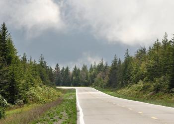
The Highland Scenic Highway is a designated National Scenic Byway that extends 43 miles from Richwood to US Route 219, north of Marlinton. Four scenic overlooks provide a comfortable rest stop, with panoramic views of the surrounding mountains and valleys. The Highway traverses the mountainous terrain of the Allegheny Highlands and Plateau, and rises from 2,325 feet near Richwood to more than 4,500 feet.
The Highway is a paved two-lane road, designated as State Routes 39 and 150. Route 150 is a 23-mile Parkway section that is not maintained in the winter. Winter travel on the road may be treacherous, the road is often impassible during winter storms. Travel is highly discouraged on Route 150 between November and April. Toilets at overlooks are closed in winter.


General Information
Closed when snow covered.
Additional Resources
- Speed limits are 55 mph for the State Route 39/55 section and 45 mph for the Parkway section.
- Commercial truck traffic is not allowed on the Parkway.

Address: 932 Northfork Cherry Road Richwood, WV 26261
Phone: (304) 846-2695
Hours: Monday through Friday 8 am to 4:30 pm Eastern time, unless otherwise posted. (Closed on federal holidays)
Getting There
Directions
Traveling south to north, follow State Route 150 from the Cranberry Mountain Nature Center twenty-two miles to US Route 219. The scenic overlooks are named Williams River, Big Spruce, Little Laurel, and Red Lick. The sites are dispersed along the route.
Facility and Amenity Information
Restrooms
Restrooms are not available at this site.
Water
Potable water is not available at this site.
Recreation Opportunities
Picnicking - Single Info
Each scenic overlook has a paved parking area, restrooms, and a picnic shelter with table.
Backpacking Info
For those looking for a backpacking experience, there are a variety of camping opportunities. Some popular areas include Cranberry and Tea Creek area. Minimum impact methods are encouraged, including pack-it-in/pack-it-out trash policy. Visitors are asked to camp away from trails and streams.
Day Hikes Info
Trailheads are located near each Overlook.
Scenic Driving Info
Four Scenic overlooks located on the Parkway portion of the Highway provide spectacular views of the Allegheny Highlands. On a clear day, each scenic overlook provides a splendid view of the surrounding Allegheny Mountains. Spring blossoms, summer greenery, and fall colors are special attractions along the Highland Scenic Highway.
Interpretive Areas/Exhibits Info
Several educational signs and interpretive trails are located along the Highland Scenic Highway (HSH). There are four scenic overlooks on the HSH, each with a unique viewshed into the surrounding valleys and a sign describing the area.
At Big Spruce Overlook, there is an accessible boardwalk describing the logging and fire history of the Black Mountain area. Black Mountain is the highest point on the highway at 4,550’.
The Honeycomb Rocks interpretive trail provides an accessible route through unusual geologic formations.
Across from the Little Laurel Overlook, signs guide visitors through the Tea Creek Meadow Interpretive Trail while describing the different ecosystems found there.
Snowmobiling Info
Snowmobiling is available on the Parkway Section of the Highland Scenic Highway. Note: The Highland Scenic Highway is not maintained in the winter months.
XC Skiing/Snowshoeing Info
Recreation areas with activity XC Skiing/Snowshoeing:
Cross country skiing and snowshoeing is available on the Highland Scenic Highway. Near the intersection of the Highland Scenic Highway and US 219, there is a small trail system with a centrally located warming hut.