

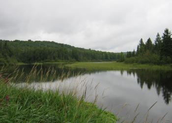
Brule Lake
Brule Lake located on the Michigan and Wisconsin border provides excellent fishing with a good variety. This has two boat ramps, one on the north end and one on the south end of the lake. Also located next to Brule Lake is Stateline Picnic Area and Stateline/Treaty Tree Hiking Trail.

General Information
January - December

Address: E23979 US 2 East Watersmeet, MI 49969
Phone: 906-358-4551
Hours: Monday - Friday, 8:00 a.m. - 4:00 p.m. (CT) (Closed on federal holidays)
Getting There
Latitude / Longitude
Latitude: 46.0435201
Longitude: -88.85050253
Directions
To get to Brule Lake from Iron River, Mi., take US 2 west, turn south on M 73, go approximately 3/4 mile, turn right (west) on Lake Ottawa Road, go approximately 7.5 miles, turn left on West Brule Road. Travel another 2 miles and the boat ramp will be on your left. From Watersmeet, Mi., take US 2 east 28 miles, turn south on M 73, go approximately 3/4 mile, turn right (west) on Lake Ottawa Road, go approximately 7.5 miles, turn left on West Brule Road. Travel another 2 miles and the boat ramp will be on your left.
Closest Town: Iron River, Michigan
Facility and Amenity Information
Water
Potable water is not available at this site.
Other Amenities
- Parking
- Toilets
- Boat ramp
Recreation Opportunities
Fishing - Lake & Pond Info
Brule Lake located on the Michigan and Wisconsin border provides excellent fishing with a good variety. This has two boat ramps, one on the north end and one on the south end of the lake.
- Fishing Mode: Bank or boat
- Fish Species: Northern Pike, Walleye, Bass, Musky, and Panfish
- Fishing Platform: No
- Water Temperature: Cold/Warm
- Fishing Method: Varies
- Water/Flow Level: Depth is 20 feet
- Best Season: July
- Difficulty Level: Easy to Intermediate
Day Hikes Info
The Stateline/Treaty Tree Trail is a Stateline – Mile Post Zero National Recreation Trail is 4/10 of a mile trail that takes you through hardwood forest that takes you to historic destinations on the Brule River. The trail is easy, with relatively flat surfaces on a dirt trail.
- Best Season: May-October
- Difficulty Level: Easy to Intermediate
Picnicking - Single Info
Stateline Picnic Area is located next to the boat ramp to Brule Lake. This picnic area is not maintained and has limited amenities available. However, this is a very quiet and scenic area for your enjoyment.
Best Season: June-August