

Recreation
The Cherokee National Forest is divided into 15 different Recreation Regions. Each one offers a variety of nature-based recreation opportunities and settings to enjoy. You can use the drop-down menus labeled Recreation Regions or Opportunities to find places to visit or things to do. Both menus will take you to helpful information for planning your trip!

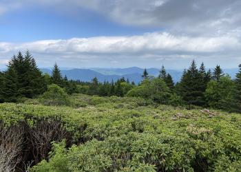
Most of the region is remote backcountry, including Bald Mountain Ridge Scenic Area and Sampson Mountain Wilderness. Roads are limited, but…

This Region is known for solitude and backcountry adventure, with Big Frog Wilderness being a destination for backpacking, day-hiking and hunting.

This region provides opportunities for solitude and backcountry experiences. You will find ample opportunities for fishing, horseback riding,…

Heritage and culture experiences are the primary emphasis in this area. It is home to the nationally recognized Millennium Trail, The Unicoi…
This area’s wooded mountainsides and creek gorges are linked by an extensive road and trail system. Activities include fishing, hiking, horseback…
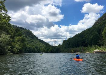
Forested hillsides and pastoral river bottoms complement the beauty of Hiwassee River Gorge. Fishing, rafting, canoeing and hiking are popular…
Holston Mountain provides a scenic backdrop for South Holston Lake and is a venue for boating, water skiing, swimming, fishing and horseback riding.A…

Rugged mountain solitude can be experienced throughout this area. Long distance backpacking, trout fishing and the shortest tunnel in the world are…

World class whitewater, mountain biking trail systems, environmental education programs, highly developed camping, and scenic byways are a few…
Favorite activities in this remote area include whitewater rafting, hiking and camping.Located between the French Broad and Pigeon Rivers, this area…
This region's steep rugged mountainsides, high-elevation balds and hollows are richly diverse, home to unique and rare plants and animals.Look for…

Starr Mountain is a popular Region of the national forest for horse riding & camping with nearly 20 miles of trails and a number of roads available…
This area provides outstanding opportunities for fishing, camping, hiking, and scenic driving. It is also home to the popular Indian Boundary…

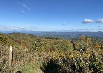
Backcountry trails, scenic driving and the Nolichucky River provide opportunities for outdoor adventure. High elevation balds along the Unaka…
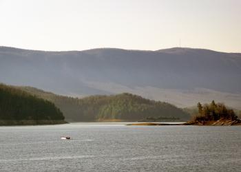
Water recreation is abundant in this area, featuring Watauga Lake; the Doe, Elk and Watauga rivers; several streams and seven waterfalls.Highly…
Recreation
Allen Branch Pond
Try your luck at fishing for bass, bluegill and catfish from the shoreline or one of the fishing piers on this 2.5 acre pond.Enjoy a walk around the accessible quarter-mile…
Apalachia Powerhouse Launch
Site Open
This is a popular launch ramp for the Hiwassee River Gorge.
Appalachian National Scenic Trail
Stretching over 14 states and crossing more than 60 federal, state, and local parks and forests, more than 150 miles of The Appalachian National Scenic Trail traverse the Cherokee National Forest…
Baby Falls Day Use Site
Site Open
The Baby Falls Day Use Site, offers picnicking and water play nearby the popular Bald River Falls.
Backbone Falls Hike
A short loop hike following a developed trail with rock steps and walkways that provides multiple viewpoints of the 45-foot Backbone Falls.
Backbone Rock Recreation Area
Site Open
Backbone Rock Recreation Area is located along Beaverdam Creek in northern Johnson County. Backbone Rock gets its name from a spur ridge on Holston Mountain that abruptly ends at a bend in Beaverdam…
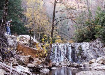
Bald River Falls
The 90 foot high Bald River Falls is recognized as one of the most spectacular waterfalls in the region. It is easily accessed from Tellico River Road (NFRS 210), and provides outstanding…
Bald River Gorge Day Hike
Trail #88, Bald River is approximately 5.6-miles one way. It generally follows Bald River through the gorge from a parking area at Bald River Falls located on Forest Road 210 (Tellico River Road)…
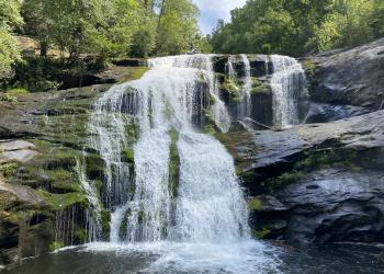
Benton Falls Hike
Site Open
The Benton Falls Trail is an easy 1.5 mile (each way) hike to the 65 foot high waterfall.
Benton Mackaye Trail in Tennessee
The Benton MacKaye Trail, named after the Massachusetts forester and regional planner who originally envisioned the continuous trail along the crest of the Appalachian Mountain chain (A.K.A. The…