Recreation


Boundary Waters Canoe Area Campsite

Discover an Area by Activity

Select an activity to find an area to visit.

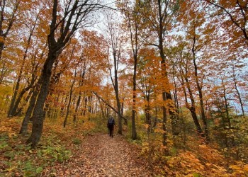
Explore the Superior National Forest

2,000 miles of trails designed for hiking, hunting, riding and more. The Forest offers an expansive variety of ways to get outside and enjoy the outdoors. It’s All Yours!

  • Camp on one of the many developed "fee", or backcountry campsites, most of which are on a body of water.
  • Boat, fish, swim or picnic at one of lake accesses, fishing piers, swimming beaches, or picnic areas.
  • Drive on one of three national scenic byways.
  • Explore the Boundary Waters Canoe Area Wilderness, with over 800,000 acres it is the largest designated wilderness in the eastern.
  • Hiking

    Woman hiking in the woods

    Grab your boots, water bottle, a snack, and maybe the bug repellent. There are over 400 miles of hiking trail in the Superior National Forest

  • Wilderness

    Boundary Waters Canoe Area Wilderness sunset

    Explore the Boundary Waters Canoe Area Wilderness.

  • Canoeing

    Woman canoeing in Boundary Waters Canoe Area Wilderness

    Travel and explore miles of waterways.

Plan Your Trip

Find a mapFind a passFind an officeKnow Before You Go

Recreation Map

Map showing recreational areas. Map Information

Recreation Conditions Report

Area Name Status Area Conditions
Birch Lake Campground & Backcountry Sites Open Open Open with full amenities
Boundary Waters Canoe Area Wilderness Open Open
Cadotte Lake Campground Open Open Open with full amenities
Crescent Lake Campground & Backcountry Sites Open Open Open with full amenities
Devil Track Lake Campground Open Open
Divide Lake Campground & Backcountry Sites Open Open
East Bearskin Lake Campground Open Open
Echo Lake Campground & Backcountry Sites Open Open Open with full amenities
Fall Lake Campground Open Open Open with full amenities
Fenske Lake Campground Open Open Open with full amenities
Flour Lake Campground Open Open
Iron Lake Campground Open Open
Kimball Lake Campground Open Open Open with full amenities
Lake Jeanette Campground & Backcountry Sites Open Open Open with full amenities
Little Isabella River Campground Open Open Fee required. Campground open
McDougal Lake Campground Open Open Open except sites 17 & 19. Hiking trail is still closed.
McDougal Lake Trail Closed Closed Closed for site rehabilitation after the 2021 Greenwood Fire. McDougal Campground will open to the public on May 11, 2023, except for campsites 17 and 19. The hiking trail is still closed.
Ninemile Lake Campground Open Open Open with full amenities
Pfeiffer Lake Campground & Backcountry Sites Open Open Open with full amenities
Sawbill Lake Campground Open Open Open with full amenities
South Kawishiwi River Campground Open Open Open with full amenities
Sturgeon River Trail None None In June of 2018, a regularly scheduled bridge inspection was conducted on the Sturgeon River Trail bridges, and one was found to be unsafe for continued use and beyond reasonable repair. The Forest Service has officially removed the bridge. As a result, the portion of the Sturgeon River Trail system located between Forest Road 279 and Junction 4 will be closed indefinitely. See a map of the closure.
In the winter, visit www.skinnyski.com for current ski trail conditions. 
Temperance River Campground Open Open Open with full amenities
Trail's End Campground Open Open Open with full amenities. All sites open except for sites 29 - 33.
Two Island Lake Campground Open Open Open with full amenities
Whiteface Reservoir Campground Open Open Open with full amenities

Spotlights

Boundary Waters Canoe Area Wilderness

BWCAW

Established in 1964 as Federally Designated Wilderness (pdf), the Boundary Waters Canoe Area Wilderness is over one million acres of rugged and remote boreal forest in the northern third of the Superior National Forest in northeastern Minnesota.

The BWCAW extends nearly 150 miles along the International Boundary, adjacent to Canada’s Quetico and La Verendrye Provincial Parks, is bordered on the west by Voyageurs National Park, and by Grand Portage National Monument to the east. The BWCAW contains over 1,200 miles of canoe routes, 12 hiking trails and over 2,000 designated campsites. The BWCAW is composed of lakes, islands, rocky outcrops and forest.

The BWCAW is the only large temperate lake-land wilderness in the National Wilderness Preservation System and is renowned for its water-based recreational opportunities. The sculpting of the landscape by powerful glaciers over an immense period of time has left behind a variety of landforms and rocks as well as thousands of lakes and streams, interspersed with islands. This network of connecting waterbodies provides unique opportunities for long distance travel by watercraft—a rare experience within the continental United States.

Prepare for your Wilderness Trip

Successful trips don't just happen. Plan ahead for the BWCAW! Visitors can find solitude, adventure, risk, and excitement but the trip planning begins months before entering the Wilderness.

The BWCA Wilderness is one of the most visited wilderness areas in the country. High visitation translates to the potential for impacts to natural resources. We need your help treading lightly on the Wilderness; to keep it full of solitude and pristine for future visitors like you.

Prior to reserving your permit, please review the following to ensure a wilderness trip is right for you:

Be aware tht wilderness has inherent dangers, and is a primitive setting where you meet nature on its own terms. Trails are not well marked, if they are marked at all. If you are a newcomer to camping, or even an experienced backpacker, but not canoe camper, consider camping outside of the BWCAW on one of the 254 backcountry sites on the Forest, or one of our free rustic campgrounds.  There you can experience many of the same things as you do in the Wilderness, but without the need for permits and with easier access to emergency services.

More About Boundary Waters Canoe Area Wilderness