Explore the Forest!
The South Warner Wilderness of the Modoc National Forest is located in the southeast section of the Warner Mountain Ranger District and is 18 miles long by 8 miles wide.
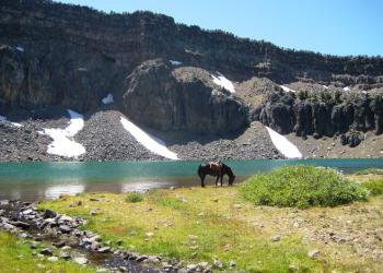
The South Warner Wilderness covers over 70,000 acres of rugged peaks and valleys, perfect for exploration. Designated as a Primitive Area in 1931 and recognized as a wilderness by Congress in 1964, it was expanded in 1984 by the California Wilderness Act. Situated in eastern Modoc County at the southern end of the Warner Mountains, the wilderness ranges from 5,800 feet at Clear Lake to 9,892 feet at Eagle Peak. Notable peaks include Warren Peak at 9,710 feet and Eagle Peak, the highest in the area. The dramatic cliffs behind Patterson Lake on Warren Peak highlight the stunning geography of this wilderness.
The wilderness features trailheads, campgrounds, corrals, and staging areas for equestrians, along with excellent facilities for hikers and backpackers. With over 80 miles of trails, hikers and equestrians can create various routes and loops. No wilderness permits are required, but please sign in at the trailhead. The sign-in sheets help track wilderness visitation and are not used to monitor overdue individuals. A search and rescue will only be initiated if you are reported missing, so inform someone of your travel plans and expected return time. If someone is overdue, report it to the Modoc Sheriff's Office at 530-233-4416. Provide the starting and ending trailheads, a description of your vehicle (license plate number, make, color, and year), and the names of everyone in your party. Ensure this information is left with a responsible person at home.
A short hike into the South Warner Wilderness leads to the overlook for Mill Creek Falls, which flows year-round but is especially impressive in spring when the snow melts.
The trailhead is at the end of the only paved road to the wilderness boundary, about a 45-minute drive from Alturas via Likely and Jess Valley. The Mill Creek Falls Campground offers parking for day hikers and backpackers, along with reasonably priced campsites. The falls overlook is a quarter-mile uphill from the campground. To reach Clear Lake, backtrack a few hundred feet to the south fork of the trail.
The best time to photograph the falls is late morning to just after noon when the sun is overhead and casts fewer shadows.
The Medicine Lake Highlands span over 200 square miles and are one of North America's unique geological regions, featuring the Glass Mountain Obsidian Flow. These highlands were formed by the Medicine Lake volcano around 500,000 years ago. Between 180,000 and 100,000 years ago, the central part of the volcano collapsed, creating a caldera that is 7.5 miles long and 4.3 miles wide. Lava then emerged through the fractures, leading to the formation of rim volcanoes that expelled lava onto the caldera floor. Visitors can explore several rim volcanoes, including Mount Hoffman, Medicine Mountain, Badger Peak, Grouse Hill, Red Shale Butte, Glass Mountain, and Lyons Peak.
The Medicine Lake Highlands features moderately sloping to steep mountains, with vegetation such as sugar pine, red and white fir, and lodgepole pine at higher elevations. Snow usually closes the area from mid-November to mid-June, accumulating an average of 10 feet and limiting access to over-the-snow vehicles and cross-country skiers.
The Doorknob Snowmobile Park, located south of Lava Beds National Monument, offers a paved parking lot, warming hut, and restrooms. Groomed trails connect to Medicine Lake and three neighboring Snow Parks, totaling over 200 miles.
Covering more than 200 square miles, the Highlands is known for unique geological features, including the Glass Mountain Obsidian Flow. Medicine Lake, situated in a volcanic caldera, has no known outlets yet remains clear and clean.
Obsidian and pumice are prevalent here, with evidence of thousands of years of Native American use. Collecting obsidian in this area is illegal; however, permits for collection are available at locations in the Modoc National Forest.
Notably, NASA astronauts trained in the pumice fields for moon landings in the 1960s. Pumice is also used for building materials and creating the "stone-washed" look in denim.
Restrooms are available at the Medicine Lake Day Use Area and Campgrounds.
The Devil’s Garden is an expansive prehistoric lava flow, with areas of sparse vegetation, rough broken lava rock, juniper trees, and sagebrush flats in a semi-arid region covering about a half-million acres.