
2020 Winter Flood Damage and Repair
Background/Overview
On Feb. 6, 2020, the Pomeroy and Walla Walla Ranger Districts of the Umatilla National Forest experienced substantial road and trail damage from region-wide flooding across northeast Oregon and southeast Washington. Flood damage is significant and the forest has implemented long-term temporary closures along the Umatilla River, South Fork Walla Walla River and Tucannon River until critical repairs can be completed. Ground access is restricted to affected areas due to the many miles of damaged county roads. The Umatilla National Forest conducted an aerial reconnaissance flight on Monday, Feb. 10, 2020, to get a preliminary assessment of flood damage. Forest staff are currently working on options to secure funding and resources to conduct repairs. Until those repairs can be completed, damaged areas are closed for public safety.
2020 Flood Effected Watersheds Map
View photos of the damage on our 2020 Umatilla National Forest flooding album.
Current Conditions/Repair Status
Last Updated: May 1, 2020
- Flood repair activities are ongoing, and anticipated to increase, as the Umatilla National Forest received approval for Emergency Relief for Federally-Owned Roads (ERFO) funds through the Federal Highway Administration.
- These funds will be used to complete repairs in the Tucannon, Umatilla, and South Fork Walla Walla River watersheds.
- Staff will begin completing site-specific damage survey reports to identify specific repair needs and cost estimates.
- The Forest anticipates work will begin this summer and likely will be ongoing over the next couple of years.
Apr. 3, 2020
- The Forest is working closely with Federal Highways and district personnel will help in the short-term to collect field information that will better inform future decisions and cost estimates to continue work into the future.
- Forest Service Staff are completing more comprehensive assessments of on-the-damage in the Tucannon watershed and developing repair plans for work this spring.
- At this time, all flood-damage closures remain in place.
Mar. 18, 2020
- Forest staff have submitted a request for Emergency Relief for Federally-Owned Roads (ERFO) funds through the Federal Highway Administration to complete repairs in each of these watersheds.
- The Forest will prioritize and complete temporary repair work to gain access to certain parts of the forest as weather and funding permits.
Feb. 14, 2020
- The Forest is working on several tasks to respond to the flooding impacts, with public safety being the primary objective.
- Follow-up aerial reconnaissance flights and on-ground assessments will be necessary to identify extent of damages to Forest infrastructure.
- The Forest is coordinating closely with the Oregon State Fire Marshall’s office, the Confederated Tribes of the Umatilla Indian Reservation and local county commissioners. The Forest will seek shared stewardship opportunities with the states and counties to support joint efforts for repair work.
- Forest engineering staff are coordinating with the Pacific Northwest Regional Office to submit for Emergency Relief for Federally-Owned (ERFO) roads through the Federal Highway Administration.
- Employees will place barricades on the ground to prevent access into closure areas. Closure orders are in effect.
- The Forest has established a Flood Assessment and Repair Team to identify damage and develop a repair plan. Walla Walla District Fire Management Officer Mike Moore is leading this team.
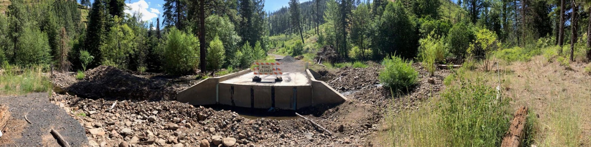
TUCANNON RIVER
Last updated: June 2, 2021
- Some minor repair work was completed this spring on FSRs 47, 4620, 4712 and 4713. This summer FSR 4712 will receive more intensive repairs.
- Additional information will be posted when repair work begins.
Oct. 23, 2020
- Forest officials on the Pomeroy Ranger District will reopen motorized access on Forest Service Roads (FSR) 47, 4712 and a portion of FSR 4713 on Saturday, Oct. 24.
- Work has been ongoing this year to repair the Little Tucannon bridge, FSR 47, 4620, 4712, and 4713. Culvert replacement work on FSR 4713 is ongoing south of the Panjab Campground. The public will not be able to drive to Panjab or Meadowcreek trailhead until contractors finish final repair activities next week. Ladybug and Panjab campgrounds are open.
Oct. 2, 2020
- Contractors will begin additional repair work on the Tucannon River Road (Forest Service Road 47) next week. The repair work will be ongoing for two to three weeks with the objective of reopening motorized access on Forest Service Roads (FSR) 47, 4712 and 4713 upon completion.
- Work is anticipated to begin as early as Oct. 5 and will include repairs on the Little Tucannon bridge to create a fish bypass and remove debris from under the bridge deck, followed by additional repair work on FSR 47 to improve the road surface and remove extensive rockslides.
- The contractors will also work on FSR 4713 between Panjab Campground and Panjab Trailhead to allow vehicle traffic in this area.
- While work is ongoing Forest Service Road (FSR) 47 will stay closed to motorized access at the Little Tucannon bridge. FSR 4712 and FSR 4713 will also remain closed.
Sept. 25, 2020
- While the area closure associated with the Rattlesnake Fire has been lifted the road closures remain in place. These closures include a portion of Forest Service Road (FSR) 47 from the bridge to the intersection with FSR 4712 and FSR 4713, which also both remain closed.
- The roads within this area are closed while ongoing repair work is completed to fix washouts, debris slides, hazard trees, and other damage.
July 24, 2020
- The Umatilla National Forest is re-opening additional public access into the Tucannon River watershed after completing hazard tree removal, as well as identifying and signing designated parking areas. Effective Friday, July 24, the Umatilla National Forest will move the closure gate on the Tucannon River Road (Forest Service Road 47) from the Tucannon Campground to the Little Tucannon bridge.
- Additionally, the Forest has re-opened Patrick Grade (Forest Service Road 4620) from the Forest boundary to the Little Tucannon bridge.
- The remainder of Forest Service Road (FSR) 47 will stay closed to motorized access due to flood damage, hazard trees, and ongoing repair work.
- The Forest is authorizing non-motorized access beyond the bridge, including hiking, horseback riding, or bicycling.
- In addition, the following roads and trails remain closed along the Tucannon River: Motorized access on portions or all of Forest Service Roads 4712, 4620 and 4713, as well as the Meadow Creek Trail #3123, Panjab Trail #3127 and Rattlesnake Trail #3129.
- Access to Camp Wooten and some other state campgrounds is also restricted.
June 23, 2020
- To allow additional public access, the Umatilla National Forest is adjusting the closure gate today on the Tucannon River Road (Forest Service Road 47) from the Tucannon Fish Hatchery to the Tucannon Campground. The new closure boundary will be located just past the campground.
- The Tucannon Campground will also reopen today for overnight camping.
- The remainder of Forest Service Road (FSR) 47 will stay closed due to flood damage, hazard trees, and ongoing repair work. In addition, the following roads and trails remain closed along the Tucannon River.
- Portions or all of Forest Service Roads 4712, 4620 and 4713 are closed, as well as the Meadow Creek Trail #3123, Panjab Trail #3127 and Rattlesnake Trail #3129. Access to Camp Wooten and some other state campgrounds are also restricted.
May 1, 2020
- Forest Service staff also discovered more debris slides on FSR 47 between Cow Camp bridge and Panjab bridge. In partnership with Garfield County, engineers inspected all bridges and identified minor repair needs.
- The public is reminded that several roads and trails are closed in areas with the most significant flood damage. Detailed closure maps and updates on flood repair activities are available on the Forest website and at any Forest office. Closure signs will also be posted on the ground.
- The Tucannon River Road (Forest Service Road 47) on the Pomeroy Ranger District will reopen on May 5 up to the Tucannon Fish Hatchery. The remainder of Forest Service Road (FSR) 47 will stay closed due to flood damage and ongoing repair work. Re-opening this section of FSR 47 will allow the public access to the state campgrounds and ponds along this road.
- The following roads and trails are closed along the Tucannon River: Portions or all of Forest Service Roads 47, 4712, 4620 and 4713 are closed, as well as the Meadow Creek Trail #3123, Panjab Trail #3127 and Rattlesnake Trail #3129. Access to Camp Wooten and some other state campgrounds are also restricted.
Apr. 3, 2020
- Contractors have completed the first phase of planned repair work on Forest Service Road (FSR) 47, which included removing debris slides up to the Little Tucannon Bridge, temporary repair of damaged pavement, and restoring water drainage features by cleaning and or replacing damaged culverts.
- In partnership with Garfield County, a bridge engineer inspected the Little Tucannon Bridge and found no structural damage to the bridge. The high flood event washed away a large amount of material at the approach of the Little Tucannon bridge and that material still needs to be replaced.
- Forest Service staff discovered more debris slides on FSR 47 between Cow Camp bridge and Panjab bridge. Engineers inspected these bridges and determined that both bridges are structurally sound, however the Cow Camp bridge needs minor repairs around the base of the wing walls where rip-rap was moved during the flood.
Mar. 25, 2020
- In partnership with the Washington Department of Fish and Wildlife, the Umatilla National Forest has temporarily closed the Tucannon River Road (Forest Service Road 47) on the Pomeroy Ranger District to be consistent with Washington state’s “Stay Home, Stay Healthy” executive order that closed state campgrounds and ponds along this road.
Mar. 18, 2020
- Contractors have begun work on Forest Service Road 47 in the Tucannon watershed, which will continue over the next several weeks.
- The main objective of this work is to provide safe administrative access for land management agencies to continue to develop repair plans. Once the work is completed Forest staff will determine if it is safe to allow public access on specific sections of the road.
Feb. 14, 2020
- The Little Tucannon bridge is compromised and will need further evaluation to determine the extent of the damage. Water is currently flowing around the bridge at the junction with Forest Service Road 4620.
- Access is restricted to Camp Wooten, Lady Bug Campground and the Panjab Trail #3127.
- The Tucannon campground experienced moderate damage.
Last updated: Oct. 21, 2022
- The Burnt Cabin Trail #3226 is reopened to the public. Contractors completed the installation of a new bridge today on the trail, which is located approximately six miles up the South Fork Walla Walla Trail on the Walla Walla Ranger District. This project was the final repair needed on the Burnt Cabin Trail to restore access on this popular route that connects South Fork Walla Walla to Target Meadows.
Oct. 7, 2022
- Contractors have begun prep work to install a new bridge on the Burnt Cabin Trail #3226, located approximately six miles up the South Fork Walla Walla Trail on the Walla Walla Ranger District. This project will restore access on a popular route that connects South Fork Walla Walla to Target Meadows.
- Work is anticipated to begin next week and will be ongoing for approximately two weeks. The bridge components will be flown into place by helicopter and installed on site. The construction work will require that a portion of the South Fork Walla Walla Trail #3225 from Bear Creek Trail #3223 to Rough Fork Trail #3227 will be closed during implementation (approximately seven miles). The temporary closure will go into effect on Tuesday, Oct. 11.
- Upon completion of the bridge installation the portion of the South Fork Walla Walla Trail described above, and the entire length of the Burnt Cabin Trail, will be reopened to the public.
- Closure signs will be posted at each end of the project and as needed in work zones. A map of the closure area was available.
Oct. 23, 2020
- Forest personnel have removed the Burnt Cabin Trail bridge on the Burnt Cabin Trail #3226 due to safety concerns with the structure’s stability. The bridge is located six miles up the South Fork Walla Walla Trail at the junction of the Burnt Cabin Trail and South Fork Walla Walla Trail.
- The Burnt Cabin Trail #3226 remains closed. Alternate access to the South Fork Walla Walla Trail is available via Rough Fork Trailhead or Deduct trail. Fording the South Fork Walla Walla River at the bottom of the Burnt Cabin Trail is not recommended.
- This bridge was installed in 1989 utilizing trees from the local area. Forest staff discovered the bridge was deteriorating in 2013. Since then, the bridge has been inspected by engineers periodically to determine whether it was safe for public use. In 2017, forest trail crews discovered that some of the structural supports had collapsed and other beams had severely rotted out. This prompted the forest to implement an initial closure for public safety.
- The bridge sustained additional damage during the 2020 flooding event that impacted trails within the South Fork Walla Walla River trail system. Flood damage prompted closure of the entire trail (#3226) due to significant washouts, debris slides, hazard trees, bridge damage, and ongoing repair work.
- The bridge is scheduled to be replaced in 2022 utilizing Great American Outdoors Act funding.
Oct. 15, 2020
- The Umatilla National Forest has opened an additional segment of the South Fork Walla Walla River trail #3225 on the Walla Walla Ranger District, where recreation crews completed flood damage repair work and hazard tree removal.
- Effective today, additional access will be open on the South Fork Walla Walla trail #3225 from the junction with the Rough Fork trail #3222 to the intersection with the Bear Creek trail #3223.
- Additional trails that are open in the South Fork Walla Walla River watershed include the Rough Fork Trail #3222 to South Fork Walla Walla trail #3225, Deduct trail head #3225 to the Rough Fork trail #3222, Table Springs trail head and Table Springs/Bear Creek trail #3223 to the intersection with the South Fork Walla Walla trail #3225 and the North Fork Walla Walla trail # 3222.
- The Burnt Cabin trail #3226 and the South Fork Walla Walla trail #3225 downstream of the Bear Creek trail remain closed due to significant washouts, debris slides, hazard trees, bridge damage, and ongoing repair work. There is not an estimated timeframe for when these trails may re-open and Forest users are asked to respect the closures.
Sept. 2, 2020
- The Umatilla National Forest has re-opened two additional trails within the South Fork Walla Walla River watershed on the Walla Walla Ranger District, where recreation crews completed flood damage repair work and hazard tree removal.
- The trails that have been re-opened include:
- Rough Fork Trail #3222 to South Fork Walla Walla Trail #3225
- Deduct trail head #3225 to the Rough Fork Trail #3222
- In addition to the above trails, Forest staff recently reopened the Table Springs trail head and Table Springs/Bear Creek trail #3223 to the intersection with the South Fork Walla Walla trail #3225 and the North Fork Walla Walla trail # 3222.
- The Burnt Cabin Bridge Trail #3226 and the South Fork Walla Walla Trail #3225 downstream of the Rough Fork Junction remain closed due to significant washouts, debris slides, hazard trees, bridge damage, and ongoing repair work.
- There is not an estimated timeframe for when these trails may re-open and Forest users are asked to respect the closures.
July 30, 2020
- The Umatilla National Forest is re-opening two trails within the South Fork Walla Walla River watershed, after recreation crews completed flood damage repair work and hazard tree removal.
- Effective July 30, 2020, the following trails are open: Table Springs trail head and Table Springs/Bear Creek trail #3223 to the intersection with the South Fork Walla Walla trail #3225, North Fork Walla Walla trail # 3222
- The Rough Fork Trail #3222 to South Fork Walla Walla Trail #3225 is expected to open by approximately August 7, 2020, pending successful removal of many complex hazard trees.
- There is not an estimated re-opening date for Burnt Cabin Bridge Trail #3226 or the South Fork Walla Walla Trail #3225 downstream of the Rough Fork Junction.
- These trails remain closed due to significant washouts, debris slides, hazard trees, bridge damage, and ongoing repair work. Forest users are asked to respect the closures.
Feb. 14, 2020
- Multiple areas were identified where the river has totally washed out the South Fork Walla Walla River trail #3225.
- The Burnt Cabin Trail bridge may be compromised and will need further assessment.
- There are three additional trails that feed into the South Fork Walla Walla and Forest staff are recommending a temporary closure of the entire trail system until a ground-level assessment can be completed.
Last updated: April 4, 2022
- Forest officials have reopened access on just over one mile of Forest Service Road (FSR) 32 along the Umatilla River. The section of road that has reopened is from the Forest boundary near Corporation Guard Station (approximately eight miles east of Gibbon) to the bridge near Umatilla Forks Campground. With access to this portion of FSR 32 restored, Forest officials also plan to reopen a portion of Umatilla Forks Campground sometime in late spring or early summer.
June 2, 2021
- Forest Service personnel are preparing contracts to complete repairs on a portion of FSR 32 this summer. Planned repair work includes improving the road surface on FSR 32 from the Forest Boundary up to the bridge adjacent to Umatilla Forks Campground. The objective of this work is to restore public access on FSR 32 up to the bridge, including reopening a portion of Umatilla Forks Campground.
- The bridge, as well as portions of FSR 32 upstream from the bridge, have extensive damage and will remain closed until critical repairs can be completed. Forest staff are working with Federal Highways to develop a plan and funding for completing repairs on this road.
Oct. 5, 2020
- Contractors will begin repair work on Forest Service Road (FSR) 32 along the Umatilla River this week to regain administrative access to Buck Creek Cabin.
- Work is anticipated to begin as early as Oct. 6 and will include debris slide removal, temporary repair of damaged roadway, and restoration of drainage features.
- The main objective of this work is to provide safe administrative access for land management agencies to continue to develop repair plans.
- FSR 32 will remain closed until repair work is completed.
Feb. 14, 2020
- Forest Service Road 32 has extensive damage, including approximately five areas where the road is completely gone; in some areas as much as 200 linear feet of roadway has washed away.
- At least a dozen or more areas were identified where side channels have distributed debris into the roadway, or the river has created scours in the road.
- The Buck Creek Cabin was threatened by high water and may need repair work to protect the site for long-term use.
Last updated: Feb. 27, 2020
- Meacham Creek: Flood damage has been identified in the Meacham Creek watershed including debris slides and bridge damage impacting Union Pacific Railroad. The Forest is working in partnership with Union Pacific Railroad and CTUIR to complete critical restoration work outside of the railroad’s right of way.
- Highway 204 Corridor: The Forest is coordinating with Oregon Department of Transportation and private landowners for road repair and maintenance needs.