Wilderness
One of our nation's greatest treasures is the National Wilderness Preservation System established by the Wilderness Act of 1964.
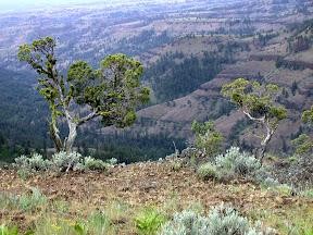
On September 3, 1964, President Lyndon B. Johnson signed into law the Wilderness Act. This historic bill established the National Wilderness Preservation System (NWPS) and set aside an initial 9.1 million acres of wildlands for the use and benefit of the American people. Over the past 50 years, and as a result of America's support for wilderness, Congress has added over 100 million acres to this unique land preservation system. The 1964 Wilderness Act defines "Wilderness" as areas where the earth and its communities of life are left unchanged by people, where the primary forces of nature are in control, and where people themselves are visitors who do not remain. Three unique designated wildernesses exist on the Umatilla National Forest. These areas radiate down into steep gorges and canyons from high plateaus. This unusual terrain offers a unique wilderness experience.
It is increasingly important to protect these areas and keep them healthy. Please review regulations associated with Wilderness areas and always use Leave No Trace techniques to help keep these areas wild, clean, and pristine.
Generally, a Wilderness has no roads, and all motorized or mechanized equipment is prohibited. Small, battery-powered, hand-held devices such as cameras and shavers are the only exceptions. Wheelchairs are allowed on a few trails wide enough for them because the chair is considered an extension of the disabled person's body.
Recreationists entering a Wilderness should expect a different type of experience. It is a primitive type of recreation and, as a result, conveniences such as tables, fire pits, and toilets are not appropriate. Trails within a wilderness are maintained to provide challenge.
Wilderness travel involves an element of risk. Visitors may be a long way from outside help if faced with an accident, illness, or other emergency. Recreationists should be prepared to be self-reliant by having the proper clothing and equipment and basic first-aid knowledge. Wilderness visitors should stay aware of changing weather conditions and other natural hazards. Risks can include forging creeks/rivers during high flow seasons particularly in the North Fork John Day Wilderness where primitive bridges are being phased out.
Wilderness is a place where we can examine the many complexities of our world. It serves as a research base to study unmodified ecosystems and the natural gene pool of plant and animal species. Each individual wilderness carries its own variety and breadth of diverse values.
Maps are available for each district on the Umatilla National Forest which include wilderness information. A specific map for the Wenaha-Tucannon wilderness is available. Maps are presented in topographical format and show major trail heads. Wilderness permits are not required, but visitors should leave their itinerary with a close friend or relative.
Umatilla National Forest Wilderness Areas
The Wenaha-Tucannon Wilderness in the northern Blue Mountains straddles the Oregon-Washington border. The Wenaha River, Crooked Creek, Rock Creek and Butte Creek have cut deep canyons into the tablelands and left heavily timbered "stringers" along the stream courses. The higher ridges are generally narrow with gravelly soils and very steep side slopes. Elevations within the Umatilla National Forest Wilderness areas range from 2,000 feet on the Wenaha River to 6,401 feet at Oregon Butte. Rocky Mountain elk, mule deer and whitetail deer inhabit the bunchgrass slopes on the Wenaha Canyon to the near-timberline species which grow on Oregon Butte and Table Rock.
The North Fork John Day Wilderness in the southeast section of the forest is laced by 130 miles of streams, many of which support anadromous fish. Its features include the bold granite outcroppings of the Greenhorn Mountains, heavily timbered streamside zones, grassland ridges and benches, and steep dissected canyons. The highest peaks on the forest are located in the Greenhorn Mountains near the Vinegar Hill-Indian Rock Scenic Area at the southern border of this Wilderness.
The forest's smallest wilderness, the North Fork Umatilla, is nestled in the narrow valley of the North Fork Umatilla River, 30 miles northeast of Pendleton. The river separates steep, timbered cliffs which rise to plateaus covered with native bunchgrass. The Wilderness supports elk and deer and is habitat for blue and ruffed grouse.
Explore a National Interactive Wilderness Map

View an interactive map of Wilderness areas of the United States and look for unique destinations near you.


