
Visitor Maps and Guides for the Calcasieu Ranger District, Vernon Unit
Visitors to the 85,000-acre Vernon Unit in Vernon Parish can enjoy the recreation serenity of a longleaf pine ecosystem and the historic past of Fullerton Lake Recreation Complex and the beauty of Little Cypress Recreation Complex. Fullerton Lake Recreation Complex was once the site of the Fullerton Sawmill and community, which was placed on the National Register of Historic Places in 1986. Ruins and foundations of the largest sawmill operation west of the Mississippi River may be seen on the 1.6-mile Fullerton Mill Trail. This trail is dotted with QR codes to allow visitors to enjoy a self-guided tour of this unique area. Fullerton Lake offers a variety of recreation options including camping, fishing, non=motorized boating, and a group-picnic shelter. Little Cypress Recreation Complex features a 3-acre spring-fed pond surrounded by the 0.5-mile, fully-accessible Ol' Sarge Interpretive Trail. Wolf Rock Cave may also be found on the Vernon Unit and is best described as two small rock overhangs overlooking Bundick's Creek. It is the only known rock shelter in Louisiana used by its early people, dating back to the Late Archaic time period, 2500-1000 BC.
Vernon Unit (Vernon Parish) Maps and Guides
Visitors to the 85,000-acre Vernon Unit in Vernon Parish can enjoy the recreation serenity of a longleaf pine ecosystem and the historic past of Fullerton Lake Recreation Complex and the beauty of Little Cypress Recreation Complex, as well as other beautiful recreational opportunities.
Vernon Unit Recreational Opportunities and Facilities Brochure
Twenty-two miles southeast of Leesville, lies over 30 miles of the Vernon Enduro Multiple-Use Trail. This trail loops through pine upland forest of western Louisiana and is also intersected frequently by the non-motorized Whiskey Chitto Trail for hikers, mountain bikes, and horseback riders.
NOTE: Trail status may change depending on the amount of rainfall in the area. You may call the OHV Hotline 24/7 at 318-473-7069 for the most recent updates. We do our best to keep information on the website and hotline current; however, there could be a delay in updating information. We apologize for any inconvenience this may cause. Typically, if a trail is open on Friday afternoon, it will remain open through that weekend. To confirm the status of a trail, please call the District office corresponding to the trail location. After hours, please call the OHV Hotline at 318-473-7069.
Visitors to Government Pond or the Hunter Camp off Forest Service Road 475, may enjoy hiking, mountain biking or horseback riding along the Big Branch and Wild Turkey Trails. These non-motorized use trails have two trailheads, one at Government Pond and the other at Hunter Camp. Currently there is a bridge out along the Big Branch Trail, resulting in a reroute. Please refer to this map for the current reroute.
Historic Fullerton Lake Recreation Complex was once the site of the Fullerton Sawmill and Town which was placed on the National Register of Historic Places in 1986. Ruins & foundations of one of the largest sawmill operations in the South may be seen on the 1.0 mile Sawmill Trail. Experience the thriving town as it once was as you explore the site, while stopping at interpretive signs along the trail. Enjoy picnicking, camping, fishing, hiking, non-motorized boating, and a group pavilion.
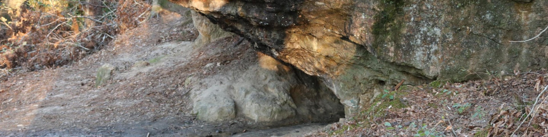
Directions: From HWY 171 in Pickering, LA take LA 10 going east for approx. 4.6 miles. Turn right at caution light onto LA 10 for approximately 1.7 miles. Turn right onto Forest Service Road 421 for approx. 0.1 mile. Turn left onto Forest Service Road 403 for approx. 2.3 miles. Wolf Rock Cave parking area will be on your right. The cave is located just a short distance from the parking area down a scenic trail along Bundick's Creek.
Rivers and streams flowing across broad coastal plains 24-30 million years ago (during the Oligocene period) deposited sediments making up the Catahoula Formation. The Catahoula formation, found in Louisiana, Mississippi, and Texas, consists of sandstones, sand, clays, and conglomerates. In Louisiana, the Catahoula Formation forms a belt across the central part of the state revealing that beaches and deltas were located 125 miles farther inland than today's coastline. This area is part of the Catahoula Formation and erosive processes created Wolf Rock Cave.
Wolf Rock Cave is best described as two small rock overhangs overlooking Bundick's Creek. It is the only known rock shelter in Louisiana used by its early people. It was used during the Late Archaic time period, and dates to 2500-1000 BC. It was used primarily as a lithic procurement area, in which the Archaic people collected chert from the area to make tools. There is also some evidence from the archaeological record that this area was used as a small habitation, that is some Archaic people lived here for short periods of time.
All people leave traces of their activities wherever they cook, build houses, hold religious ceremonies, make tools, or dump their trash. If these traces are undisturbed, archaeologists can use them to determine who left them, when they were left, and what activities were associated with them. Wolf Rock Cave is a true Louisiana treasure.
Ever wonder if that little dirt road is legal to drive on the National Forest? Here's a downloadable booklet to provide that information.
Calcasieu Ranger District Motor Vehicle Use Map (includes both Vernon and Evangeline Units)