






Morrison Area Trails
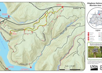
Morrison offers access to a variety of trail loop options, customizable for a day trip or extended backpacking experience. These trails are designated for hiking, biking, and cross-country skiing. On the map, the yellow highlighted trails indicate the only ski trails groomed periodically. Please yield to other trail users and avoid biking or hiking on groomed ski trails. Anglers may also enjoy fishing for native trout along the Morrison Run stream.
To the west, the system connects to the scenic Rimrock Overlook which provides outstanding views of the Allegheny Reservoir. The access road to the overlook is designated as a cross-country ski trail during the winter season.
No dispersed camping is allowed within 1,500 feet of the reservoir, except in designated areas. If you’re looking for a waterside campsite, the Morrison Boat Campground offers picnic tables, fire rings, and vault toilets for a fee.
Trailhead parking and a vault toilet are located along State Route 59. The system’s trails are marked with gray diamonds, with additional blue blazes to indicate ski trails.
Stay Safe
- Use caution along the reservoir and streams, the terrain includes steep hillsides with large boulders.
- Travel with at least one other person and leave your trip itinerary with a trusted individual.
- This trail is open for winter recreation; remember to dress in layers appropriate for the weather conditions.
- Be aware that this trail is heavily used by hunters in the late fall and springtime. Wearing bright fluorescent colored clothing, including blaze orange, is good practice during hunting seasons.
Active Alerts


Specific Trail Information
Trail Number
Trail Type
General Information
Keep Nature Natural
Leave No Trace Seven Principles
- Plan ahead and prepare: Choose appropriate equipment, clothing, and meals for comfort and safety.
- Travel and camp on durable surfaces: Good campsites are found, not made. Focus
usage on existing trails and campsites. - Dispose of waste properly: Pack it in, pack it out. Inspect your campsite and rest areas for trash or spilled food.
- Leave what you find: Leave nature and historic objects as you found them. Do not build structures.
- Minimize campfire impacts: Use available fire rings and put out campfires completely.
- Respect wildlife: Observe wildlife from a distance. Do not follow or approach them. Never feed animals.
- Be considerate of others: Avoid loud voices and noises. Yield to other users on the trail.
January - December

Address: 29 Forest Service Drive, Bradford, PA 16701
Phone: 814-362-4613
Hours: Monday to Friday: 8:30 am to 1:00 pm and 1:30 pm to 4:00 pm (Closed on federal holidays)
Getting There
Directions
From downtown Warren
- Travel south on Route 6/Crescent Park Drive for 2 miles.
- Turn left/east onto Route 59.
- Travel east on Route 59 for 13.5 miles.
- Trailhead is located on the right.
Additional Information
Operated By
USDA Forest Service
Recreation Opportunities


 Fishing - River/Stream
 Info
Fish for native trout stream on the back side of this 12.6 mile loop trail.
For information on fishing regulations and season visit the Pennsylvania Fish and Boat Commission website.


Geocaching & Letterboxing Info
Geo-caching is a permissible dispersed recreation activity on most areas of the Allegheny National Forest.
Areas where geocaching is not permitted include:
- Hickory Creek Wilderness,
- Tionesta Scenic and Research Natural Areas,
- Hearts Content Scenic Area and
- all developed recreation sites.
What You Need to Know About Geocaching:
- No soil disturbance is permitted for any geocache placement on the Forest.
- Caches should be covered with leaves or woody debris if the geo-cacher chooses to screen the cache at the site.
- We ask all geo-cachers to remove their cache if the site receives a large number of visits by others as evidenced by a well-worn trail or path.
- We ask that all caches be removed after one year regardless of site activity and moved to a new location or removed from the National Forest.
