
North Country National Scenic Trail and Trail Segments
North Country National Scenic Trail Through the Chippewa National Forest
The North Country National Scenic Trail passes through the Chippewa National Forest as part of the larger North Country National Scenic Trail. The trail travels over 4,600 miles from Crown Point, New York to Lake Sakakawea, North Dakota. Eventually the trail will link to the Appalachian Trail to the Lewis and Clark and Pacific Crest Trail. When completed, the North Country Trail will be the longest continuous foot path in the United States.
Within the Chippewa National Forest, the North Country National Scenic Trail meanders through 71-miles of forested lake country. White Pine forests and rivers overlook travelers along this scenic route. Each season harbors its own beauty along the Trail. In the spring, the Forest is dotted with wildflowers, morel mushrooms and the bright green of emerging aspen leaves. Summer brings wildlife, wild berries and northern lights. Autumn brings waves of reds, yellows and oak browns across the Forest, and winter brings a new opportunity for visitors: skiing, snowshoeing and winter camping.
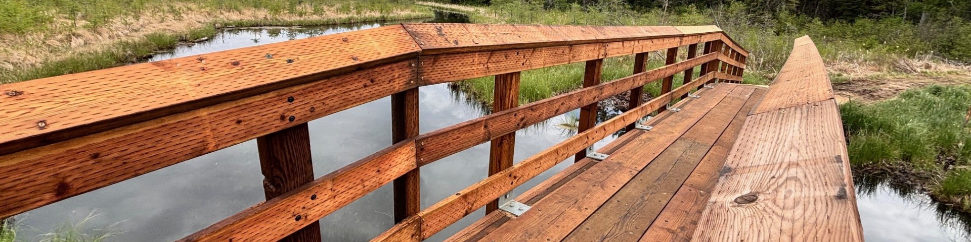
The new North Country National Scenic Trail Anway Trail Bridge is complete and open for hiking traffic! The Anway Bridge is south of Anway Lake crossing the flowage from Anway Lake to Shingobee River on the Chippewa National Forest.
For information on the North Country National Scenic Trail visit the National Park Service website or North Country Trail Association website.
Along the North Country Trail as you pass through the Chippewa National Forest:
Woodtick Fields:
Part of the Woodtick Trail this area is an example of the homesteaders who tried unsuccessfully to farm the area. The open fields, wind rows and old home sites are signs from the past. One family living along the Trail became the proud owners of a Model T, but unfortunately, had nowhere to drive it. The boys in the family were enlisted to grub out a roadway along the old railroad grade. The days were hot; the work was hard and buggy! The boys, tired of all the ‘ticks they were pulling off themselves, grimly nicknamed the area the “Woodtick Trail” and the name has… stuck!
Dispersed Camping:
You may camp anywhere on National Forest System land. When camping, choose a site away from the path to protect the trail's natural features. Primitive and dispersed campsites are located along the trail and are indicated on the map on the reverse side. These campsites are cleared; some provide fire rings, picnic tables and latrines.
Mabel Lake Campground:
The trail also passes near the Mabel Lake Campground which has 22 developed campsites, water, latrines, a boat ramp and swimming beach. When camping, use only dead and downed wood, pack out all that you pack in and treat all drinking water. Overnight parking is permitted at designated trailheads.

The North Country National Scenic Trail passes through the Chippewa National Forest as part of the larger North Country National Scenic Trail.

Lake Erin includes a picnic area and an interpretive trail around the lake. Various points of interest are marked along the one-kilometer (.6 miles) trail.

An earthen ramp, suitable for small boat trailers, provides access to the 131 acres of Hovde Lake. Hovde Lake is three miles south of MN Highway 200.

A concrete boat ramp provides access to the 243 acre Moccasin Lake. Moccasin Lake is along the Woodtick Trail in the Chippewa NF.
Located at 6715 Mable Lake Road NW Walker, MN 56484, 26 miles east of Walker on Highway 200.

Nestled along the rolling hills of the Shingobee River Valley, the Shingobee Recreation Area provides a variety of summer and winter activities.

As you travel the river and lakes of the Boy River Canoe Tour, take time to notice the changes in the Forest.