

Visitor Maps and Guides
Forest Service Digital Maps

Looking for a map to help plan your trip to a national forest or grassland? Click the link below to access free downloadable maps.
Forest Visitor Map

Forest Visitor maps are forest-specific maps that provide forest-wide information on attractions, facilities, services, and opportunities. They are professionally printed with tear and water-resistant paper. Available for purchase in print and digital.
Interactive Visitor Map

We have released the next-generation Interactive Forest Visitor Map! Map 2.0 provides the public with an online and mobile view of Forest Service roads, trails, recreation sites, wilderness areas, and wild and scenic rivers.
NEW 2025 Chippewa National Forest Visitor Map
- PDF version available at Avenza
- Mid-January, 2026 - Physical map for sale on the USGS Map Store and map available at all Chippewa National Forest offices.
Eastern Region Motor Vehicle Use Map Finder
The interactive map below provides links to download Motorized Vehicle Use Maps. Each map is represented by a box indicating its coverage area. Downloads are available in geospatial PDF format or through the Avenza Map Store.
To locate a map to download
- Use the dropdown menus to select a forest or ranger district. After selecting, the map will zoom to your choice.
- Pan and zoom around the map and find the extent of the map you want to download and select it.
- To pan, click/tap and drag around the map.
- To zoom, use your mouse’s scroll wheel, pinch to zoom, or use the +/- buttons on the map.
- Once selected, a popup will display for the map extent. This will contain links to download the map directly or in the map in the Avenza Maps store.
Note: more than one map may be selected when you click or tap an extent. Select/tap the arrows or use the select features menu at the bottom of the popup to toggle between selected extents.
Find your way around the Chippewa National Forest
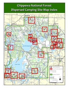
Blackduck Area Site Maps:
Deer River Area Site Maps:
- Deer River Area: Map 2
- Deer River Area: Map 3
- Deer River Area: Map 4
- Deer River Area: Map 5
- Deer River Area: Map 6
- Deer River Area: Map 7
- Deer River Area: Map 8
- Deer River Area: Map 9
- Deer River Area: Map 10
- Deer River Area: Map 11
- Deer River Area: Map 12
- Deer River Area: Map 13
- Deer River Area: Map 14
Walker Area Site Maps:
To locate Forest Service roads and trails a free Chippewa National Forest Motorized Vehicle Use Map (MVUM) is available showing numbered roads on the Forest open to OHVs. The map is available at national forest offices in Blackduck, Cass Lake, Deer River and Walker. The black and white MVUM is updated annually. Make sure you have the most recent version of the map.
The Chippewa National Forest map price is $14 and can be purchased at Forest Service offices in Cass Lake, Blackduck, Deer River and Walker.
There are three ways to order maps from the USGS:
- Online: USGS Store
- By phone: (406) 329-3024
- By U.S. mail:
USDA Forest Service | National Forest Store
P.O. Box 7669
Missoula, MT 59807
Digital maps for mobile applications can be downloaded at Avenza Maps. Digital maps cost $4.99 per side.
Additional online resources that may help users enjoy the great outdoors:
If you own a mobile device such as an iPad, iPhone, iPod Touch or Android (4.0.3 or newer), you can take the Chippewa National Forest Visitor Maps and Motor Vehicle Use Maps (MVUMs) with you.
With the app and maps installed on your mobile device, you will be able to:
- View your location on the PDF maps using the built-in GPS device
- Measure distances and areas
- Plot waypoints
- View maps offline
- And more…
Through a no-cost contract with Avenza Systems, Inc., the USDA Forest Service has made electronic versions of its Motor Vehicle Use Maps (MVUMs) available as free downloads for smartphones and tablets. The Forest Visitor map downloads are $4.99 each.
The above link does not imply an endorsement by the US Government of the product offered. It is merely offered as a convenience for users who may wish to install a free application on their smartphone.
The Chippewa National Forest Trails Data is now available to the public on the internet. You now have several options to find National Forest Trails:
- The interactive trail map is also available at the data.gov site at: https://data.gov/ enter “forest service trails” in search box and select ARCmap preview button
Transfer land parcels are located within the Leech Lake Band of Ojibwe Reservation and within Cass County, MN. The interactive map provides details on parcel locations. Use the display tools on the map to zoom and pan. The home icon will return you to the original view of the map.
link to: https://storymaps.arcgis.com/stories/85e4808064ec451193e843659e8c0641