





CC Wrangler Trailhead
This is southernmost of the five trailheads for the Ridge Runner National Recreation Trail.
From this trailhead visitors can continue to the 6-mile loop around North Fork Recreation Area or continue through on the Ozark Trail - North Fork and into Devils Backbone Wilderness Area.
Visitors heading north will hike for several miles before reaching Hay Hollow Trailhead.
Ridge Runner National Recreation Trail Details
Ridge Runner National Recreation Trail is a 33-mile long trail, with two six-mile loops at either end and a 21-mile section between them. The landscape varies from gently rolling to very steep terrain with rock outcrops and bluffs. There are a few creek crossings along the trail, no crossings have bridges so you may get your feet wet.
- Rating Moderate
- Length 33-miles
- Best Seasons Spring and Fall
- Surface Type unsurfaced, native material
- Average Trail Grade 8-20%
- Trail Markers there is limited trail marking
Ozark Trail - North Fork Section Details
For over 7 miles, from the Highway AP Trailhead (Blue Hole Trailhead) to CC Wrangler Trailhead, the trail is both Ozark Trail and Ridge Runner National Recreation Trail.
- Section Length: 27 miles
- Difficulty: Moderate
- Trail Surface: Unsurfaced, native material
- Average Trail Grade: 10-12%
- Best Seasons: Spring, Fall
- Going North/East: Eleven Point Section (not connected)
Devils Backbone Wilderness Trails
Thirteen miles of maintained foot and horse trails follow the Devils Backbone and four other ridges, dropping off into surrounding hollows in a forest dominated by oaks, hickories, and shortleaf pines.
The Ozark Trail overlaps with the McGarr and Collins Ridge Trailheads for three miles as part of the North Fork Section of the Ozark Trail.
- Rating Moderate
- Length 13-miles
- Best Seasons Spring and Fall
- Surface Type unsurfaced, native material
- Average Trail Grade 10-12%
- Trail Markers there is limited trail marking
- Elevation 680 feet to 1,020 feet
Active Alerts
General Information
Campground Camping
Trailer and tent camping at North Fork Recreation Area. All sites are first come, first served.
Dispersed Camping
- Hay Hollow Trailhead
- Noblett Lake Trailhead
- Noblett Trailhead
There is dispersed camping along the trail, please make camp at least 100 feet off of the trail. Dispersed camping is allowed at the old campground loop on the hill across from the Noblett Trailhead. There is also dispersed camping at CC Wrangler Camp.
Dispersed camping is the term used for free camping anywhere in the National Forest OUTSIDE of a designated campground. There are no toilets, no structures, no trash cans, no treated water, and no fire grates.
Safety:
- No drinking water is available at parking areas or along the trail; bring what you will need, or be prepared to sterilize water you find.
- During temperate months, be prepared for biting insects, poison ivy and high temperatures.
- Be aware of hunting seasons.
The Ozark climate is mild enough to make visits feasible throughout the year, as long as visitors bring proper gear. When possible, take advantage of this opportunity and plan your visit outside the peak spring and fall use seasons.
For more safety tips visit the Safety section of the website.
Private Property – Devils Back bone Wilderness is surrounded by private property. Please respect the rights and property of private landowners.
Available Maps:
- Ridge Runner, National Recreation Trail Map - PDF
- Devils Backbone Wilderness Map - PDF
- The Wilderness is located on the following quadrangle/topographic maps:
- Dora,
- Siloam Springs,
- Curea ll NW, and
- Pottersville
- The Wilderness is located on the following quadrangle/topographic maps:
Visit Visitor Maps and Guides for information on available Forest Visitor Maps, Topographic Maps, and Mobile App/Interactive Maps.
January to December
Day Use Hours:
- 6:00 AM to 10:00 PM
On the Trail
- Foot traffic, horse use and mountain bicycle use only.
- No motorized vehicles are allowed on the trail or past designated parking areas.
- Camping is allowed along the trail.
- Camp 100 feet away from trails, other camps, bluffs, caves, and water sources.
- Human waste (Feces) must be buried at least 6 inches deep and covered.
- Pack out all of your garbage, including cans, bottles, and other non-burnable items.
- Dogs are allowed on hiking trails, please ensure they are under control.
- Leashing is encouraged.
- Yield your leashed dog around other hikers, horses, or bikers.
- Pack out your dogs waste or bury it 100 feet from water and trails.
Trailheads
- No overnight camping in day use areas at any time of year.
- Dogs must be on a 6 foot leash in the day use area
- No trash containers; please pack out all your trash.
- Fireworks are prohibited.
Ridge Runner National Recreation Trail
- No permits are required for the Ridge Runner Trail.
Devils Backbone Wilderness Area
Self-Registration
There are three trailheads with sign in boxes at Devil’s Backbone Wilderness, at McGarr, Racoon, and Collins Ridge. Sign in sheets are recommended for all visitors, documenting hours in the wilderness, zip-code and party size.
Permits
- Commercial use will not be permitted in the wilderness.
- Special uses will not be permitted in the wilderness, except for access to surrounded private property.
North Fork Recreation Area Day Use Fees
Day Use Fees can be paid on-site using the provided fee tubes.
- Fees must be paid using cash or check, no credit card machines are available at any sites.
- Annual and Lifetime passes can be purchased to cover day use fees at USDA Forest Service operated sites.
No fees are required for this site
Trail Use
Dogs are allowed on hiking trails. Please leash your dog, unleashed dogs can pose a danger to your pet, the natural resources of the area, and other forest visitors.
- Leashes must be six feet, or shorter, when in developed recreation sites, including trails within the boundaries (36 CFR 261.16(j)) when they are not inside an enclosed vehicle or tent.
- Yield your leashed dog around other hikers and horses.
- Pack out your dogs waste or bury it 100 feet from water and trails.
Camping
- Keep dogs on a six-foot, or shorter, leash when they are not inside a tent.
- Store dog food in bear-resistant containers and feed your pet away from the campsite.
- Pick up and bag your dog’s waste. Place it in a provided trash receptacle or pack it out.
- Do not leave your dog unattended at any time.
- Do not leave your dog in the vehicle on a hot day.
- Keep your dog in your tent or vehicle at night.
- Ensure that there is ample water available for your pet.
Wildlife
- Do not allow them to interact with wildlife

Address: 1006 S. Jefferson Ava, MO 65608
Phone: 417-683-4428
Hours: 8:00 am - 4:30 pm, Monday to Friday; District Offices closed 1 - 1:30 for lunch (Closed on federal holidays)
Office Email: sm.fs.marktwainnf@usda.gov
Getting There
Latitude / Longitude
Latitude: 36.762097
Longitude: -92.128639
Directions
From Dora
- Take County Road CC for 5.9 miles.
- The trailhead will be on the left.
From West Plains
- Take State Route CC and State Highway CC to County Road CC for 16.3 miles.
- The trailhead will be on the right.
Parking
Parking is available.
Facility and Amenity Information
Restrooms
No restroom availableHorse/Pack Animal Information
Horse/Pack animals are allowed at this site.
Horses
- may not be tied directly to trees.
- No horses allowed in the day use areas at Noblett and North Fork or on the children’s trail portion near Blue Springs.
Nearby Trails
- Ridge Runner National Recreation Trail
- Ozark Trail - North Fork Section
- Devils Backbone Wilderness Trail
Recreation Opportunities


Recreation Groups
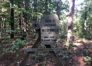
Visit the land where a steep, narrow, ridge drops away, plunging into deep hollows. Welcome to Devils Backbone Wilderness Area.
Ridge Runner National Recreation Trail is a 33-mile long trail, with two six-mile loops at either end and a 21-mile section between them.

The areas listed below are not only easy to get to, but most are known locations for good birding.
These sites were selected because they have: