

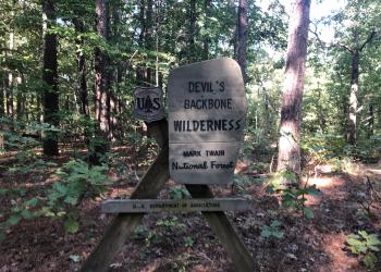
Devils Backbone Wilderness
Visit the land where a steep, narrow, ridge drops away, plunging into deep hollows. Welcome to Devils Backbone Wilderness Area.
The area draws its name from a quarter mile long stretch of trail where the sides of the ridge fall away 10 feet from the path on either side.
With 6,687 acres inside the Wilderness boundary, this is an ideal area for day hiking or overnight backpacking. A long, narrow ridge supports the center of the Wilderness, with 1,020 feet as its highest “vertebra.”
Trails
There are 13 miles of moderate trail within the area.
Thirteen miles of maintained foot and horse trails follow the Devils Backbone and four other ridges, dropping off into surrounding hollows in a forest dominated by oaks, hickories, and shortleaf pines.
The Ozark Trail overlaps with the McGarr and Collins Ridge Trailheads for three miles as part of the North Fork Section of the Ozark Trail.
Devils Backbone Wilderness Area Trails
- Rating Moderate
- Length 13-miles
- Best Seasons Spring and Fall
- Surface Type unsurfaced, native material
- Average Trail Grade 10-12%
- Trail Markers there is limited trail marking
- Elevation 680 feet to 1,020 feet
Trail Sections/Segments
- Mary Hollow to Collins Ridge - 1.382 miles
- Collins Trailhead to McGarr Ridge - 2.71 miles
- McGarr Ridge (section 13) to McGarr Ridge (section 14) - 4.15 miles
- CC Highway to North Fork River - 6.33 miles
Terrain and Topography
After severe flooding in Missouri’s southeast in 2017, portions of Devil’s Backbone’s trails were washed out completely. Water from the North Fork River reached unprecedented heights, in some places debris exceeded 31 feet into the tree line.
The North Fork River stretches over 67 miles from Wright County until it joins the White River and flows into Arkansas. In the middle of its journey, it crosses ~1.5 miles of Devil’s Backbone Wilderness. The river’s flow is fed by Blue, McGarr and Amber Springs within the Wilderness Area.
Vegetation and Wildlife
Wildlife
Scattered limestone glades and other openings provide some of the more favorable places to view wildlife.
Bald eagles have been seen along the corridor, and in recent years nests have been spotted within the Wilderness.
White-tailed deer, gray squirrel, raccoon, coyote, red and gray fox, bobcat and striped skunk are some of the mammals native to the area.
Wild turkey, red-tailed hawk, great horned owl, bald eagle, turkey vulture, great blue heron, pileated woodpecker and various songbirds can be seen.
Among the reptiles common to the area are two poisonous snakes, the copperhead and the eastern timber rattler.
Vegetation
Dogwood, redbud and wild azaleas give the wilderness a wild burst of color in the spring. Fall isn’t to be outdone when the oaks, sweet gum, and sugar maple put on a show of yellow, oranges and reds.
Along the valleys and understories, a variety of vegetation exists, including an abundance of smaller trees, shrubs, grasses, and herbaceous plants.
Scattered in the forest are gaps of limestone glades where insect and vascular plant diversity thrives. Here the tree cover opens up as soils become thin and light. Juniper and pine cannot dig a hold into the exposed rock, but flowering forbs and dry grasses thrive.
Where the slopes drop off into the North Fork River, wild azaleas bloom.
Wilderness Area History
Before the Devil’s Backbone Wilderness was established, there were backcountry settlements, logging camps and livestock grazing. When the Forest Service acquired the land it inherited the history of this legacy as well. Now, when hiking on its trails, one can find vestiges of these settlements- mine shafts nestled in between rocks, abandoned grazing pastures and a skeleton network of old roads which nature is slowly reclaiming.
Occasionally the trail is flanked by ruins of old rock walls used to herd sheep, and in places the trail so wide that one can practically feel the rumble of logging trucks which used to cross it. These abandoned roads form the basis for Norfolk Ridge and many of the unofficial trails hikers travel as they journey beyond the maintained portion of the Wilderness.
Early settlers who came to this land tried to eke out a living by clearing parts of the forest for pasture and grazing. Long after they gave up on taming the forest, the boney ridge was harvested during the logging fervor of the 1890’s. Large tracks of land were cut down and logs floated down the North Fork to meet the White River down below.
Today, this history is reflected in the age and composition of the existing tree stands. After the pine canopy was cut, oaks and hickories bounced back and quickly rose to take the place of the towering shortleaf pines, forming a heavy forest cover of an oak-hickory ecosystem. However, these groves contain many individuals who all will age at the same time and stage, contributing to a forest-wide phenomena of oak decline.
Photos of Devils Backbone Wilderness Area


Active Alerts
General Information
Camping
North Fork Recreation Area locally known as Hammond Camp adjoins the north edge of the wilderness and provides quality camping and picnic opportunities. There is a designated canoe launch in this Recreation Area.
Dispersed camping is allowed along the trail. There are no toilets, no structures, no trash cans, no treated water, and no fire grates available.
Safety:
- During temperate months, be prepared for biting insects, poison ivy and high temperatures.
- A good map and compass , along with knowledge of utilizing these, are strongly suggested.
- Be aware of hunting seasons.
- Avoid using the trail during excessively wet periods.
- Be sure to tell someone your plans,
- don’t hike the wilderness alone and
- carry extra supplies so you are prepared to take care of yourself in case you get lost, injured, or delayed.
- The universal distress signal is three of anything: shots, shouts, smokes, whistles.
The Ozark climate is mild enough to make Wilderness visits feasible throughout the year, as long as visitors bring proper gear. When possible, take advantage of this opportunity and plan your visit outside the peak spring and fall use seasons.
For more safety tips visit the Safety section of the website.
Available Maps:
- Devils Backbone Wilderness Map - PDF
- Trail System Map available on the Avenza app.
- The Wilderness is located on the following quadrangle/topographic maps:
- Dora,
- Siloam Springs,
- Curea ll NW, and
- Pottersville
Visit Visitor Maps and Guides for information on available Forest Visitor Maps, Topographic Maps, and Mobile App/Interactive Maps.
Private Property – Devils Back bone Wilderness is surrounded by private property. Please respect the rights and property of private landowners.
January - December
Campgrounds:
- Open 24 Hours a day to campers.
- Quiet Hours: 10:00 PM to 6:00 AM
Day Use Areas and Trailheads Hours:
- 6:00 AM to 10:00 PM
Wilderness
- No motorized vehicles are allowed on the trail or past designated parking areas.
- Camping is allowed along the trail.
- Camp 100 feet away from trails, other camps, and water sources.
- Human waste (Feces) must be buried at least 6 inches deep and covered.
- Pack out all of your garbage.
- Stock: never tie stock directly to trees.
- Limit your party size to 10 persons
- Practice Leave No Trace outdoor ethics;
Trailheads
- No overnight camping in day use areas at any time of year.
- Dogs must be on a 6 foot leash in the day use area
- No trash containers; please pack out all your trash.
- Fireworks are prohibited.
Self-Registration
There are three trailheads with sign in boxes at Devil’s Backbone Wilderness, at McGarr, Racoon, and Collins Ridge. Sign in sheets are recommended for all visitors, documenting hours in the wilderness, zip-code and party size.
Permits
- Commercial use will not be permitted in the wilderness.
- Special uses will not be permitted in the wilderness, except for access to surrounded private property.
North Fork Recreation Area Day Use Fees
Day Use Fees can be paid on-site using the provided fee tubes.
- Fees must be paid using cash or check, no credit card machines are available at any sites.
- Annual and Lifetime passes can be purchased to cover day use fees at USDA Forest Service operated sites.
There are self-registration stations at each wilderness trailhead entrance. Overnight and day use visitors are requested to register.
Trailheads with Fees:
- Blue Spring Trailhead (in North Fork Recreation Area)
Trail Use
Dogs are allowed on hiking trails. Please leash your dog, unleashed dogs can pose a danger to your pet, the natural resources of the area, and other forest visitors.
- Leashes must be six feet, or shorter, when in developed recreation sites, including trails within the boundaries (36 CFR 261.16(j)) when they are not inside an enclosed vehicle or tent.
- Yield your leashed dog around other hikers and horses.
- Pack out your dogs waste or bury it 100 feet from water and trails.
Camping
- Keep dogs on a six-foot, or shorter, leash when they are not inside a tent.
- Store dog food in bear-resistant containers and feed your pet away from the campsite.
- Pick up and bag your dog’s waste. Place it in a provided trash receptacle or pack it out.
- Do not leave your dog unattended at any time.
- Do not leave your dog in the vehicle on a hot day.
- Keep your dog in your tent or vehicle at night.
- Ensure that there is ample water available for your pet.
Wildlife
- Do not allow them to interact with wildlife

Address: 1006 S. Jefferson Ava, MO 65608
Phone: 417-683-4428
Hours: 8:00 am - 4:30 pm, Monday to Friday; District Offices closed 1 - 1:30 for lunch (Closed on federal holidays)
Office Email: sm.fs.marktwainnf@usda.gov
Getting There
Elevation
1,020
Directions
Four trailheads provide entry to Devil's Backbone Wilderness:
From Dora
- Raccoon Hollow Trailhead is located on the south side of CC Highway about 1 1/2 miles east of Dora, MO;
- McGarr Ridge Trailhead is located on the south side of CC Highway about 4 miles east of Dora, MO; and
From West Plains
- Blue Spring Trailhead is located within the North Fork Recreation Area (no horses allowed on this short section)
- Collin's Ridge Trailhead is located on County Road KK 362 which comes off KK Highway about 16 miles west of West Plains, MO on the south side of the wilderness.
Parking
Four trailheads provide entry to Devil's Backbone Wilderness that have parking:
- Blue Spring Trailhead: 12 vehicles
- Raccoon Hollow: up to 3 cars can fit at this trailhead
- McGarr Ridge: up to 3 cars can fit at this trailhead.
- Collins Ridge Trailhead: 3 trucks with horse trailers and a couple additional cars
Facility and Amenity Information
Restrooms
There is a vault toilet available at Blue Spring Trailhead in the North Fork Recreation Area.
Water
Potable water is not available at this site.
No water is available at Collins Ridge, Racoon Hollow, or McGarr Ridge Trailheads.
Water is available within the North Fork Recreation Area.
Drinking water is not available in Devils Backbone Wilderness, open water sources within the wilderness are not recommended for drinking. Bring your own drinking water or be prepared to boil or treat water chemically.
Picnic Tables
Picnic tables are not available at this site.
North Fork Recreation Area/Blue Spring Trailhead: There are 4 sites for day use picnicking with grills and tables.
Horse/Pack Animal Information
Horse/Pack animals are allowed at this site.
No horses are allowed on the Blue Spring Trail that connects to the Devils Backbone Wilderness Area.
Nearby Trails
- Ozark Trail - North Fork Section
- Ridge Runner National Recreation Trail
- Devils Backbone Wilderness Trail
- Blue Spring Trail
Recreation Opportunities
Day Hikes Info
Trailheads
- Collins Ridge Trailhead
- McGarr Ridge Trailhead
- Raccoon Hollow Trailhead
- Blue Spring Trailhead (North Fork Recreation Area)
When traveling on a trail, stay on the trail. When traveling cross-country use your map and compass. Use of blazes, ribbons or other trail markers should be avoided; let the next fellow find his own way as you did.
Remember saddle and pack stock have the right-of-way on trails. Give way to them and avoid conflicts and possible accidents.
Backpacking Info
Trailheads
- Collins Ridge Trailhead
- McGarr Ridge Trailhead
- Raccoon Hollow Trailhead
- Blue Spring Trailhead (North Fork Recreation Area)
When traveling on a trail, stay on the trail. When traveling cross-country use your map and compass. Use of blazes, ribbons or other trail markers should be avoided; let the next fellow find his own way as you did.
Remember saddle and pack stock have the right-of-way on trails. Give way to them and avoid conflicts and possible accidents.
Backpackers should leave no sign of their presence so that the next person can enjoy natural scenes and solitude. You must tread lightly so nature can endure and replenish.
- Trail Length: 13 miles
- Trail Surface Type: Unsurfaced, native material.
Terrain: Terrain is sometimes steep. Elevations range from 680 to 1,020 feet.
Best Seasons: Fall, winter, and spring.
Horseback Riding Info
Trailheads
- Collins Ridge Trailhead
- McGarr Ridge Trailhead
- Raccoon Hollow Trailhead
- Blue Spring Trailhead (North Fork Recreation Area)
Don't tie saddle and pack stock to trees as the rope rubbing and concentrated animal tramping will injure and eventually kill the vegetation.
It' s better to hobble or tie a rope between two large trees and use it as a hitch rail.
When breaking camp, scatter manure and smooth up the area.
Avoid prolonged stock grazing in one area; it can have a serious impact on vegetation. Bring concentrated supplement stock feed to help reduce this impact.
Picket your stock at least 200 feet away from waterways, trails, or camps
Recreation Groups
Visit the land where a steep, narrow, ridge drops away, plunging into deep hollows. Welcome to Devils Backbone Wilderness Area.
Ridge Runner National Recreation Trail is a 33-mile long trail, with two six-mile loops at either end and a 21-mile section between them.