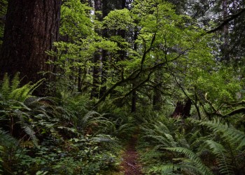
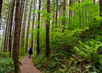
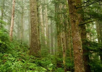
Recreation
Stretching from the lush forests of the coastal mountains to the unique Oregon Dunes and on into the beaches of the Pacific Ocean, visitors have a stunning choice of opportunities. One can find activities to suit every taste: from spectacular mountain views to beach combing, from whale watching to exploring the forest or dunes, the Siuslaw National Forest offers something for everyone.
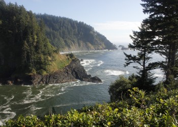
 Highlights include great views, old growth forests, guided hikes, waterfalls, miles of sand dunes to explore, and much more!
Download our Pocket Guide to the Siuslaw National Forest in English or en Español or download our camping, hiking, and day use brochure here.
Current Recreation Conditions
| Area Name | Status | Area Conditions |
|---|---|---|
| Alder Dune Campground | Open | 8/1/2024: Open |
| Alder Dune Day Use (Dune Lake) | Open | |
| Alder Dune Trails #1322 | Open | 11/19/2024: Trails are open. Expect seasonal flooding and storm debris on trails during Winter months. |
| Amanda's Trail #1386 | Open | 11/20/24: Trail is open. |
| Archie Knowles Campground | Open | Contact Lane County Parks |
| Baker Beach Campground | Open | Snowy Plover restrictions in place March 15 - September 15 |
| Baker Beach Trail #1368 | Open | 11/19/2024: Trails have been maintained 2024. Expect storm debris on trails during Winter months.Snowy Plover restrictions in place March 15 - September 15 |
| Baker Beach Trailhead | Open | Snowy Plover restrictions in place March 15 - September 15 |
| Battle Lake Trail #1302 | Open | |
| Battle Lake Trailhead | Open | Watch for potholes and debris in road. |
| Big Elk Campground | Open | Operated by local community under special use permit. Open with limited services. |
| Blackberry Boat Ramp & Day Use | Open | |
| Blackberry Campground | Open | |
| Bluebill Campground | Closed | Snowy Plover restrictions in place March 15 - September 15 All campsites in ODNRA now require a digital reservation and payment. |
| Bluebill Trailhead | Open | |
| Breach OHV Trail | Open | 11/25/24: There has been a significant amount of rainfall this fall that has been contributing to early flooding. Please drive careful and call ahead if you are concerned about flooding on your stay. If you are planning on using the sand while here, there is significant flooding in the routes, access points, and riding area. Please use caution in your travels. |
| Bull Run OHV Staging Area | Open | |
| Canal Creek Group Campground | Open | 5/15/24: The Canal Creek Bridge that connects the two group campsites is closed. |
| Cape Cove Trail #1364.1 | Temporarily Closed | 8/19/2024: A 300-foot section of Cape Cove Trail #1364.1, the trail that connects the Captain Cook Trail to the Restless Waters Trail and is adjacent to Hwy 101, is temporarily closed due to erosion and dangerous conditions. Cape Cove Beach trail is still accessible from Devils Churn or the small parking area near Cape Cove Beach. The trail will reopen once major repairs are complete. See map for details. |
| Cape Cove Trailhead | Temporarily Closed | 8/19/24: A 300-foot section of Cape Cove Trail #1364.1, the trail that connects the Captain Cook Trail to the Restless Waters Trail and is adjacent to Hwy 101, is temporarily closed due to erosion and dangerous conditions. Cape Cove Beach trail is still accessible from Devils Churn or the small parking area near Cape Cove Beach. The trail will reopen once major repairs are complete. See map for details. |
| Cape Mountain Trails #1329 | Open | 11/18/2024: Trails are open & have been maintained summer 2024. Some downed logs have been reported, so far all seem to be passible. Expect seasonal storms to drop more debris and trees on trails during Winter months. |
| Cape Perpetua Campground | Closed | |
| Cape Perpetua Group Campground | Closed | |
| Cape Perpetua Overlook Day Use | Open | |
| Cape Perpetua Scenic Area | Open | Open for day use 6am-10pm. |
| Cape Perpetua Trailhead | Open | |
| Cape Perpetua Visitor Center | None | Winter Hours: Open 10:00am to 4:00pm Tuesday - Sunday. Closed Monday. |
| Captain Cook Trailhead | Open | 8/1/2024: Trail is open. |
| Carter Dunes Trail #1384 | Open | Snowy Plover restrictions in place March 15 - September 15 |
| Carter Dunes Trailhead | Open | Snowy Plover restrictions in place March 15 - September 15 |
| Carter Lake Boat Ramp | Open | Snowy Plover restrictions in place March 15 - September 15 |
| Carter Lake Campground | Closed | Snowy Plover restrictions in place March 15 - September 15 All campsites in ODNRA now require a digital reservation and payment. |
| Carter Lake Day Use | Closed | Snowy Plover restrictions in place March 15 - September 15 |
| Cascade Head Scenic Research Area | None | Due to a landslide in 2021, Forest Road 1861, which accesses the Rainforest Trail #1310 - Road 1861 Trailhead, Hart’s Cove Trail #1303 and Hart’s Cove Trailhead, is closed to vehicle traffic from Hwy 101. The landslide washed out a section of the road approximately half a mile from Highway 101, creating impassable conditions. Hart’s Cove Trailhead can be accessed by hiking the Rainforest Trail #1310. Tillamook County emergency response is limited in the Cascade Head area due to restricted access to FSR 1861 and cell service is limited. See map for details. |
| Castle Rock Group Campground | Open | |
| Chapman's OHV Trail | Open | |
| Chief Tsiltcoos Trail #1359 | Open | 11/19/2024: Trail open. Maintained Summer 2023. No recent reports. Expect storm debris on trails during Fall-Winter months. Snowy Plover restrictions in place March 15 - September 15 |
| Coast Guard North OHV Trail | Open | |
| Conner's Camp Day Use | Open | Conner's Camp is a day use site and overnight camping is prohibited. |
| Conner's Camp Trailhead | Open | |
| Cummins Creek Loop Trail #1382-A | Open | Bikes allowed on Cummins Creek Loop. |
| Cummins Creek Trail #1382 | Open | Bikes allowed on Cummins Creek Loop. Expect storm debris on trails during Fall and Winter months. |
| Cummins Creek Trailhead | Open | |
| Cummins Creek Wilderness | Open | 11/19/24: Trail is open. No recent reports. No Horses, Bikes or OHV allowed inside Wilderness. Pack it in pack it Out. |
| Cummins Ridge Trail - East Trailhead | Open | |
| Cummins Ridge Trail - West Trailhead | Open | 11/19/24: Trail Open. |
| Derrick Road Dispersed Camping Area | Open | |
| Devils Churn Day Use | Open | The information window is staffed June-September from Fridays through Sundays, 10:00 a.m. - 3:00 p.m. |
| Devil’s Staircase Wilderness | Open | No trails are present; navigation and travel is challenging year-round. Search & rescue can take many hours or even days to access lost hikers. |
| Discovery Loop Trail #1387 | Open | 11/19/2024: Trail is open. Expect storm debris on trails during Winter months. |
| Drift Creek Falls Trail #1378 | Open | 11/27/24: Forest Road 17 is open. |
| Drift Creek Falls Trailhead | Open | 11/27/24: Forest Road 17 is open. |
| Drift Creek Wilderness | Open | No Bikes, or motorized vehicles allowed. |
| Driftwood II Campground | Open | 11/25/24: There has been a significant amount of rainfall this fall that has been contributing to early flooding. Please drive careful and call ahead if you are concerned about flooding on your stay. If you are planning on using the sand while here, there is significant flooding in the routes, access points, and riding area. Please use caution in your travels.
Snowy Plover restrictions in place March 15 - September 15 All campsites in ODNRA now require a digital reservation and payment. |
| Driftwood II OHV Trail | Open | 11/25/24: There has been a significant amount of rainfall this fall that has been contributing to early flooding. Please drive careful and call ahead if you are concerned about flooding on your stay. If you are planning on using the sand while here, there is significant flooding in the routes, access points, and riding area. Please use caution in your travels. |
| Dry Lake Horse Camp | Open | 8/28/24: Vault toilet is out of order. Trailhead is open. Forest Road 789 has not been maintained recently and may not be suitable for trailers or large campers. No water, trash service or fees. Please pack out your trash. |
| East Dunes Campground | Temporarily Closed | 7/30/24: The campground is expected to temporarily close in September for road maintenance. |
| East Ridge Trail #1324 | Open | 8/1/2024: East Ridge, North Ridge and Tie Trails are seasonally OPEN to Bikes May 15 through Oct. 15. |
| Eel Creek Campground | Open | 10/16/24: South loop is closed, main loop is open. All campsites in ODNRA now require a digital reservation and payment. |
| Enchanted Valley Trail #1321 | Open | 8/1/2024: Trail is open. |
| Enchanted Valley Trailhead | Open | Mercer Lake Road to Twin Fawn Drive to access trailhead. Use caution on narrow blind curve road! |
| Ermie Walters Boat Launch | Open | |
| Fisherman's Day Use | Open | |
| Giant Spruce Trail #1365 | Open | 11/19/2024: Trail is open. Expect storm debris on trails during Winter months. |
| Goosepasture OHV Staging Area | Open | |
| Goosepasture OHV Trail | Open | |
| Gwynn Creek Trail #1371 | Open | 11/19/2024: Trail is open. Expect storm debris on trails during Winter months. Report any trail issues to District Trail Coordinator: 541-997-2562. |
| Hall & Schuttpelz Lake Trail #1357 | Open | 11/19/2024: Trails are open. Expect storm debris on trails during Winter months. |
| Hall & Schuttpelz Lakes Day Use | Open | 11/19/2024: Trail is open. Report any issues to Trails Coordinator: 541-997-2562 |
| Harris Ranch Trail #1347 | Open | 8/22/2024: Trail is open. First 1.5 miles of trail has been maintained. Several logs down and brushy, but trail is passible. Please practice leave no trace - pack out what you pack in. No bikes or motorized equipment allowed in Wilderness. |
| Harris Ranch Trailhead | Open | |
| Hart's Cove Trail #1303 | Closed | Due to a landslide in 2021, Forest Road 1861, which accesses the Rainforest Trail #1310 - Road 1861 Trailhead, Hart’s Cove Trail #1303 and Hart’s Cove Trailhead, is closed to vehicle traffic from Hwy 101. The landslide washed out a section of the road approximately half a mile from Highway 101, creating impassable conditions. Hart’s Cove Trail #1303 can be accessed by hiking the Rainforest Trail #1310. Tillamook County emergency response is limited in the Cascade Head area due to restricted access to FSR 1861 and cell service is limited. See map for details. There is a seasonal area closure from January 1 to July 15 to protect sensitive nesting habitat. During this time, please do not hike on any roads, trails, or off-trail areas on National Forest lands north of the Salmon River. The exception is The Rainforest Trail, which remains open to hiking use year-round. This seasonal closure does not apply to lands managed by The Nature Conservancy. |
| Hart's Cove Trailhead | Closed | Due to a landslide in 2021, Forest Road 1861, which accesses the Rainforest Trail #1310 - Road 1861 Trailhead, Hart’s Cove Trail #1303 and Hart’s Cove Trailhead, is closed to vehicle traffic from Hwy 101. The landslide washed out a section of the road approximately half a mile from Highway 101, creating impassable conditions. Hart’s Cove Trailhead can be accessed by hiking the Rainforest Trail #1310. Tillamook County emergency response is limited in the Cascade Head area due to restricted access to FSR 1861 and cell service is limited. See map for details. There is a seasonal area closure from January 1 to July 15 to protect sensitive nesting habitat. During this time, please do not hike on any roads, trails, or off-trail areas on National Forest lands north of the Salmon River. The exception is The Rainforest Trail, which remains open to hiking use year-round. This seasonal closure does not apply to lands managed by The Nature Conservancy. |
| Hauser Sand Camping | Open | All campsites in ODNRA now require a digital reservation and payment. |
| Hebo Lake Campground | Closed | This campground is reservation only. Use the Recreation.gov app and scan the QR code for first come, first served sites. |
| Hebo Lake Day Use | Open | No cash accepted for day use fee. Purchase a recreation pass or permit before you visit. Passes and Permits Link |
| Hebo Lake Loop Trail #1311 | Open | |
| Heceta Lighthouse Trail #1370 | Open | |
| Holman Vista Day Use | Open | Snowy Plover restrictions in place March 15 - September 15 |
| Holman Vista Trail #1326 | Open | Reports of cougar & bear activity in the area in 2021. Keep pets on leash. |
| Horse Creek Campground | Open | 11/14/24: Forest Road 789 has not been maintained recently and may not be suitable for trailers or large campers. No water, trash service or fees. Please pack out your trash. Horse campgrounds are designed to accommodate people who need to corral their horses. We have a limited number of these kinds of campgrounds and ask, out of courtesy and safety for you and the horses, to consider camping in a different campground if you do not have a horse |
| Horse Creek North Trailhead | Open | 8/22/2024: Trail is open. first mile of trail has been brushed and logged out. The remaining portion in the Wilderness has not been scouted recently. Expect potential logs down on trail and brushy patches. |
| Horse Creek South Trailhead | Open | 8/22/2024: Trail is open, and has been brushed out. Trail has been logged out for the first 3 miles. Still several logs down on lower end, but trail is passible in current condition. |
| Horsfall Beach Campground | Open |
Snowy Plover restrictions in place March 15 - September 15 All campsites in ODNRA now require a digital reservation and payment. |
| Horsfall Beach Day Use OHV Staging | Open | |
| Horsfall Campground | Open | All campsites in ODNRA now require a digital reservation and payment. |
| Horsfall Day Use OHV Staging | Open | |
| Horsfall Sand Camping | Open | All campsites in ODNRA now require a digital reservation and payment. |
| Hunters OHV Trail | Open | |
| Incinerator OHV Trail | Open | |
| John Dellenback Dunes Trail #1339 | Open | Snowy Plover restrictions in place March 15 - September 15 |
| John Dellenback Dunes Trailhead | Open | Snowy Plover restrictions in place March 15 - September 15 |
| Kentucky Falls Trail #1376 | Open | 11/19/2024: Trail was maintained 2024, and is open from Trailhead to the lower Kentucky Falls. Be prepared for Winter conditions and expect storm debris on trail. There is some downed trees and brushy areas between Lower Kentucky Falls for 2.5 miles on North Fork Smith River Trail, but the trail is passible. Use caution if hiking in the area. *Caution: Kentucky Falls and NF Smith River Trails are remote without facilities. Trails are moderate to difficult. Plan ahead for steep uneven sections by bringing a map and compass, extra water and food & raingear. |
| Kentucky Falls Trailhead | Open | 11/19/2024: Roads are open, but recent storm debris may be down. Use caution when driving on wet leaves. Be prepared for winter conditions. |
| Lagoon Campground | Open | Snowy Plover restrictions in place March 15 - September 15 All campsites in ODNRA now require a digital reservation and payment. |
| Lagoon Loop Trail #1330 | None | 11/19/2024: Trail open year round. Expect some local flooding and storm debris during winter months. |
| Lagoon Trailhead | None | Open |
| Lodgepole Picnic Area | Open | |
| Mapleton Hill Pioneer Trailhead | Open | 8/1/2024: Trail open. |
| Marys Peak | Open | 11/20/2024: Bikes allowed on trails May 15 through Oct. 15. |
| Marys Peak Campground | Closed | Closed for the 2024 season. Will reopen in spring 2025. |
| Marys Peak Day Use | Open | |
| Mercer Lake Boat Ramp | Open | Contact Lane County Parks |
| Mike Bauer Wayside | Open | |
| Mt Hebo Horse Trailhead | Open | |
| Niagara Falls Trail #1379 | Open | |
| Niagara Falls Trailhead | Open | |
| Noel Ranch Boat Launch | Open | |
| North Fork Siuslaw Campground | Closed | 10/1/2024:CLOSED. |
| North Fork Smith Trail #1351 | Open | 11/19/2024: Trail was maintained Summer 2024 for the first 4 miles from the NF Smith TH.+ the small nature loop. Expect Fall/Winter storm debris on the trail & be prepared for Winter conditions. *Caution: NF Smith River trails is in a remote setting with steep sections and uneven surface. Plan ahead and use caution by carrying extra water, food and warm clothing & Map and compass. |
| North Fork Smith Trailhead | Open | 11/19/2024: Road open between Reedsport and NF Smith TH. 48 Rd is passible between Sweet Creek and 23 Rd. to NF Smith TH. Expect storm debris on roads during Fall/Winter months. Be prepared for snow conditions. |
| North Ridge Trail #1350 | Open | 8/1/2024:Open to Bikes between May 15, 2023 through Oct. 15, 2024. |
| Ocean Beach Day Use | Open | |
| Old Bark Road OHV Staging Area | Open | 8/19/24: The OHV staging area is currently open, but sand camping may be impacted by high water. Before heading to the ODNRA, please give our front desk a call for the most updated information about site closures at 541-271-6000. Do not attempt to drive through standing water as it could be deeper than it appears. |
| Oregon Dunes Loop Trail #1334 | Open | 11/20/2024: Dune Loop trail is open & has been brushed and maintained for 2024. Expect storm debris on trails during Winter months. Snowy Plover restrictions in place March 15 - September 15 |
| Oregon Dunes National Recreation Area | Open | Confirm specific site on the ODNRA is open before heading out. Beach access limited March 15 - Sept 15 to protect Snowy Plovers All campsites in ODNRA now require a digital reservation and payment. |
| Oregon Dunes National Recreation Area Office | Open | |
| Oregon Dunes Overlook and Day Use | Open | Visitors can purchase a digital day pass online. No cash accepted.
Snowy Plover restrictions in place March 15 - September 15 |
| Pawn Trail #1317 | Open | Trail is open. Loop trail has been cleared of downed logs. |
| Pawn Trailhead | Open | |
| Pioneer-Indian Trail #1300 | Open | |
| Rainforest Trail #1310 | Open | The trail may be overgrown in spots and intermittent maintenance will occur over the next few months. Due to a landslide in 2021, Forest Road 1861, which accesses the Rainforest Trail #1310 - Road 1861 Trailhead, Hart’s Cove Trail #1303 and Hart’s Cove Trailhead, is closed to vehicle traffic from Hwy 101. The landslide washed out a section of the road approximately half a mile from Highway 101, creating impassable conditions. Tillamook County emergency response is limited in the Cascade Head area due to restricted access to FSR 1861 and cell service is limited. See map for details. There is a seasonal area closure from January 1 to July 15 to protect sensitive nesting habitat. During this time, please do not hike on any roads, trails, or off-trail areas on National Forest lands north of the Salmon River. The exception is The Rainforest Trail, which remains open to hiking use year-round. This seasonal closure does not apply to lands managed by The Nature Conservancy. |
| Rainforest Trail #1310 - Road 1861 Trailhead | Open | Due to a landslide in 2021, Forest Road 1861, which accesses the Rainforest Trail #1310 - Road 1861 Trailhead, Hart’s Cove Trail #1303 and Hart’s Cove Trailhead, is closed to vehicle traffic from Hwy 101. The landslide washed out a section of the road approximately half a mile from Highway 101, creating impassable conditions. Tillamook County emergency response is limited in the Cascade Head area due to restricted access to FSR 1861 and cell service is limited. See map for details. There is a seasonal area closure from January 1 to July 15 to protect sensitive nesting habitat. During this time, please do not hike on any roads, trails, or off-trail areas on National Forest lands north of the Salmon River. The exception is The Rainforest Trail, which remains open to hiking use year-round. This seasonal closure does not apply to lands managed by The Nature Conservancy. |
| Rainforest Trail #1310-Three Rocks Road Trailhead | Open | Due to a landslide in 2021, Forest Road 1861, which accesses the Rainforest Trail #1310 - Road 1861 Trailhead, Hart’s Cove Trail #1303 and Hart’s Cove Trailhead, is closed to vehicle traffic from Hwy 101. The landslide washed out a section of the road approximately half a mile from Highway 101, creating impassable conditions. Tillamook County emergency response is limited in the Cascade Head area due to restricted access to FSR 1861 and cell service is limited. See map for details. There is a seasonal area closure from January 1 to July 15 to protect sensitive nesting habitat. During this time, please do not hike on any roads, trails, or off-trail areas on National Forest lands north of the Salmon River. The exception is The Rainforest Trail, which remains open to hiking use year-round. This seasonal closure does not apply to lands managed by The Nature Conservancy. |
| River Edge Group Campground | Open | |
| Riveredge Boat Ramp | Open | |
| Rock Creek Campground | Closed | Parking for the Rock Creek Wilderness is available before the Rock Creek Campground entrance to the side of Hwy 101. |
| Rock Creek Wilderness | Open | No Trails. Parking for the wilderness area is available outside of the Rock Creek Campground entrance (before the gate), on the dirt area to the side of Hwy 101. |
| Rocky Bend Group Campground | Open | |
| Saint Perpetua National Recreation Trail #1306 | Open | 11/19/2024: Trail is open. |
| Sand Lake Recreation Area | Open | |
| Sandbeach Campground | Open | |
| Sandtracks Day Use | Open | |
| Siltcoos Beach Day Use OHV Staging | Open | Visitors can purchase a digital day pass online. No cash accepted. |
| Siltcoos Lake Trail #1333 | Open | 11/19/2024: Bikes allowed on Siltcoos Lake Loop Trail. Trail was cleared of downed logs in 2024. Expect storm debris on trail during Fall/Winter months. |
| Siltcoos Lake Trailhead | Open | Open |
| Siltcoos Sand Camping | Open | All campsites in ODNRA now require a digital reservation and payment. |
| Siuslaw Vista Day Use | Open | |
| South Jetty Area | Open | |
| South Jetty Beach 1 Day Use | Open | |
| South Jetty Beach 2 Day Use | Open | |
| South Jetty Beach 5 Day Use | Open | |
| South Jetty Beach 6 - Crab Dock Day Use | Open | |
| South Jetty Beach 7 - Whale Memorial Day Use | Open | |
| South Jetty Beach Day Use | Open | Due to increased vandalism and theft, day use fees can no longer be paid in cash/check at this location. Visitors can purchase a digital day pass online. If purchasing a pass in advance, a printed copy of the pass is recommended for your vehicle dashboard. If purchasing your digital pass on-site and a printed copy is not available, your license plate number will be used to confirm compliance (note: cell reception is not guaranteed at this location). We are working on a solution to securely accept payments on site again in the future. |
| South Jetty OHV Staging Area | Open | |
| South Jetty Sand Camping | Open | All campsites in ODNRA now require a digital reservation and payment. |
| South Jetty Watchable Wildlife Site | Open | |
| South Lake Dispersed Area | None | South Lake Dispersed Area may be inaccessible in the winter due to snow and ice. An alternate access point is from Upper Nestucca River Road to Forest Road 8533 (Niagara Road). The roads are gravel and periodically maintained. Use discretion for safety. |
| Spinreel Boat Ramp | Open | |
| Spinreel Campground | Open | All campsites in ODNRA now require a digital reservation and payment. |
| Spinreel OHV Staging Area | Open | |
| Spinreel Sand Camping | Open | All campsites in ODNRA now require a digital reservation and payment. |
| Stagecoach Trailhead | Open | Open |
| Sutton Campground | Open | |
| Sutton Lake Boat Ramp | Open | |
| Sutton Trails #1321 | Open | CAUTION!: Reports of cougar & and bear activity in the area. Keep pets on leash. |
| Sutton Trails Trailhead | Open | No Bikes or Horses Allowed on trails. Pets must be leashed. Cougars and bears sighted in area. |
| Sweet Creek Falls Trail #1319 | Open | 11/19/2024: Homestead Trailhead to Sweet Creek Falls is blocked by a damaged bridge. The bridge is located 0.33 miles south of the Sweet Creek Homestead Trailhead. The Sweet Creek Falls viewpoints and the cat-walk section of trail can still be accessed via the second Sweet Creek Falls Trailhead at mile point 11, .25 miles from the first Homestead Trailhead. Do not attempt to bypass the closed bridge section of trail. Stay off the upper slope & broken bridge site! Hikers attempting to bypass are causing resource damage and compromising the bridge site. Use the second Trailhead to access the rest of the Sweet Creek Trails. Bridge is expected to be replaced by Spring 2025. The third section of trail from Wagon Wheel Trailhead has been opened up where a large root-wad stump was blocking the trail. Repairs are on-going with limited trail staff. Be prepared to pack out all waste. See map. |
| Sweet Creek Trail-Beaver Creek Falls Trailhead | Open | |
| Sweet Creek Trail-Homestead Trailhead | Open | |
| Sweet Creek Trail-Sweet Creek Falls Trailhead | Open | |
| Sweet Creek Trail-Wagon Road Trailhead | Open | 11/19/2024: Homestead Trail bridge is inaccessible due to damage. The bridge is located .33 miles south of the Sweet Creek Homestead Trailhead. The Sweet Creek Falls viewpoints and the cat-walk section of trail can still be accessed via the second Sweet Creek Falls Trailhead at mile point 11, .25 miles from the first Homestead Trailhead. The bridge is due to be replaced Spring 2025. See map. |
| Tahkenitch Campground | Closed | All campsites in ODNRA now require a digital reservation and payment. |
| Tahkenitch Creek Trail #1336 | Open | 11/19/2024: Trail is open. Expect storm debris & potential flooding during Winter months. Snowy Plover restrictions in place March 15 - September 15
|
| Tahkenitch Creek Trailhead | Open | NW Forest Pass required. Nearest pay station is located at Siltcoos Recreation cooridor near Stagecoach Trail Head. Snowy Plover restrictions in place March 15 - September 15 |
| Tahkenitch Day Use | Open | |
| Tahkenitch Dunes - Threemile Lake North Trailhead | Open | 11/19/2024: The beach access at the end of the Tahkenitch Dunes Trail adjacent to the beach is currently challenging due to severe beach erosion and washed out trail. Repairs are pending. New trail damage expected during King Tide & storm events. Use caution accessing the beach. Snowy Plover restrictions in place March 15 - September 15 |
| Tahkenitch Dunes National Recreation Trail #1353 | Open | Parking pass required at trailhead. Snowy Plover restrictions in place March 15 - September 15 |
| Tahkenitch Lake Boat Ramp | Closed | 7/12/24: Tahkenitch Boat Ramp is closed for repairs. For access to Tahkenitch Lake, please use the boat ramp at Tahkenitch Landing Campground and Day Use Area where several campsites have been converted to parking areas allowing for increased visitation. We apologize for the inconvenience. Â
Snowy Plover restrictions in place March 15 - September 15 |
| Tahkenitch Landing Boat Ramp | Open | 7/12/24: Tahkenitch Boat Ramp is closed for repairs. For access to Tahkenitch Lake, please use the boat ramp at Tahkenitch Landing Campground and Day Use Area where several campsites have been converted to parking areas allowing for increased visitation. We apologize for the inconvenience. |
| Tahkenitch Landing Campground | Open | 7/12/24: Tahkenitch Boat Ramp is closed for repairs. For access to Tahkenitch Lake, please use the boat ramp at Tahkenitch Landing Campground and Day Use Area where several campsites have been converted to parking areas allowing for increased visitation. We apologize for the inconvenience. All campsites in ODNRA now require a digital reservation and payment. |
| Tahkenitch Landing Picnic Area | Open | |
| Taylor Dunes Trail #1335 | Open | 11/19/2024: Trail is open and was maintained Summer 2024. Expect storm debris and potential flooding on trails during Winter months. Snowy Plover restrictions in place March 15 - September 15. |
| Taylor Dunes Trailhead | Open | Snowy Plover restrictions in place March 15 - September 15 |
| Threemile Lake North Trail #1338 | Open | 11/19/2024: Trail open. Expect storm debris on trails during Winter months. |
| Threemile Lake South Trail #1356 | Open | 11/19/2024: Trail is open & maintained Summer 2024. Expect storm debris on trail during Winter months. |
| Threemile Lake South Trailhead | Open | 11/19/2024: Trail is open. Sparrow Park Road open to Trailhead. Many potholes & potential flooding in road. Drive with caution. Report any issues to Trails Coordinator: 541-997-2562 |
| Tillicum Beach Campground | Open | |
| Tillicum Beach Day Use | Open | |
| Tyee Boat Ramp | Closed | Alternate access to the Siltcoos Lake can be found by continuing east for .25 miles on Pacific Ave. |
| Tyee Campground | Closed | All campsites in ODNRA now require a digital reservation and payment. |
| Umpqua Beach #2 Day Use /OHV Staging Area | Open | 1/6/25: All sand access points are flooded, water levels on the road are up to 18 inches deep. The gate to Umpqua #3 is closed. Snowy Plover restrictions in place March 15 - September 15. |
| Umpqua Beach #3 Day Use /OHV Staging Area | Temporarily Closed | 1/6/25: All sand access points are flooded, water levels on the road are up to 18 inches deep. The gate to Umpqua #3 is closed. Snowy Plover restrictions in place March 15 - September 15. |
| Umpqua Beach Viewing Platform - Trail #1399 | Open | |
| Umpqua Dunes Area | Open | 1/6/25: All sand access points are flooded, water levels on the road are up to 18 inches deep. The gate to Umpqua #3 is closed. Snowy Plover restrictions in place March 15 - September 15 |
| Umpqua Sand Camping | Open | 1/6/25: All sand access points are flooded, water levels on the road are up to 18 inches deep. The gate to Umpqua #3 is closed. All campsites in ODNRA now require a digital reservation and payment. |
| Waxmyrtle Campground | Closed | All campsites in ODNRA now require a digital reservation and payment. |
| Waxmyrtle Trail #1337 | None | Snowy Plover restrictions in place March 15 - September 15 |
| Waxmyrtle Trailhead | None | |
| West Winds Campground | Open | |
| West Winds Day Use OHV Staging | Open | |
| Wild Mare Campground | Closed | Horse campgrounds have been designed to accommodate people who need to corral their horses. We have a limited number of these kinds of campgrounds and ask, out of courtesy and safety for you and the horses, to consider camping in a different campground if you do not have a horse.
Snowy Plover restrictions in place March 15 - September 15 All campsites in ODNRA now require a digital reservation and payment. |
| Wild Mare Day Use | Open | Snowy Plover restrictions in place March 15 - September 15 |
| Woods Creek Trailhead | Open | Watch for traffic on road. |