
Official websites use .gov
A .gov
website belongs to an official government organization in the
United States.
Secure .gov websites use HTTPS
A lock
(
) or https:// means you've safely
connected to the .gov website. Share sensitive information only
on official, secure websites.


Welcome to the Coconino National Forest
Trip of a Lifetime
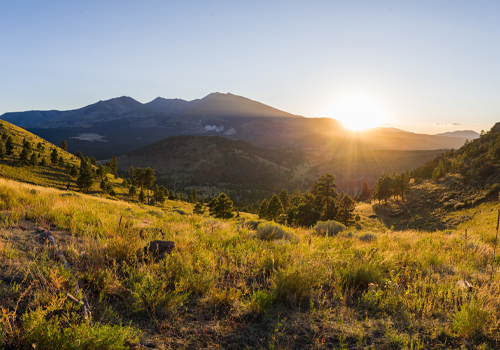
From the famous red rocks of Sedona to Ponderosa pine forests, from southwestern desert to alpine tundra, the Coconino National Forest is one of the most diverse and unforgettable destinations in the country.
One of the most diverse National Forests in the country with changing landscapes and activities around every corner. Explore mountains and canyons, fish in small lakes, and wade in lazy creeks and streams. Bring your camera and don't forget your swim suit, hiking shoes, and fishing pole...come and see!
Updates from the Coconino National Forest
-
Get News Via Email

Sign up for our news releases to stay in the know about the Coconino National Forest.
Plan Your Visit
-
Special Places
Scenic Drives, Ancient Cliff Dwellings, Petroglyphs - even an Apollo Training Site! Only on the Coconino!
-
Be Prepared

You'll want to lose yourself in the adventure, but maps and brochures will help you find your way.
-
Passes/Permits

Red Rock Pass, fuelwood permits, events, research - passes and permits for all your needs.
Discover More about the Coconino National Forest
-
Caring for the Land

Learn how the Coconino National Forest cares for the land including the Forest Plan, projects, the Four Forest Restoration Initiative, and the Fossil Creek Comprehensive River Management Plan (CRMP).
-
Partnering with Veterans

The Flagstaff Ranger District had the honor of working with the AZT VETS and the Arizona Trail Association to protect and maintain a stretch of the Arizona Trail. This inspirational video explains how Veterans find healing while helping the land.
Hot topics:
Road Status Four Forest Restoration Initiative
Verde River Conditions Prescribed Fires and Smoke FAQs
Highlighted Areas
Oak Creek Canyon Scenic Drive

Get your camera ready for this one, and don't forget your swimsuit, hiking shoes, and fishing pole. Just south of Flagstaff, Arizona State Route 89A descends a breathtaking series of switchbacks into a scenic, smaller cousin of the Grand Canyon. Known for colorful rocks and unique formations, Oak Creek Canyon is famous the world around for its spectacular scenery.
Before you drive into the canyon you'll want to stop at Oak Creek Canyon Vista. Here you can get a bird's eye view of what awaits you down the road and, at the same time, shop for Native American jewelry and other craft items from the local Native American artists who set up displays along the pathways.
Once you've snaked your way down the switchbacks, SR 89A winds a lazy course down the length of Oak Creek Canyon. It's actually possible to enjoy the scenery here without leaving your car, but most people choose to get to know these crimson cliffs and crystal pools on a more personal basis. For that purpose there are plenty of overlooks, picnic areas, swimming holes and hiking trails all along the drive. At Midgely Bridge, there's a vista point with an especially unforgettable backdrop where you'll want to stop and use that wide-angle lens.
As you leave Oak Creek Canyon and continue past Sedona through Red Rock Country, an observer with a sharp eye will recognize familiar shapes among the natural sculptures that form the horizon. Keep an eye out for Steam Boat Rock, Courthouse Butte, Bell Rock and more.
You can continue down this scenic route to Interstate 17 and then back to Flagstaff, or you may want to turn around and do it all over again. If you're driving a high clearance vehicle, another way to complete the loop is to return to I-17 via the unpaved, rocky Schnebly Hill Road rather than State Route 179. The vistas along this rocky but rewarding backroad are as good, if not better, than any along the rest of the drive. A high clearance vehicle is highly recommended for this route. In winter months, the upper part of Schnebly Hill Road is closed above Schnebly Hill Vista (near the top of the ascent up Bear Wallow Canyon), and the unpaved portion may be completely closed during wet weather conditions. Check Road Status before attempting this alternative route.
Attractions: Picnicking, waterplay, hiking, fishing, wildlife watching, photography
Road Condition: All roads (except alternative route up Schnebly Hill Road) are paved and plowed, but may be slippery after a winter storm.
Driving Time: 2.5 hours or all day.
Honanki Heritage Site
This site closes when the temperature is over 100 degrees Fahrenheit or when the roads are impassable.

 Honanki and its sister site, Palatki, were the largest cliff dwellings of the Red Rock country between AD 1150 - 1350. The Sinagua, ancestors of the Hopi, lived here preparing meals, raising their families, and making tools from stone, leather, and wood. Nearby they hunted for deer and rabbit, tended various crops, and gathered edible wild plants. They were first described by Dr. Jesse Walter Fewkes, famous turn-of-the century archaeologist from the Smithsonian Institution, who gave them the Hopi names of Honanki (Badger House) and Palatki (Red House). The Hopi, however, have no specific names for these sites.
The Honanki Heritage Site cliff dwelling and rock art site is located near the town of Sedona in north-central Arizona. The site is managed by the U.S. Forest Service under the Red Rock Pass Program. Please review the Archaeological Site Etiquette Guide before your visit.
The road to this site is generally passable to passenger cars when dry, but it is not regularly maintained by the County and has some rough and rocky stretches. High clearance vehicle recommended. The compensation for abusing your motor vehicle are wonderful views of the red rock formations that Sedona is so famous for.
Take a virtual tour of the Honanki and other heritage sites.
Palatki Heritage Site
This site closes when the temperature is over 100 degrees Fahrenheit or when the roads are impassable.
Ancient Cliff Dwelling and Pictographs Sheltered by Colorful Cliffs of Red Canyon
Reservations are required! Visit Recreation.gov.

Located northwest of Sedona, Arizona, the Palatki Heritage Site protects one of the largest cliff dwellings of the Red Rock Country between C.E. 1150-1350. The dwelling stands much as described and photographed by Dr. Jesse Walter Fewkes, in 1895 from the Smithsonian Institution, who gave them the name of Palatki, Hopi for Red House. In addition to the excellently preserved dwelling, there is “Rock Art”, Pictographs and Petroglyphs indicating that the area has been utilized by multiple cultures for thousands of years.
The Palatki Heritage Site cliff dwelling and rock art site is located near the town of Sedona in north-central Arizona. Currently managed by the U.S. Forest Service under the Red Rock Pass Program, the site is open to the general public for visits seven days a week (closed Thanksgiving and Christmas). A small visitor center and bookstore, run by the Arizona Natural History Association, is located a short distance from the parking lot.
To protect these sites, we have experienced guides who will assist you in understanding the people who lived here and their cultures. The tour includes a stop at the Cliff Dwellings and the Grotto “Rock art” site, lasting about 1¼ hour, with tours starting every half hour. The trail to the dwellings includes 60 uneven fairly strenuous steps; please be aware of personal limitations.
Due to the limited amount of space on site, the tours are limited to 12 visitors at a time. Dwelling and Grotto tours are offered every half-hour and last about 1½ hours. Reservations are required. Read our Archaeological Site Etiquette Guide.
The roads to Palatki are rough gravel roads. Passable for passenger cars but drivers need to go slowly and carefully.
Pets are not allowed beyond the parking area at this heritage site.
Crane Petroglyph Heritage Site
This site closes when the temperature is over 100 degrees Fahrenheit or when the roads are impassable.
A Rock Art Legacy from the Southern Sinagua of the Beaver Creek Community
 Formerly known as V Bar V Heritage Site, the Crane Petroglyph Heritage Site is the largest known petroglyph site in the Verde Valley, as well as one of the best-preserved. Acquired by the Coconino National Forest in 1994, the site is protected and kept open to the visiting public for their enjoyment and opportunity to learn more about our national cultural heritage. As partners in this effort, both the Verde Valley Archaeological Society and the Friends of the Forest provide interpretive tours and on-site management. The Red Rock Pass Program provides funding for the protection, enhanced amenities and facility maintenance under authority of the National Recreation Enhancement Act of 2005.
A visitor center and bookstore, operated by the Forest Service and the Arizona Natural History Association, is located about 100 yards from the parking area.
The Beaver Creek Rock Art Style: Rock art is one type of archaeological data that can be used to identify prehistoric cultures and time periods. Various styles of rock art have been identified, based on the kinds of elements, unique elements, relationships between elements, and manufacturing techniques. By making these observations, various rock art styles have been defined for the prehistoric Southwest. One of these styles -- the Beaver Creek Style -- has been identified through the studies of rock art sites in the Beaver Creek area, especially here at Crane Petroglyph Heritage Site. This research has resulted in the definition of the Beaver Creek Style, which is diagnostic of the Southern Sinagua between A.D. 1150 and 1400.
The documentation of the Crane Petroglyph Heritage Site has provided important information for defining important characteristics of the Beaver Creek Style.
Guided tours are provided by both the Verde Valley Archaeological Society and Friends of the Forest during these hours (petroglyph area is fenced and only accessible during regular visiting hours). Please read the Archaeological Site Etiquette Guide to help you better enjoy your visit without causing inadvertent damage to the site.
Take a virtual tour of Crane Petroglyph and other heritage sites.
Elden Pueblo Heritage Site
Elden Pueblo - Ancient Sinagua Village
Elden Pueblo is the site of an ancient Sinagua (Sin ah’ wa) village, inhabited from about A.D. 1070 to 1275. The site is unique for a variety of reasons. Most importantly, it makes archaeology and the study of ancient peoples accessible to the public. Since 1978, professional archaeologists have supervised members of the public in excavations, archaeological research techniques and artifact analysis through a variety of public and school programs.
Major Trading System
Conveniently located on U.S. Highway 89 north, Elden Pueblo is thought to have been part of a major trading system. This is evidenced by discoveries of trade items, such as macaw skeletons from as far south as Mexico, to shell jewelry from the California Coast. Important discoveries recently uncovered at Elden Pueblo suggest that the Sunset Crater volcano may have erupted over a much longer period of time than previously thought.
Elden Pueblo Trail Guide

The Arizona Natural History Association sponsors the Elden Pueblo Archaeology Project with the Coconino National Forest to provide opportunities for people to learn about and become involved in the science of archaeology.
Annual programs include several Public Archaeology Days, in which the public can participate in site tours, actual excavation, artifact washing and analysis, and try their hand at using ancient hunting weapons.
The August Public Day features a Primitive Technology Expo and the last Public Day of the year takes place in the fall as part of the annual Flagstaff Festival of Science.
Elden Pueblo School Programs

Elden Pueblo is available for school programs and groups of up to thirty people. Educational programs are correlated to the Arizona State Standards, grades 4-7 in Social Science and Science.
Custom programs are available, from 1-2 hours tours, to day-long excavations, or multiple-day programs.
Elden Pueblo hosts the Arizona Archaeology Society’s summer field school, where avocational archaeologists receive training in various archaeological skills, such as excavation, stabilization, mapping, and laboratory techniques.
There are also summer archaeology camps for students, from third grade and up.
Additional Information
Learn more about Elden Pueblo, including a history of the Sinagua, programs, a glossary, frequently asked questions, and a list of references.
Fossil Creek
Fossil Creek
There are ten recreation sites and trails along Fossil Creek Wild and Scenic River. Each site features deep pools and beautiful scenery.
Fossil Creek, one of two "Wild and Scenic" rivers in Arizona, seems to appear out of nowhere, gushing 20,000 gallons a minute out of a series of springs at the bottom of a 1,600 foot deep canyon. Over the years these calcium laden waters have laid down huge deposits of a type of limestone called travertine. Read more ...
Destinations: Flume Trail | Dixon Lewis Trail | Fossil Springs Wilderness | Other places to go
Open Fridays, Saturdays & Sundays in April through September
Spring-summer season.
Parking permit required.
No camping allowed.
Closed Mon-Thurs
Oct. 2 - March 31
Fall-winter season.
No permit required.
Some camping allowed.
Never allowed
Campfires and glass containers are never allowed in the area.
For current conditions, call Fossil Creek Hotline 928-226-4611
Cinder Lakes Apollo Training Area

Located in what is now known as the Cinder Hills OHV Area just northeast of Flagstaff are the remnants of the Cinder Lakes Crater Fields (Field #1 and Field #2) that were designed and constructed in July 1967 for astronaut training. Crater Field #1 was specifically designed to duplicate an area within the Mare Tranquillitatis in an effort to train astronauts for the future Apollo mission. Craters range in diameter from 5 to 40 feet and the first phase of the field, which consisted of 47 craters, occurred July 28-31, 1967. The field was expanded in October 8-12, 1967, which added 96 craters (or 143 total). The cinder field is made up of debris that erupted from Sunset Crater in approximately 1064 A.D.
The crater fields were suitable for testing rover prototypes and also used to test procedures for determining location within a cratered lunar landscape. Crews tested their ability to describe crater morphologies and stratigraphic relationships in unconsolidated materials as well as how to use hand tools and test deployment methods for prototype scientific experiment packages. In order to create the crater field, crews excavated holes and filled them with dynamite (312.5 lbs) and ammonium nitrate (13,492 lbs). Test explosions were used to calibrate the amount of explosive needed to generate craters of specific sizes.
Cinder Lake Crater Field #1 was produced in two stages and was 500 x 500 feet. Part of the first stage of the field creation was designed to simulate a small area of the Apollo 11 landing site that was observed in a Lunar Orbiter image. A simulated Lunar Module was installed on a ramp within the crater field for context of where the height of the Apollo ascent windows would be. Astronauts tested mobility systems such as the "Explorer" vehicle and an experimental vehicle called "Grover," which was used to training the Apollo prime and back-up crews.
Cinder Lake Crater Field #2 is located in an area that is used quite frequently by OHV enthusiasts, where basaltic cinders cover clay beds, and thus a light colored clay was excavated by the blasts and produced distinctive markings. Field #2 is 1,200 x 1,200 feet and contains 354 craters, which required 1,153 lbs of dynamite, 28,650 lbs of nitro-Carbo nitrate, and 40,000 ft of Primacord. Several sets of explosions were detonated to create the field and designed to overlap, which simulated lunar impact craters of intermediate age.
Even after all of this time, one can see where the detonations took place if they drive or hike through the area.
For even more photos and information, please visit the city's Flagstaff's Lunar Legacy website. As well, to view a video of how the craters were made, please visit USGS's Astrogeology Science Center website.
Follow this link to the images of this training.