Recreation

Lockett Meadow Access Closed to Motor Vehicles
Access to Lockett Meadow Campground is closed to motor vehicles due to Pipeline Fire Closure. Access now includes a 6 mile round trip hike. Other fall color opportunities can be found here.
Some tips to help you enjoy your recreation experience....
- Fireworks are never allowed on any National Forest.
- There are NO trash services on National Forests. Don't leave your trash.
- Check for FIRE RESTRICTIONS before thinking about starting a campfire.
- Human waste is a big problem on the Forest. Please see Leave No Trace - Dispose of Waste Properly for instructions on handling this "delicate" situation.
- The Digital Travel Map is a free resource for anyone headed out into the Coconino National Forest. Whether you're driving, hiking, riding, or exploring, you will find this full color, GPS-enabled map a handy reference to have on your mobile device. The map show trails, recreation sites, major landmarks, and forest boundaries in addition to the roads shown on the Motor Vehicle Use Map.
- When hunting, follow dispersed camping guidelines and the 14-day stay limit. See detailed hunting guidelines.
Thank you for helping us protect our natural resources for future generations!
Recreation Conditions Report
Area Name | Status | Area Conditions |
---|---|---|
A. B. Young Trail No. 100 | Open | |
Abineau-Bear Jaw Loop | Open | During the Winter, roads leading into the area are closed to vehicles. |
Airport Loop Trails | Open | |
Allens Bend Trail No. 111 | Open | |
Apache Maid Cabin | Open | Reservations are required and can be made through Recreation.gov or by calling (877) 444-6777. |
Apache Maid Trail No. 15 | Open | |
Arizona Nordic Village in the Winter | Open | |
Arizona Snowbowl Summer Skyride / Winter Ski Area | Open | |
Arizona Trail (Equestrian Bypass) No. 87C | Open | |
Arizona Trail (Marshall Lake-Fisher Point) No.87 | Open | |
Arizona Trail Passage 27: Blue Ridge | Open | |
Arizona Trail Passage 28: Happy Jack | Open | |
Arizona Trail Passage 34: San Francisco Peaks | Open | |
Around the Peaks Loop | Closed | Closed due to the Pipeline Fire Closure Order. |
Ashurst Lake | Open | During the winter, roads leading into the area are closed to vehicles. Road closures. |
Ashurst Lake Campgrounds | Open | |
Aspen Nature Loop Trail No. 73 | Open | |
Babe Haught Trail No. 43 | Open | |
Baldwin Trail | Open | |
Banjo Bill Picnic Site | Closed | Due to a wet-weather event rockfall, Banjo Bill Day Use/Picnic Area is closed. Local forest and engineering personnel are working on clearing the area. |
Barbershop Trail No. 91 | Open | |
Bear Mountain Trail No. 54 | Open | |
Bear Sign Trail No. 59 | Open | |
Beaver Creek Day Use Picnic Site | Open | |
Bell Rock Pathway / Vista | Open | |
Bell Trail No. 13 | Open | Do not attempt this trail in the summer without being prepared! Bring the necessary footwear, plenty of water and food. |
Big Park Trails | Open | |
Bismarck Lake Trail | Open | During the winter, roads leading into the area are closed to vehicles. Road closures. |
Blodgett Basin Trail No. 31 | Open | |
Blue Ridge Campground | Open | Season May to September |
Bob Bear (formerly Fossil Springs) Trail-No. 18 | Open | |
Bonito Campground | Open | |
Bootlegger Picnic Area | Open | |
Boynton Canyon Trail No. 47 | Open | |
Brins Mesa Trail No. 119 | Open | |
Broken Arrow Trail No. 125 | Open | |
Brookbank Trail No. 2 | Open | During the winter, roads leading into the area are closed to vehicles. Road closures. |
Bruce Brockett Trail | Open | |
Bull Pen Day Use Area & Trailhead | Open | DAY USE ONLY! Camping is never allowed here - day use only. |
Buttes and Boulders Loop | Open | |
C.C. Cragin (Blue Ridge) Reservoir | Open | Road access to the Resevoir is OPEN.. |
Cabin Loop Trail System | Open | |
Call of the Canyon Picnic Site | Open | Call of the Canyon (West Fork Trailhead) parking fills up every day by 9:30 a.m., seven days per week during busy seasons (summer, fall color, spring break). Have a backup plan for a different hike or day use area if the parking lot is full. |
Calloway Trail No. 33 | Open | |
Campbell Mesa Trail System | Open | Dogs must be on a leash at all times. Owners must pick up after their pets. DO NOT leave bags of poop from your pets along the trail/trailhead. If your pet defecates, you must bag the poop and take it with you--not leaving it for picking up later. If you do not want to do this, do not bring your pet on these trails. |
Canyon Vista Campground | Open | |
Carroll Canyon Area Trails | Open | |
Casner Canyon Trail No. 11 | Open | |
Casner Mountain Trail No. 8 | Closed | |
Cathedral Rock Trail No. 170 | Open | |
Cave Springs Campground | Open | Reservations must be made 3 days ahead of arrival. Reservations can be made by visiting Recreation.gov. |
Chavez Crossing Group Campground | Open | |
Childs Dispersed Camping Area | Unreachable | |
Cinder Hills Off Highway Vehicle Area | Open | |
Cinder Lakes Apollo Training Area | Open | |
Clear Creek Day Use Picnic Site | Open | |
Clear Creek and Clear Creek Group Campgrounds | Open | |
Clints Well Campground | Open | |
Cockscomb Trail System | Open | |
Cookstove Trail No. 143 | Open | |
Cornville Trail System | Open | |
Courthouse Butte Loop Trail | Open | |
Courthouse Vista | Open | |
Crescent Moon Cabin | Open | Reservations are required and can be made through Recreation.gov or by calling (877) 444-6777. |
Crescent Moon Picnic Site | Open | |
Crystal Point Trail | Open | |
Dairy Springs Campground | Open | |
Dairy Springs Trail No. 136 | Open | During the winter, roads leading into the area are closed to vehicles. Road closures. |
Deadmans Pass Trail | Open | |
Deer Hill Trail No. 99 | Closed | Closed due to the Pipeline Fire Closure Order. |
Deer Pass Trailhead | Open | |
Desert Canyon Loop Scenic Drive | Open | |
Devil's Bridge Trail No. 120 | Open | |
Doe Mountain Trail No. 60 | Open | |
Dogie Trail No. 116 | Open | Notes: Pets must be on-leash. Do not disturb cultural and archeology sites (Antiquities Act - 1906). No motorized vehicles on trail (Wilderness Act-1964). No motorized equipment or mechanized vehicles.(bicycles, strollers, etc.) in the Wild |
Donahue Trail No. 27 | Open | |
Doney Picnic Site | Open | |
Doney Trail No. 39 | Open | |
Dorsey Spring Trail No. 7 | Open | During the winter, roads leading into the area are closed to vehicles. Road closures. |
Double Springs Campground | Closed | |
Dry Creek Trail No. 52 | Open | The road to Dry Creek Trail is very primitive and suitable for high-clearance vehicles only. |
Elden Lookout Trail No. 4 | Open | |
Elden Pueblo Archaeological Site | Open | |
Elks Group Campground | Open | Season early May to September – reservable on Recreation.gov |
Encinoso Picnic Site | Open | |
Fatmans Loop Trail No. 25 | Open | Dogs must be on a leash at all times. Owners must pick up after their pets. DO NOT leave bags of poop from your pets along the trail/trailhead. If your pet defecates, you must bag the poop and take it with you--not leaving it for picking up later. If you do not want to do this, do not bring your pet on these trails. |
Fay Canyon Trail No. 53 | Open | |
Fernow Cabin | Open | Reservations are required and can be made through Recreation.gov or calling 1-877-444-6777. |
Flagstaff Ranger District | None | Some portions of this area are closed due to the Pipeline Fire Closure Order. |
Flume Trail No. 154 to Fossil Creek Dam | Unreachable | |
Forked Pine Campground | Open | Concessionaire leaves for the season in October. Campground remains open with limited amenities until the road closes in the winter. Refer to Ashurst Lake Campgrounds for current conditions. |
Fort Valley Trail System | Open | Some portions of this trail are closed due to the Pipeline Fire Closure Order. |
Fossil Creek | Temporarily Closed | |
Fossil Springs Wilderness | Temporarily Closed | |
Fred Haught Trail No. 141 | Open | |
General Crook Trail No. 130 | Open | |
Girdner Trail No. 162 | Open | |
Grasshopper Point Swimming & Picnic Area | Open | |
Griffith Spring Trail No. 189 | Open | During the winter, roads leading into the area are closed to vehicles. Road closures. |
H. T. Trail | Open | |
HS Canyon Trail No. 50 | Closed | |
Halfway Picnic Site | Open | |
Harding Springs Trail No. 51 | Open | |
Heart Trail No. 103 | Open | |
Hog Hill Trail No. 70 | Open | |
Honanki Heritage Site | Open | Closes when temperature is over 100 degrees Fahrenheit or when the roads are impassible. |
Horse Crossing Trail No. 20 | Open | |
Hot Loop Trail No. 40 | Open | |
Houston Brothers Trail No. 171 | Open | |
Huckaby Trail No. 161 | Open | |
Humphreys Trail No. 151 | Open | For current weather, visit National Weather Service. When there is snow on the San Francisco Peaks check the Kachina Peaks Avalanche Center Snowpack Summary for avalanche danger information. |
Inner Basin Trail No. 29 | Open | During the winter, roads leading into the area are closed to vehicles. Road closures. |
Jack's Canyon Camping and Climbing Area | Open | |
Jacks Canyon Trail No. 55 | Open | |
Jim Thompson Trail No. 124 | Open | |
Kachina Peaks Wilderness | Open | Some portions of this area are closed due to the Pipeline Fire Closure Order. |
Kachina Trail No. 150 | Open | |
Kehl Springs Campground | Open | |
Kelly Motorized Trail System | Open | During the winter, roads leading into the area are closed to vehicles. Road closures. |
Kelsey Trail No. 3 | Open | Roads leading into the area are closed to vehicles during the winter season. |
Kendrick Cabin | Open | Reservations are required and can be made through Recreation.gov or by calling (877) 444-6777. |
Kendrick Mountain Wilderness | Open | Most roads leading into the area are closed to vehicles during the winter season. View the Wilderness from Kendrick Park Watchable Wildlife Trail year-round. |
Kendrick Park Watchable Wildlife Trail | Open | |
Kinder Crossing Trail No. 19 | Open | |
Kinnikinick Lake | Open | During the winter, roads leading into the area are closed to vehicles. Road closures. |
Kinnikinick Lake Picnic Area | Open | During the winter, roads leading into the area are closed to vehicles. Road closures. |
Knoll Lake | Open | |
Knoll Lake Campground | Open | First come, first served. |
Lake Mary Narrows Boat Launch and Picnic Area | Open | Concessionaire is on-site and a fee is required May through September. Closing is at 7 p.m. Closed to Boat Trailer launching during low or frozen water. During the winter, vehicle access may be limited during snowy conditions. |
Lake Mary Recreation Corridor | Open | |
Lakeview Campground | Open | |
Lakeview Trail No. 132 | Open | During the winter, roads leading into the area are closed to vehicles. Road closures. |
Lava River Cave | Open | During the Winter, roads leading into the area are closed to vehicles. |
Ledges Trail No. 138 | Open | During the winter, roads leading into the area are closed to vehicles. Road closures. |
Lime Kiln Trail No. 82 | Open | |
Little Bear Trail No. 112 | Open | During the Winter, roads leading into the area are closed to vehicles. |
Little Elden Spring Horse Camp | Open | |
Little Elden Trail No. 69 | Open | During the winter, roads leading into the area are closed to vehicles. Road closures. |
Little Horse Trail No. 61 | Open | During the winter, roads leading into the area are closed to vehicles. Road closures. |
Little L.O. Trail No. 6 | Open | Roads leading into the area are closed to vehicles during the winter season. |
Little Round Mountain Trail | Open | |
Llama Trail | Open | |
Lockett Meadow Campground | Closed | Inaccessible by motorized vehicle due to the Pipeline Fire closure. |
Long Canyon Trail No. 122 | Open | |
Long Canyon Trail No. 63 | Open | |
Long Valley Work Center Group Campground | Open | Season early May to mid-October – reservable on Recreation.gov |
Lower Lake Mary | Open | Closing is at 6 p.m. during the operational season. During the winter, roads leading into the area are closed to vehicles. |
Lower Lake Mary Picnic Area | Open | Concessionaire is on-site and a fee is required May through October. |
Loy Canyon Trail No. 5 | Open | |
Mail Trail No. 84 | Open | |
Manzanita Campground | Open | |
Margs Draw Trail No. 163 | Open | |
Marshall Lake | Open | During the winter, roads leading into the area are closed to vehicles. Road closures. |
Maxwell Trail No. 37 | Open | |
Midgley Bridge Observation Site | Open | |
Mogollon Rim Ranger District | None | |
Mooney Trail No. 12 | Open | |
Moqui Group Campground | Open | Season early May to September – reservable on Recreation.gov |
Mormon Lake | Open | |
Mormon Mountain Trail No. 58 | Open | During the winter, roads leading into the area are closed to vehicles. Road closures. |
Munds Mountain Trail No. 77 | Open | |
Munds Mountain Wilderness | Open | |
Munds Wagon Trail No. 78 | Open | |
Myrtle Trail No. 30 | Open | |
Mystic Trail | Open | |
North Urban Trail System - East | Open | |
North Urban Trail System - West | Open | |
North Wilson Trail No. 123 | Open | |
O'Leary Group Campground | Open | |
O'Leary Peak Trail | Open | During the winter, parking area may be inaccessible to vehicles. |
Oak Creek | Open | |
Oak Creek Canyon | Open | |
Oak Creek Canyon Scenic Drive | Open | |
Oak Creek Visitor Center | Open | 8:00 a.m. to 4:30 p.m., seven days a week. |
Oak Creek Vista | Open | 9:00 a.m. until 4:00 p.m. Monday thru Friday, weather permitting. The Native Americans for Community Action concession/vendor area is open, but the Arizona Natural History Association and Forest Service seasonal information booth at the Vista is closed. |
Old Caves Crater Trail | Open | |
Oldham Trail No. 1 | Open | During the winter, roads leading into the area are closed to vehicles. Road closures. |
Painted Desert Vista/Doney Picnic Areas | Open | |
Palatki Heritage Site | Open | This site closes when the temperature is over 100 degrees Fahrenheit. |
Parsons Trail No. 144 | Open | Notes: Camping/campfires within the first 3 miles of the trail is prohibited (see Forest Order 04-02-07-R for more details) Pets must be on-leash. Do not disturb cultural/archeology sites (Antiquities Act 1906). No motorized vehicles in the wilderness." |
Peak View Winter Recreation and Parking Area | Open | |
Pine Canyon Trail No. 26 | Open | |
Pine Flat Campground | Open | |
Pine Grove Campground | Open | |
Pipeline Trail No. 42 | Open | |
Plateau Lakes Scenic Drive | Open | |
Priest Draw Trail and Bouldering Area | Open | During the winter, roads leading into the area are closed to vehicles. Road closures. |
Pumphouse Wash (FR 237) Dispersed Camping Area | Open | During the winter, roads leading into the area are closed to vehicles. Road closures. |
Purtyman Trail | Open | |
Red Mountain Trail No. 159 | Open | |
Red Rock Loop Trail | Open | |
Red Rock Ranger District | None | |
Red Rock Ranger District Visitor Center | Open | |
Red Rock-Secret Mountain Wilderness | Open | |
Red Rocks/Sycamore Canyon Loop Scenic Drive | Open | |
Rim Road/General Crook Trail Loop | Open | During the winter, roads leading into the area are closed to vehicles. Road closures. |
Rock Crossing Campground | Open | Season early May to September – reservable on Recreation.gov |
Rock Crossing Trail No. 18 | Open | |
Rocky Ridge Trail No. 153 | Open | |
Sandy Seep Trail No. 129 | Open | |
Sandys Canyon Trail No. 137 | Open | |
Schnebly Hill Trail No. 158 | Open | |
Schnebly Hill Vista Observation Site | Unreachable | High clearance vehicles are recommended to reach the observation site from I-17. DO NOT attempt to drive up or down Schnebly Hill without a high clearance 4-wheel drive vehicle. |
Schuerman Mountain Trail No. 56 | Open | On weekdays when school is in session, DO NOT park on high school property. Use dirt pullouts on east side of road. |
Schultz Creek Trail No. 152 | Open | Some portions of this trail are closed due to the Pipeline Fire Closure Order. |
Schultz Pass Road Scenic Drive | Closed | Closed due to the Pipeline Fire Closure Order. During the winter, roads leading into the area are closed to vehicles. |
Schultz Tank | Closed | Closed due to the Pipeline Fire Closure Order. During the winter, roads leading into the area are closed to vehicles. |
Secret Canyon Loop Trails | Closed | |
Secret Canyon Trail No. 121 | Closed | The road to Secret Canyon Trail is very primitive and suitable for high-clearance vehicles only. |
Secret Mountain Trail No. 109 | Open | |
Slate Mountain Trail No. 128 | Open | |
Slide Rock State Park | Open | This park is managed by Arizona State Parks and Trails. Check Slide Rock State Park on Arizona State Parks for details and status. |
Snowbowl Scenic Drive | Open | |
Soldier / Long Lakes | Open | |
Soldier Pass Trail No. 66 | Open | |
Soldier Trail No. 21 | Open | |
Stage Stop Day Use Area | Open | |
Sterling Pass Trail No. 46 | Open | |
Stoneman Lake | Open | |
Strawberry Crater Trail | Open | Access via FR546 damaged by flooding in summer 2022. High clearance recommended. |
Strawberry Crater Wilderness | Open | Access via FR546 damaged by flooding in summer 2022. High clearance recommended. |
Sunset Trail No. 23 | Open | During the winter, roads leading into the area are closed to vehicles. Road closures. |
Sycamore Canyon Wilderness | Open | Access via FR538 is closed to vehicles in the winter. |
Sycamore Canyon Wilderness Northeast Trail System | Open | During the winter, roads leading into the area are closed to vehicles. Road closures. |
Sycamore Canyon Wilderness Southeast Trails | Open | |
Taylor Cabin Trail No. 35 | Open | During the winter, roads leading into the area are closed to vehicles. Road closures. |
Telephone Trail No. 72 | Open | |
Templeton Trail | Open | |
Thomas Point Trail No. 142 | Open | |
Towel Creek Trail No. 67 | Open | |
Tramway Trail No. 32 | Open | |
Turkey Creek Trail No. 92 | Open | |
Turkey Springs Trail No. 217 | Open | |
U-Bar Trail No. 28 | Open | |
Upper Lake Mary | Open | Low Water - Launch at Your Own Risk - Large Watercraft Not Recommended |
Upper Lake Mary Boat Launch & Picnic Area | Open | Low Water - Launch at Your Own Risk - Large Watercraft Not Recommended |
V Bar V Heritage Site | Open | This site closes when the temperature is over 100 degrees Fahrenheit. |
Verde River | Open | |
Victorine Trail No. 101 | Open | |
Volcanoes And Ruins Loop Scenic Drive | Open | |
Vultee Arch Trail No. 22 | Open | The road to Vultee Arch Trail is very primitive and suitable for high-clearance vehicles only. |
Walker Basin Trail No. 82 | Open | |
Waterfall Trail on Fossil Creek | Unreachable | |
Waterline Trail | Closed | Closed due to the Pipeline Fire Closure Order. |
Weatherford Trail No. 102 | Closed | Partially closed due to the Pipeline Fire closure. |
West Clear Creek | Open | |
West Clear Creek Trail No. 17 | Open | |
West Clear Creek Wilderness | Open | |
West Clear Creek Wilderness - Mogollon Rim | Open | |
West Fork of Oak Creek No. 108 | Open | |
West Sedona Designated Dispersed Camping & Day-use | Open | These designated sites are the only areas you may camp in within the west Sedona area. Dispersed camping is prohibited outside of these sites. |
West Sedona OHV Routes | Open | |
Wet Beaver Creek | Open | |
Wet Beaver Wilderness | Open | |
White Bridge Picnic Site | Open | |
White Hills | Open | |
White Mesa Trail No. 86 | Open | |
Wier Trail No. 85 | Open | |
Willow Crossing Trail No. 38 | Open | |
Wilson Canyon Trail No. 49 | Open | |
Wilson Mountain Trail No. 10 | Open | |
Wing Mountain Dispersed Camping | Open | During the Winter, roads leading into the area are closed to vehicles. |
Winter Cabin Trail No. 70 | Open | During the winter, roads leading into the area are closed to vehicles. Road closures. |
Wood Memorial Trail | Open | During the winter, roads leading into the area are closed to vehicles. Road closures. |
Woods Canyon Trail No. 93 | Open | |
Yavapai Vista | Open |
Spotlights
Flagstaff Ranger District

The Flagstaff Ranger District encompasses nearly 850,000 acres of National Forest lands around the Flagstaff area, from Mormon Lake and Anderson Mesa to north of the San Francisco Peaks.
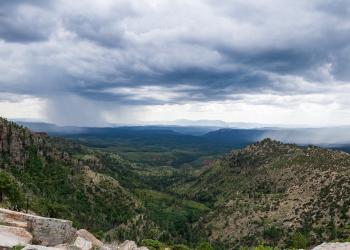
 At 12,633 feet, the San Francisco Peaks is not only the dominant feature of the forest area we call the Volcanic Highlands, it's also the highest mountain in Arizona. Three of the summits that ring this dormant volcano's now quiet inner caldera are higher than any other mountain in the state.
This mountain is sacred to the native peoples that live in the area and its soaring profile set against a blue Arizona sky serves as a source of awe to contemporary residents and visitors. Views from the summit of the San Francisco Peaks stretch to the Grand Canyon's North Rim over eighty miles away. Hiking, sightseeing, wildlife watching and skiing are the predominant recreation activities enjoyed in this land of mountains, forests and lava flows.
Flagstaff Ranger District, extends from north of the Peaks to the south. This rolling highland is a land of ponderosa pine forests and pinyon/juniper woodlands clustered around broad prairies and small lakes. Arizona's largest natural lake, Mormon Lake, is located here. The area is also known for its plentiful wildlife. Large herds of elk roam the forests and edgelands. Bald eagles and ospreys live and hunt around the lakes. Pronghorn antelope graze the prairies.
Principal recreation activities among the lakes and prairies are boating, fishing, camping, and wildlife watching. The area also boasts some excellent cross-country skiing in good snow years.
Recreation Activities for the Flagstaff District:
- Campgrounds
- Trails
- Wilderness Areas, Boating/Fishing Sites, Scenic Drives
- Picnic Areas, Archaeology Sites, Cabin Rentals and Winter Activities
More Information
Sedona Area OHV Routes

Eleven different OHV routes are highlighted within the Sedona area of the Red Rock Ranger District, ranging from Easy (dirt forest road) to Extreme Difficulty (4-wheel drive and high clearance necessary). Please keep in mind there is no operating a motor vehicle off an open and authorized road.
Oak Creek Canyon Scenic Drive

Get your camera ready for this one, and don't forget your swimsuit, hiking shoes, and fishing pole. Just south of Flagstaff, Arizona State Route 89A descends a breathtaking series of switchbacks into a scenic, smaller cousin of the Grand Canyon. Known for colorful rocks and unique formations, Oak Creek Canyon is famous the world around for its spectacular scenery.
Before you drive into the canyon you'll want to stop at Oak Creek Canyon Vista. Here you can get a bird's eye view of what awaits you down the road and, at the same time, shop for Native American jewelry and other craft items from the local Native American artists who set up displays along the pathways.
Once you've snaked your way down the switchbacks, SR 89A winds a lazy course down the length of Oak Creek Canyon. It's actually possible to enjoy the scenery here without leaving your car, but most people choose to get to know these crimson cliffs and crystal pools on a more personal basis. For that purpose there are plenty of overlooks, picnic areas, swimming holes and hiking trails all along the drive. At Midgely Bridge, there's a vista point with an especially unforgettable backdrop where you'll want to stop and use that wide-angle lens.
As you leave Oak Creek Canyon and continue past Sedona through Red Rock Country, an observer with a sharp eye will recognize familiar shapes among the natural sculptures that form the horizon. Keep an eye out for Steam Boat Rock, Courthouse Butte, Bell Rock and more.
You can continue down this scenic route to Interstate 17 and then back to Flagstaff, or you may want to turn around and do it all over again. If you're driving a high clearance vehicle, another way to complete the loop is to return to I-17 via the unpaved, rocky Schnebly Hill Road rather than State Route 179. The vistas along this rocky but rewarding backroad are as good, if not better, than any along the rest of the drive. A high clearance vehicle is highly recommended for this route. In winter months, the upper part of Schnebly Hill Road is closed above Schnebly Hill Vista (near the top of the ascent up Bear Wallow Canyon), and the unpaved portion may be completely closed during wet weather conditions. Check Road Status before attempting this alternative route.
Attractions: Picnicking, waterplay, hiking, fishing, wildlife watching, photography
Road Condition: All roads (except alternative route up Schnebly Hill Road) are paved and plowed, but may be slippery after a winter storm.
Driving Time: 2.5 hours or all day.
Red Rock Ranger District

The colorful collection of buttes, pinnacles, mesas, and canyons surrounding Sedona is famous the world around for its red rock vistas. Over the years, this area has served as the setting of many western novels and movies and has been the subject of uncounted paintings, photographs, and other works of art. The remains of ancient wetlands, these crimson cliffs have been carved by the forces of the desert into one of nature's most magnificent masterpieces.
No matter what you do in Red Rock Country, you're always sightseeing. Ways to get even closer to all this scenery includes: hiking, horseback riding, taking a scenic drive, sliding down a natural waterslide, picnicking, camping, taking lots of photos and fishing in Oak Creek. The Red Rock District includes some 550,000 acres of magnificent splendor. Some areas require a pass to park, so be sure to check out the information about our Red Rock Pass Program.
Get the scoop on the Red Rock Ranger District!
- Recreation Guide [PDF]
- Recreation Maps
- Red Rock Pass Information and find out where to get a Red Rock Pass
- Fee-Free Days
- Road Status
- Forest Orders
Recreation activities for the Red Rock Ranger District shown in tables:
- Campgrounds
- Trails (A-J)
- Trails (K-Z)
- Wilderness Areas, Boating/Fishing Sites, Scenic Drives
- Picnic Areas, Archaeology Sites, Cabin Rentals and Additional Information
Mogollon Rim Ranger District

The Mogollon Rim is a rugged escarpment that forms the southern limit of the Colorado Plateau.
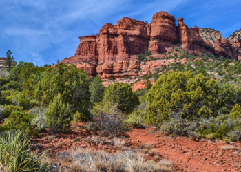
 It extends across the entire forest and provides excellent views within Plateau Country and Desert Canyon Country as well. Dropping as much as 2,000 feet in some areas, the Rim provides some of the most far-reaching scenery in Arizona. Views stretch from its rocky precipice to Four Peaks of the Mazatzals northeast of Phoenix.
Needless to say, sightseeing is a favorite activity along the Rim, but this forest area also boasts a historic system of hiking and horseback trails, a couple of picturesque lakes for boating and fishing, and backcountry skiing for wilderness adventurers. The Mogollon Rim is home to Camp Colley, an outdoor adventure camp at Little Moqui, run by the City of Phoenix, Parks and Recreation.
The photo above (see larger view) was taken by Mark Hickcox, Civil Engineer Tech on the Mogollon Rim District, from the Hutch Mountain Lookout Tower in the summer of 2011. It is looking south-east toward Long Lake.
Recreation activities for the Mogollon Rim District:
More information
Hunt Unit 11M (Peaks)
A primarily roadless and Wilderness hunt area designated to help restore aspen, in particular young aspen sprouts that are browsed upon by elk and deer. It’s ideal for those seeking a unique and challenging hunt on foot or horseback.
The Coconino National Forest and Arizona Game & Fish Department (AZGFD) teamed-up to create this new AZGFD sub-unit. The Peaks Hunt is Game Management Unit 11M and was first established in 2011. It has since become a popular hunt with above average success even though it is listed as a “Limited Opportunity” hunt area.
The unit includes the San Francisco Peaks and Hart Prairie – some of the most scenic areas on the forest and the highest elevation in Arizona. The 1996 Hochderffer Fire (pictured here) and 2010 Schultz Fire burn scars are also within the unit boundary.
West Sedona Designated Dispersed Camping & Day-use

These designated dispersed camping areas provide eight main areas for dispersed camping that accommodate up to an estimated 200 campsites in total.
This system will protect natural resources, keeps the landscape being dotted by the creation of dispersed campsites, and still provides many places for visitors to camp and enjoy the beauty of west Sedona.
Dispersed camping in these designated areas will remain free and are on a first-come, first-served basis that allow up to 14 days of camping. Dispersed camping in west Sedona outside of these eight designated sites is prohibited. For more information on how this area was designated, the public scoping process, and the Decision Memo, please visit the West Sedona Designated Dispersed Camping and Day-use Area project page.