
Flagstaff Ranger District

The Flagstaff Ranger District encompasses 849,249 acres of National Forest lands around the Flagstaff area, from Mormon Lake and Anderson Mesa to north of the San Francisco Peaks. At 12,633 feet, the San Francisco Peaks is not only the dominant feature of the forest area we call the Volcanic Highlands, but also the highest mountain in Arizona. Three of the summits that ring this dormant volcano's now quiet inner caldera are higher than any other mountain in the state.

This mountain is sacred to the native peoples that live in the area and its soaring profile set against a blue Arizona sky serves as a source of awe to contemporary residents and visitors. Views from the summit of the San Francisco Peaks stretch to the Grand Canyon's North Rim over eighty miles away. Hiking, sightseeing, wildlife watching and skiing are the predominant recreation activities enjoyed in this land of mountains, forests and lava flows.
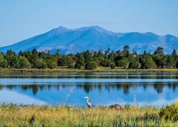
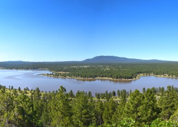
This rolling highland is a land of ponderosa pine forests and pinyon/juniper woodlands clustered around broad prairies and small lakes. Arizona's largest natural lake, Mormon Lake, is located here. The area is also known for its plentiful wildlife. Large herds of elk roam the forests and edgelands. Bald eagles and ospreys live and hunt around the lakes. Pronghorn antelope graze the prairies.

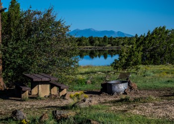
Principal recreation activities among the lakes and prairies are boating, fishing, camping, and wildlife watching. The area also boasts some excellent cross-country skiing in good snow years.

Complexes

The Ashurst Lake area makes a great launching point for all your water adventures. Ashurst Lake features a boat launch and two campgrounds, making it a prime spot for paddling, boat launches, overnight stays and wildlife viewing. Don't forget your towel!

A panoramic view of Ashurst Lake at Sunset.
Site Closed
The Ashurst Lake boat launch, located on the west side of the lake, is open as weather permits, and allows water access for fishing, paddling and other activities.
A campsite at Ashurst Lake Campground.
Site Closed
Ashurst Lake Campground (and its sister site, Forked Pine Campground) rests on the shores of Ashurst Lake, which has good opportunities for fishing and watersports.
A campsite at Forked Pine Campground.
Site Closed
Forked Pine Campground rests on the shores of Ashurst Lake, which has ample opportunities for fishing and watersports.

The water levels may vary, but the chances for an adventure are consistent. The Lake Mary area features a variety of boat launches, day-use areas and paved parking lots, all easily accessible via low-clearance vehicle.

A panoramic view of Upper Lake Mary.
Site Open

Upper Lake Mary is the largest of Flagstaff's twin lakes.

Panoramic image of Lower Lake Mary Picnic Site ramada.
Site Open

Sometimes it's a lake. Sometimes it's not.

Site Closed

There are a number of reasons to have a picnic at Lake Mary Narrows.

Panoramic view of Lakeview campground entrance sign.
Site Closed

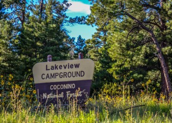
Lakeview Campground is located near Upper Lake Mary with easy walking access to the water via the Wood Memorial Trail (0.5 miles) or by car.

The Mount Elden/Dry Lake Hills (MEDL) trail system located just north of Flagstaff was dedicated in 1987, and features numerous trails that circumnavigate, climb and descend the steep flanks of Mount Elden and Dry Lake Hills.

The non-motorized MEDL area is composed of rugged volcanic mountains that are part of the San Francisco volcanic field. Trails in this area provide fantastic views of the San Francisco Peaks and surrounding Flagstaff.

The MEDL trails can be accessed at various trailheads; the most popular including the Schultz Creek Trailhead, Sunset Trailhead, Schultz Tank Trailhead, Oldham Trailhead and Elden Lookout Trailhead. There are eight trailheads total providing access to 25 designated National Forest System trails, including a segment of the Arizona National Scenic Trail, Flagstaff Loop Trail, and the historic Beale Wagon trail. 

USDA Forest Service Logo

Apollo Trail is part of the Mount Elden Dry Lake Hills Trail System and the Sch

A panoramic view of Flagstaff and monsoon as seen from Mt Elden Lookout Tower in the summer of 2013..

Elden Lookout Trail is part of the Mount Elden Dry Lake Hills Trail System.

A panoramic view of Flagstaff below Fatmans Loop Trail.

Fatmans Loop Trail (yes, it's spelled Fatmans without an apostrophe) is part of the Mount Elden Dry Lake Hills Trail System.

USDA Forest Service Logo

Little Elden Trail is part of the Mount Elden Dry Lake Hills Trail System and the Sc

USDA Forest Service Logo

Lower Oldham Trail is part of the Mount Elden Dry Lake Hills Trail System.

USDA Forest Service Logo

Rocky Ridge Trail is part of the Mount Elden Dry Lake Hills Trail System and provides a convenient connecting routes between

USDA Forest Service Logo

Sandy Seep Trail is part of the Mount Elden Dry Lake Hills Trail System.

USDA Forest Service Logo

Schultz Creek Trail is part of the Mount Elden/ Dry Lake Hills Trail System (MEDL), Schultz Tank Trail System, and the Schultz Creek Loops Trail System.

A panoramic view of the Sunset Trail and Mt Elden.

Views of the San Francisco Peaks, the volcanic fields east of Flagstaff, Sunset Crater and even the Painted Desert are yours to enjoy along this high country trail.

USDA Forest Service Logo

Named after its characteristics, the trail "swells" or winds its way up into the Dry Lake Hills and is part of the Mount Elden Dry Lake (MEDL) Hills Trail System.

USDA Forest Service Logo
Site Open

Upper Oldham Trail is part of the Mount Elden Dry Lake Hil

I comfortable series of trails atop Campbell Mesa that allows one to choose from hiking 2 miles to 5.7 miles on trails that interconnect with one another.

USDA Forest Service Logo

The Anasazi Loop Trail is one of five loops within the Campbell Mesa Loop Tr

USDA Forest Service Logo

The Campbell Mesa Loop Trail is one of five loops within the Campbell Mesa Loop Trails System.

USDA Forest Service Logo

The Continental Loop Trail is one of five loops within the Campbell Mesa Loop Tra

USDA Forest Service Logo

The Sinagua Loop Trail is one of five loops within the Campbell Mesa Loop Trails

USDA Forest Service Logo

The Walnut Meadows Loop Trail is one of five loops within the Campbell Mesa

The Kelly Motorized Trail System is located south of Flagstaff, between Mountainaire and Munds Park. It's a motorized off-roading dream, featuring more than 100 miles of both single track and wider trails. Area visitors can hike and overnight camp in the area as well.

Recreation Sites

Showing: 1 - 10 of 60 results

Afterglow Trail No. 421

Biking Hiking
Afterglow Trail is part of the Mount Elden Dry Lake Hills Trail System and the Schultz Creek Loops Trail System.The Schultz Creek area is the entry point to the Mt. Elden/Dry Lake Hills Trail System…

Airport Connector Trail No. 230A

Off-Highway Vehicles (OHV) Biking Hiking
The Airport Connector Trail is part of the Kelly Motorized Trail System.The Kelly Motorized Trail System is south of Flagstaff, Arizona, south of Lake Mary Road (opposite the Skunk Canyon, Fay…

Anasazi Loop Trail No. 310A

Biking Hiking Horse Riding and Camping Outdoor Science and Learning
The Anasazi Loop Trail is one of five loops within the Campbell Mesa Loop Trails System, and it shortcuts the west end of Campbell Mesa Loop Trail to make a 2.7-mile sub-loop out of Campbell Mesa…

Apollo Trail No. 426

Biking Hiking
Apollo Trail is part of the Mount Elden Dry Lake Hills Trail System and the Schultz Creek Loops Trail System.The Mount Elden/Dry Lake Hills (MEDL) trail system was dedicated in 1987. There are eight…

Arizona Nordic Village

Site Open
Winter Sports Hiking Biking
Arizona Nordic Village, located on Coconino National Forest land and operating under a special use permit, features a host of activities for every season.

Arizona Snowbowl

Site Open
Winter Sports Outdoor Science and Learning
Arizona Snowbowl, located on Coconino National Forest land and operating under a special-use permit, offers exciting runs down Arizona's highest mountain as a full-service downhill ski area.

Around the Peaks Loop

Site Open
Scenic Drives
This drive takes you all the way around Arizona's highest mountain, winding through a land of pine forests and aspen groves, open prairies and rustic homesteads. Anytime is a good time to enjoy this…

Ashurst Lake

Site Closed
Water Activities Hunting, Fishing and Shooting Outdoor Science and Learning
The Ashurst Lake boat launch, located on the west side of the lake, is open as weather permits, and allows water access for fishing, paddling and other activities.

Ashurst Lake Campground

Site Closed
Picnicking Outdoor Science and Learning Hiking Hunting, Fishing and Shooting Water Activities
Ashurst Lake Campground (and its sister site, Forked Pine Campground) rests on the shores of Ashurst Lake, which has good opportunities for fishing and watersports.

Bonito Campground

Site Closed
Picnicking Hiking Outdoor Science and Learning
Bonito Campground is named for the Bonito Lava Flow which oozed across this high desert plain some 900 years ago.

Last updated December 16, 2025