

Incident Information

An image of the homepage of Inciweb.
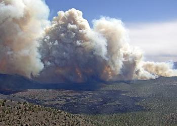
Any time there is a prescribed burn planned or wildfire that begins on the Coconino National Forest, we notify the public through many different mediums, including sending out news releases so that the newspapers and radio stations broadcast the information.
We also post specific information about the burn projects online. Local Ranger Stations can also offer answers to many questions you may have. Click on the links below to keep informed about why you see smoke in the air:
- Check our Prescribed Burn Projects Inciweb page
- Sign up to receive our news releases
- Follow us on Twitter: @CoconinoNF
- Follow us on Facebook: @CoconinoNF
- Arizona Department of Environmental Quality Daily Burn Approvals. Approved burn projects and their technical locations are posted daily to ADEQs site. The Coconino NF's approved burns will have a "Burn #" beginning with "COF" so you can identify if any have been approved for the day.
Wildfire Smoke & Air Quality Resources
Smoke from prescribed burns and catastrophic wildfires can differ greatly in the threat it poses to the public. Regardless, smoke can cause stress by limiting your daily outdoor activities, isolating you from friends and family, and disrupting your daily routines. The resources below are provided to help you prepapre and be informed about smoke impacts as well as provide information on how to protect yourself when impacted by smoke:
- EPA Wildfire Smoke and Health Fact Sheets
- ADEQ Air Quality Division Portable Particulate Monitor Readings
- AirNow Fire and Smoke Map
- National Fire Situational Awareness GIS Map
- Wildfire Smoke: A Guide for Public Health Officials
Frequently Asked Questions
As visitation increases on the Coconino National Forest, officials ask for continued cooperation in preventing wildfires. Residents and visitors are being extra vigilant for fire safety. Here are some tips on how to report a fire.
- Call 911.
- Provide your name and phone number in case we need to call you back.
- Provide your location as specifically as possible. Refer to Forest Road numbers, estimated mileage from main road intersections and/or geographic landmarks. If you're carrying a smartphone, find your latitude and longitude to report. Many apps have this feature, including the "compass" app on iPhone. Example: "I’m on Forest Road 171 about a mile south of the junction with Forest Road 245. Coordinates are 34.29191667, -110.8677056."
- Describe what you observe, and if any people and vehicles are in the area.
- Don’t put yourself at risk. You’ve done your civic duty by reporting the fire. Leave the firefighting to the professionals and move a safe distance away.
We have year-round fire restrictions in effect in several areas of the forest, and we implement forest-wide restrictions and closures whenever conditions may warrant. More information about fire restrictions is available on our Fire Restrictions page.
Be aware that not all campfires you see may be illegal. Read more about what each stage of Fire Restrictions entails for more information.
If you witness an illegal campfire or other restriction violation and want to report it, here are some tips for what to do and what happens after you call:
- Call the Coconino National Forest Dispatch Center at 928-527-3552 or Coconino County Sheriff's non-emergency number at 928-774-4523, extension 1.
- Provide your name and phone number in case they need to call you back to clarify location.
- Provide your location of the illegal campfire as specifically as possible. Refer to Forest Road numbers, estimated mileage from main road intersections and/or geographic landmarks. If you're carrying a smartphone, find your latitude and longitude to report. Many apps have this feature, including the "compass" app on iPhone. Example: "I’m on Forest Road 171 about a mile south of the junction with Forest Road 245. Coordinates are 34.29191667, -110.8677056."
- The dispatch center will then search for an available emergency responder from the Forest Service, Sheriff's Office, or Arizona Game & Fish. Calls and incidents are prioritized due to the large number of requests for many different types of emergencies. If they are unable to respond that evening, Forest Service personnel will follow-up the next morning to check the location you provided.
What are the different levels and what do they mean?

We use 5 different color-coded levels to help the public understand fire potential. The purpose of this is for visitors to understand the current conditions and help mitigate their actions to prevent human-caused wildfires.
Fire Danger Level: LOW
When the fire danger is "Low," it means that fuels do not ignite easily from small embers, but a more intense heat source, such as lightning, may start fires in duff or dry rotten wood. Fires in open, dry grasslands may burn easily a few hours after a rain, but most wood fires will spread slowly, creeping or smoldering. Control of fires is generally easy.
Fire Danger Level: MODERATE
When the fire danger is "Moderate," it means that fires can start from most accidental causes, but the number of fire starts is usually pretty low. If a fire does start in an open, dry grassland, it will burn and spread quickly on windy days. Most wood fires will spread slowly to moderately. Average fire intensity will be moderate except in heavy concentrations of fuel, which may burn hot. Fires are still not likely to become serious and are often easy to control.
Fire Danger Level: HIGH
When the fire danger is "High," fires can start easily from most causes, and small fuels (such as grasses and needles) will ignite readily. Unattended campfires and brush fires are likely to escape. Fires will spread easily, with some areas of high-intensity burning on slopes or concentrated fuels. Fires can become serious and difficult to control unless they are put out while they are still small.
Fire Danger Level: VERY HIGH
When the fire danger is "Very High," fires will start easily from most causes. The fires will spread rapidly and have a quick increase in intensity, right after ignition. Small fires can quickly become large fires and exhibit extreme fire intensity, such as long-distance spotting and fire whirls. These fires can be difficult to control and will often become much larger and longer-lasting fires.
Fire Danger Level: EXTREME
When the fire danger is "Extreme," fires of all types start quickly and burn intensely. All fires are potentially serious and can spread very quickly with intense burning. Small fires become big fires much faster than at the "Very High" level. Spot fires are probable, with long-distance spotting likely. These fires are very difficult to fight and may become very dangerous and often last for several days or weeks.
Recent Large Wildfires on the Coconino National Forest
Check out stats and more information about several notable wildfires that have occurred within the last decade or so.