
Recent Large Wildfires
These are some of the more notable wildfires the Coconino National Forest has seen during recent years.
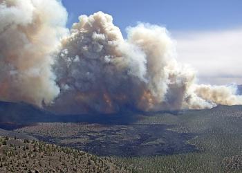
Pipeline and Haywire Fires (2022)
At a Glance:

- Reported: June 12, 2022 at 10:15 a.m.
- Location: 6 miles north of Flagstaff near Schultz Pass
- Cause: Human
- Size: Approximately 26,771 acres (Pipeline) and 5,575 (Haywire)
- Personnel: 919 (at the maximum) including helicopters, engines, water tender, dozers and hand crews.
- 100% Contained: July 29, 2022
The Pipeline Fire was reported June 12, 2022 at at 10:15 a.m. by a fire lookout when the fire was several acres in size. Resources on scene included two Hotshot crews, one dozer, one water tender, three patrol units, and six engines. Four air tankers and one Type 3 helicopter were ordered. Smoke was highly visible from Flagstaff, and the wind swept the smoke through Schultz Pass toward Doney Park. An Incident Management Team was ordered.
The next day, on June 13, strong winds continued to move the Pipeline Fire toward the northeast, as two additional wildfires--the Haywire Fire and Double Fire--were reported about 6 miles further ahead. Strong winds coupled with warm weather were the challenging factor for firefighters and air resources, as winds ranged from 40-50 mph for several days. The estimated size of the Pipeline was 5,000 acres.
The Type 2 California Incident Management Team 15 assumed management of the Pipeline and Haywire fires on June 14. The Haywire and Double Fire combined into one.
At this point, the Pipeline Fire was up to 20,178 acres and the Haywire Fire was estimated at 4,052 acres. Critical fire weather remained in effect due to dry conditions and high temperatures, lower wind speeds allowed for aerial operations throughout the day.
Evacuations were in place for Schultz Pass Road, Arizona Snowbowl, Crater Estates, O’Leary and east of Highway 89.
Peak fire activity happened June 16, 2022. There were 919 personnel on the scene, including 30 crews, 58 engines, 16 pieces of heavy equipment and 9 helicopters.
The Type 1 Great Basin Incident Management Team (IMT) 2 arrived at the Pipeline and Haywire fires on June 15. In addition to using water and retardant dropping aircraft, crews continued to look for opportunities to directly engage the fire with the intent to suppress the fire’s edge and to keep the fire from entering communities as it continued to move in a northeast direction. Crews continued to use the 2010 Schultz Fire and recent Tunnel Fire footprints to their advantage, as the fire raged through these burn scars. The Pipeline Fire was approximately 22,888 acres with 31% containment and the Haywire Fire was estimated at 5,065 acres with no containment.
By June 22, the Pipeline Fire was marked 70% contained and the Haywire Fire was 50% contained. An increase of monsoonal moisture occurred in the fire and increased cloud cover. Showers and thunderstorms produced flash flooding and debris flow off the Pipeline Fire scar, as well as the Tunnel and Museum fire scars.
The fires' final update occurred on June 25 and both fires were marked as 95% contained. Firefighters shifted focus to suppression repair to minimizing potential soil erosion and impacts resulting from fire suppression activities. These activities helped aid in mitigating impacts to incoming precipitation.
A Burned Area Emergency Response (BAER) team, led by Eric Schroder, completed their assessment and have recommended emergency stabilizations treatments to mitigate post-fire effects from the Pipeline Fire to National Forest System lands. BAER team assessments are rapid evaluations of post-fire conditions of the burned landscape to determine the level of risk from potential flooding and debris flow to values on National Forest System lands such as human life, safety, property, and critical natural and cultural resources. If unacceptable risks are found the team recommends appropriate and effective emergency stabilization measures to reduce the risks to National Forest lands and values. BAER emergency stabilization efforts are focused on the protection of human life, safety and property, as well as critical cultural and natural resource values on National Forest System lands.
The team identified the potential for post-fire flooding and debris flows in the same basins that had these events from the 2010 Schultz Fire, as well as the potential for flooding and debris flows in the Schultz Creek basin. The bulk of the proposed emergency stabilizations were related to protecting life and human safety on National Forest System lands and included a continued area closure for flood-prone areas of the Pipeline Fire at least through monsoon season. Additional proposed emergency stabilization measures included hazard signage on roads and trails, measures to protect major road and trail infrastructure within the fire area, a closure at the Bonito Amphitheater and O’Leary Trailhead, efforts to minimize the spread of invasive weeds and stabilization of cultural resource sites.
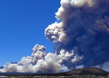
Tunnel Fire (2022)
At a Glance:
- Reported: April 17, 2022 at 4:22 p.m.
- Location: North of Flagstaff along Highway 89 (35°18'14.4"N 111°35'20.4"W)
- Cause: Unknown (Likely a holdover fire)
- Size: Approximately 19,060 acres
- Personnel: 430 (at the maximum) including helicopters, engines, water tender, dozers and hand crews.
- 100% Contained: June 11, 2022
The Tunnel Fire was reported April 17, 2022 and though the investigation never pinpointed an exact cause, it is widely believed to have originated from a holdover fire that was reignited by strong winds. On April 19, the fire had rapidly spread in a northeast direction due to high winds, going from 100 acres to 6,000 in one day. This prompted evacuations in the community of Doney Park and others. In total, 30 residences and 24 outbuildings were essentially lost in this fire. A closure of U.S. Highway 89 was initiated, and a Type 1 Incident Management Team was ordered on April 19. Due to back-to-back red flag warnings, the fire surged to more than 16,000 acres overnight and continued to grow.
By April 20, the fire grew to more than 19,000 acres. Forceful winds again limited the ability of air resources to support firefighting efforts, as strong up and downdrafts around the mountains kept aircraft from safely and effectively aiding in the firefight with retardant drops.
Residences, buildings, and watersheds that drain near them were the main emphasis for firefighters battling the Tunnel Fire. Overnight crews continued cooling hotspots in the Timberline Estates and Wupatki Trail subdivisions, as well as worked to contain multiple spot fires on the fire’s western flank near Forest Road 420 (Schultz Pass Road). These efforts were instrumental in keeping the fire from burning up steep slopes toward Schultz Peak and may help to minimize post-fire flood impacts.
On April 22, snow and rain helped douse dry grasses and kept them from igniting more easily, but precipitation levels weren’t high enough to affect large burning logs and extreme hotspots across most of the fire. High winds also resulted in drying out precipitation very quickly after it dropped. Containment increased from 0% to 3%.
Containment on the Tunnel Fire increased to 43% on April 28 due to firefighters’ continued hard work to mop- up and secure the fire’s perimeter in the Sunset Crater National Monument and Black Mountain areas. Suppression repair work occurred along Forest Road 545 and in Sunset Crater National Park. On April 29, the Tunnel Fire was transferred back to the Coconino National Forest from the Pacific Northwest Team 3.
A Burned Area Emergency Response (BAER) team, led by Brendan Waterman, began making burned area surveys of the Tunnel Fire April 30. BAER team assessments are rapid evaluations of post-fire conditions of the burned landscape to determine the level of risk from potential flooding and debris flow to values on National Forest System lands such as human life, safety, property, and critical natural and cultural resources. If unacceptable risks are found the team recommends appropriate and effective emergency stabilization measures to reduce the risks to National Forest lands and values.
BAER teams conduct field surveys and use science-based models to rapidly evaluate and assess the burned area. BAER is an emergency program for stabilization work that involves time-critical activities to be completed before the first damaging storm event to meet program objectives.
Backbone Fire (2021)
At a Glance:
- Started: Wednesday, June 16, 2021
- Location: Ten miles southwest of Pine, Ariz.
- Cause: Lightning
- Size: Approximately 40,855 acres
- Personnel: 707 (at the maximum) including helicopters, engines, water tenders, dozers and hand crews
- 100% Contained: July 22, 2021
The Backbone Fire was reported June 16, 2021 and was caused by lightning. The fire burned 10 miles southwest of Pine, AZ near the old Child's power plant, on the northern edge of the Matalzal Wilderness. Red Rock Ranger District forces conducted the initial attach on the fire, but the fire quickly grew to around 200 acres despite this prompt attack. Because of the fire's continued growth, difficult terrain, current and potential threat to life and property, the analysis indicated the fire should be managed at the Type 1 level. On June 17th a Type 1 Incident Management Team was ordered.
As the IMT was being briefed, the fire was estimated at 7,000 acres. It would double in size during the next six hours to over 17,000 acres. A full suppression strategy was implemented by the IMT, utilizing a variety of suppression tactics. Fuels throughout the fire were primarily grass/shrub, with timber above the Mogollon Rim. Elevations ranged between 2,568 and 7,210 feet. Due to prolonged drought, live and dead fuels were stressed and receptive to ignition and rapid rates of spread. Temperature during the initial attack phase reached 100 to 110 degrees with humidity in the single digits. On June 23rd and 24th, most of the areas of the fire received varying amounts of rain. With the precipitation and higher humidity, fire behavior moderated to only smoldering within the heavy fuels.
On July 1st at 0600 hours, management of the Backbone Fire was transferred to the local Forest Type 4 organization. At transfer of command, the fire had burned 40,855 acres and was 96% contained.
Employees on the Coconino National Forest worked diligently on Backbone Fire recovery, especially in and around Fossil Creek. Two wild and scenic rivers were heavily impacted, as were highly valued cultural assets. At the time of the in-briefing, the communities of Pine and Strawberry were in the process of being evacuated. Communities at risk were the towns of Pine, Strawberry and Camp Verde. Ranches and private inholdings were also at risk, in addition to recreation site infrastructure along Fossil Creek and at Child's Dispersed Camping Area.
The area is showing promising signs of natural regrowth and is responding positively to the already implemented treatments. Our Burned Area Emergency Response (BAER) engineers evaluated the Fossil Creek Road for potential threats to the road from flash flooding, debris flows impacting drainage crossings and its overall infrastructure due to increased erosion, sedimentation, and flows. Roads and trails are BAER critical values that need to be assessed for threats. BAER teams proposed emergency stabilization treatments and actions to minimize those threats.
Much of the burn area was estimated to have a lower level of debris-flow hazard in response to relatively common rainstorms. However, several smaller, steep, more severely burned watersheds in the central portion of the burn area as well as large parts of the Boulder Creek and Sally May watersheds were predicted to have moderate to high debris-flow hazard even from relatively common rainstorms. While predicted debris flow volumes are expected to be relatively small throughout most of the burn area for common events, a larger, higher-intensity rainstorm could trigger larger and more damaging debris flows.
Museum Fire (2019)
At a Glance:

- Started: July 21, 2019
- Location: One mile north of Flagstaff, Ariz., in the Dry Lake Hills area northwest of Mount Elden
- Cause: Human: spark from skidder during contracted restoration work
- Size: 1,961 acres
- Personnel: At the peak, 685 personnel
- 100% Contained: Aug. 15, 2019
The human-caused Museum Fire started at about 11:30 a.m. July 21, 2019, about one mile north of Flagstaff, Ariz. in the Dry Lake Hills area northwest of Mount Elden. The fire was caused in a steep-slope environment, when an excavator working on contracted restoration work likely struck a rock during operations. The resulting spark created a heat source that hibernated until ideal warm, dry and windy conditions allowed the heat source to grow into a small fire that was then spread by the wind. The Museum Fire investigation revealed that the fire was not caused by negligence, and that all proper inspections of equipment had been conducted. The excavator operator had completed a one-hour fire watch before leaving the area, and the last piece of equipment was used 14 hours prior to the first report of fire. The total estimated cost of suppression was an estimated $9 million as of Sept. 11, 2019.
Deep layers of forest fuels and roots can hold heat for extended periods. Although this is a rare occurrence, these fuels can burn and smolder underground for months without any sign of a fire, only to surface and ignite once conditions permit.
Within one hour of the first report of fire, the Coconino National Forest directed all available resources to the incident. A Type 1 Incident management Team was ordered within four hours of the report, and arrived the next day.
The Museum Fire burned 1,961 acres. A post-fire analysis shows that 50 percent of the wildfire burned at low severity, 38 percent burned at moderate severity and 12 percent of the area burned at high severity. The contractor was working on the Flagstaff Watershed Protection Project (FWPP), which is a collaborative fuels reduction project that aims to to help reduce the risk of devastating wildfire and post-fire flooding in the Rio de Flag and Lake Mary watershed. Coincidentally, some of the restoration work that had already been completed in the wildfire area did help to contain parts of the fire. The project was in its second phase of work with the Museum Fire occurred.
Tinder Fire (2018)
At a Glance:

- Started: Friday, April 27, 2018
- Location: East Clear Creek, 1.5 miles east of C.C. Cragin Reservoir
- Cause: Human: illegal campfire
- Size: 16,309 acres
- Personnel: At the peak, 695 personnel, 15 crews, 7 helicopters, 46 engines, 7 dozers, 16 water tenders.
- 100% Contained: May 24, 2018
On the heels of a dry winter, the 2018 fire season arrived early for northern Arizona. The previous winter had seen approximately one third the normal precipitation levels in the Mogollon Rim area. April was particularly dry and windy, with unseasonably warm daytime temperatures. Four Red Flag Warnings had been issued by the National Weather Service for the area since April 1. Daytime highs were often five to ten degrees above normal. The area where the Tinder Fire started had seen 25% of normal precipitation for the month. Stage I fire restrictions had been implemented April 23 in response to the dangerously dry conditions, strong winds, and forecast warm weather. In the days leading up to the Tinder Fire, temperatures were 10 to 15 degrees above normal.
The Tinder Fire was spotted at 11:43 a.m. on Friday, April 27, 2018, burning approximately 1.5 miles east of C.C. Cragin Reservoir (aka Blue Ridge Reservoir) on the Mogollon Rim Ranger District. The wildfire was human-caused, sparked by an illegal abandoned campfire during fire restrictions. The wildfire was burning in an area of standing pine and mixed conifer forest going into the bottom of East Clear Creek. Due to the complexity of the fire, challenging terrain, risks to nearby residential communities, severely dry conditions, windy weather, and other factors, a Type 1 Incident Management Team (IMT) was called in. On April 28, the Type 1 Southwest Area IMT arrived and took command of operations.
Red Flag Warning, Wind-driven Wildfire Growth, and Evacuations
High winds were forecast for Sunday, April 29, and a Red Flag Warning was issued by the National Weather Service. Overnight, the wildfire had spotted across to the east side of the East Clear Creek drainage, and Hotshot crews were sent to secure the three growing fires that had been established.
By 10 a.m., winds were gusting around 40 miles per hour, and the Coconino County Sheriff's Office started ordering evacuations of the southernmost subdivisions in the path of the wildfire. The southwest wind was aligned with East Clear Creek drainage, pushing the fire quickly up the canyon. By 1:30 p.m., all the Blue Ridge area subdivisions were under evacuation orders. The Coconino National Forest issued a Forest Order closing the area around the wildfire, Arizona Department of Transportation (ADOT) closed state Route 87 to the north, and the Federal Aviation Administration (FAA) implemented a Temporary Flight Restriction (TFR) over the area. The wildfire grew rapidly from around 500 acres in the morning to approximately 8,000 acres by the end of the day. High winds grounded air tankers until early evening and drove the fire into four communities. In the end, 33 primary residences were lost, as well as 54 outbuildings and other minor structures in the Blue Ridge communities south and east of state Route 87.
Drone Intrusion
Air operations were shut down for 15 minutes the morning of April 29 due to an illegal incursion of an Unmanned Aircraft System (UAS), commonly called a "drone," at the northern end of the wildfire around 10:15 a.m. The FAA had implemented a TFR restricting all air travel, including UAS, in the airspace above and around the wildfire. TFRs over wildfires protect emergency crews and aircraft actively engaged in fire suppression efforts. Air operations are required to shut down when any unauthorized incursion occurs, grounding firefighting aircraft. Delays due to incursions by UAS and other aircraft can lead to loss of property and lives. Luckily, there were no serious impacts from this incursion, but precious time was lost on what would become the worst day of this wildfire.
Wildfires and drones don't mix. Flying a drone over a wildfire without authorization, regardless of whether or not the FAA has issued a TFR, is illegal. Violations may result in serious civil and criminal penalties, including hefty fines and jail time. Learn more about Drones and Wildfire from the National Interagency Fire Center (NIFC). Visit the FAA's Know Before You Fly to learn more about the requirements and laws governing UAS flights.
Securing Property and Returning Residents to Communities
Over the following days, crews continued to work to suppress and contain the wildfire, and patrol and protect communities and structures. In communities directly impacted by the wildfire, crews sought out and extinguished remaining hot spots, mopped up the perimeter, and repaired damage caused by suppression activities. Arizona Power Service (APS) worked to replace damaged poles and restore compromised power lines so power could be restored. Five utility contractors tested propane systems and replaced damaged propane tanks. Once the communities were deemed safe, the Coconino County Sheriff's Office lifted the evacuation order, allowing residents to return to their properties Friday, May 4.
Winding Down in Windy Weather
The first few days of May brought increased humidity and precipitation. Snow and rain on May 2 helped limit fire activity. Crews quickly made progress towards containment on the wildfire, which had grown to over 12,000 acres. As warmer, drier weather moved in, fire personnel continued working to fully suppress the wildfire where they could do so safely and effectively. Crews performed burn-out operations, repaired damage caused by suppression efforts, mopped up, improved firelines, and patrolled the area. The Type 1 Southwest Area IMT transferred control of operations to a Coconino National Forest Type 3 team on May 7. By this time, the wildfire had grown to 16,309 acres and was 79% contained.
In expectation of windy conditions, Coconino National Forest and Arizona State Forestry crews worked to secure the northwest section of the wildfire May 9. The steep and rocky terrain of East Clear Creek canyon makes ground suppression efforts hazardous. Three helicopters with buckets were deployed to douse the area with water pulled from C.C. Cragin Reservoir. In advance of the strong and gusty winds forecast for the next two days, ground crews were staged to suppress portions of the wildfire trying to leave protection lines. The air and ground efforts were successful, resulting in no additional growth of the wildfire. Operations were scaled back to a Type 4 structure on May 12.
Slide Fire (2014)
At a Glance:

- Started: Tuesday, May 20, 2014
- Location: Oak Creek Canyon, just north of Slide Rock State Park (north of Sedona)
- Cause: Human
- Size: 21,227 acres
- Personnel: At the peak, 1,360 personnel, 13 Type I crews, 15 Type II crews, 9 helicopters, 63 fire engines, 5 dozers, 19 water tenders.
- 100% Contained: June 4, 2014
The Slide Fire began about 4 p.m. on May 20, 2014 just north of Slide Rock State Park in Oak Creek Canyon, Sedona and was human caused. Due to the size and complexity of the fire, a Type I Incident Management Team (IMT) was called in and took over management of the fire at 9 p.m. on May 21. Mandatory evacuations were immediately issued for all businesses and residents north of Slide Rock State Park for an approximate two-mile stretch and eventually up to the Switchbacks.
As the fire progressed up Oak Creek Canyon towards the Switchbacks and Pumphouse Wash Canyon, a pre-evacuation notice was issued to the residents of Kachina Village and Forest Highlands the afternoon of May 21. The fire was kept west of highway 89A and several fuel treatment projects were noted as having a significant impact in aiding the firefight and keeping it west of highway 89A and south of Forest Road 535 (just north of the Switchbacks). Specifically, those treatments were the Kachina Village Forest Health Project, Sinks Project, and Woody Ridge Forest Restoration Project. Click here to view the Slide Fire Fuels Treatment Effectiveness Report compiled in May 2014. The Type I IMT also posted several videos of flyovers [YouTube] over Oak Creek Canyon.
The Forest issued a Closure Order for the area on May 25 and no injuries or structures were lost during the fire. Residents and business owners who had to evacuate were allowed to return to their properties on May 29 at 1 p.m. Costs of fighting the fire exceeded $8.6 million and a Type III IMT took over management of the fire on May 31.
Post-fire effects quickly became the focus and what that would mean for visitors, business owners and residents in the area during monsoon. Significant flooding is possible through the canyon, as several areas burned intensely and will likely result in debris flowing through the canyon. Many recreation sites, trails and campground will remain closed until rehabilitation work is finished and safety can be established in those areas.
Schultz Fire (2010)
At a Glance:
- Started: Sunday, June 20, 2010
- Location: Eastern slopes of the San Francisco Peaks west of Highway 89, northeast of Flagstaff, Ariz.
- Cause: Human: abandoned campfire
- Size: Approximately 15,000 acres
- Personnel: Nearly 1,000 (at the peak) including air tankers, helicopters, engines, water tenders and hand crews.
- 100% Contained: July 9, 2010
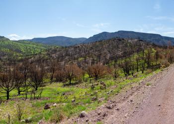
Employees on the Coconino National Forest worked diligently on Schultz Fire recovery. Since 2010, efforts throughout the 15,000 acre burn area have included an extensive list of on-the-ground projects as well as countless hours of work not as visible to the public eye such as environmental surveys and analyses, and creation and oversight of contracts and special use permits. Recovery efforts were underway before the fire was fully contained, and since then the Coconino National Forest has worked with multiple partners and volunteers to accomplish a remarkable amount of work.
In addition to contract work, the Flagstaff Ranger District hosted several volunteer replanting events. Volunteers helped plant approximately thousands of seedlings in the burn area off Schultz Pass Road. The area is showing promising signs of natural regrowth and is responding positively to the already implemented treatments. See the Schultz Fire Recovery and Restoration Accomplishments dropdown menu below this one to see more information.
The popular non-motorized trail Waterline Road (aka Waterline Trail) re-opened in 2013. The trail had been closed since the 2010 Schultz Fire due to the safety risks of falling trees and debris. Countless trees were falling into the road on a daily basis. Fire and recreation crews have worked over 3,600 hours to remove most of the imminent hazards.
The area around Little Bear Trail on the steep slopes of the Dry Lake Hills was devastated by the Schultz Fire. Subsequent washout damage caused by heavy monsoon rains kept the trail closed through the years since the fire. Volunteer organizations helped rebuild and reroute the trail, which was reopened in 2016.
Deer Hill Trail, a popular equestrian trail on the eastern flank of the San Francisco Peaks, was also closed due to safety risks caused by falling trees, erosion, and trail damage caused by the fire and heavy monsoon rains. The trail was reopened in 2017 following efforts to repair the trail, clear fallen trees, and mitigate hazards by Coconino National Forest staff and volunteer organizations.
The Coconino ordered a Burned Area Emergency Response (BAER) team to assess the impacts of the fire and the aftermath and determine appropriate mitigation measures.
Burned Area Emergency Response is “first aid” – immediate stabilization that often begins before a fire is fully contained. The BAER program doesn't seek to replace what is damaged by fire, but to protect life, property, water quality, and deteriorated ecosystems from further damage after the fire is out. Read more on the BAER program page.
Implementation crews worked around the clock and through holidays to complete emergency rehab work before the onset of monsoons.
Treatments in the first round of BAER were mostly complete before the first major flood on July 20, 2010. Following the monsoons and flooding, the forest implemented four additional rounds of BAER treatments. Treatments were designed for a 10-year storm event – the largest event for which success was likely, and therefore the largest for which the forest could receive funding. BAER efforts included:
- Over 3,000 acres of aerial mulching using certified weed free straw and later, woodshreds – Many areas were treated multiple times between the first phase prior to 2010 flooding and the winter snows of 2011. Nearly 2,000 tons of wood mulch was used on approximately 331 of those 3,000 acres. The mulch was created onsite using nearly 100 acres of hazard trees that were removed from within the burn area. The heavier weight of the woodsheds helped them stay on steeper slopes through wind and precipitation.
- Certified weed-free seeds applied aerially on 5600 acres – Seeds were a mixture of native species and sterile barley called “quickguard" used to rapidly establish ground cover.
- Approximately 660 acres of mulch and 1146 acres of certified weed free seed were applied within the Kachina Peaks Wilderness Area on extremely steep slopes and high severity burn.
- Armoring 8 drainage crossings and removing berms on Waterline Road to improve drainage
- Removing approximately 30 culverts along Forest Road 420 (Schultz Pass Road)
- Waterbar work on approximately 23 miles of roads to minimize concentration/acceleration of flow
- Log jam removal in several drainages to remove potential hazards for damming and breach flows created during flooding
- Drainage canals – including Copeland Canal from the FS/County boundary to Cinder Lake – sediment basins, scarification on east side of Hwy 89 to divert water/sediment away from homes
- Diversion and sediment basin construction and maintenance to divert water and trap sediment in safe locations in highly permeable soils to minimize protect homes in Doney Park from floodwater and sediment damage and divert water away from Highway 89 and the city landfill.
- Construction of 10 berms, 5 miles in length to protect homes, city landfill, and other infrastructure
- Construction of 89 acres of scarification zones to aid soils in absorbing flood water
- Installation of gates and safety/closure barriers
Storm patrols, and installation of warning signs, gates and closure barriers – Though closure enforcements were not specific to BAER, they were an important part of the emergency response effort.
Many FS employees also offered their time to assist with flood recovery efforts on the private lands such as sandbagging and debris removal.
The Coconino NF participated in the Ridgeline to Rio Summit, which included a group of experts from multiple State and Federal agencies, Universities and the private sector from around the country. These experts brought a wide range of expertise in hydrology, engineering and recovery efforts on large wildfires. Over the course of a week, the group examined potential comprehensive solutions to the flooding problems.
Long-term restoration
The start of long-term restoration efforts overlapped with the later phases of BAER activities. In 2012 the forest completed several new and continuing long term restoration projects. Additional efforts and maintenance will be ongoing for the next several years. Long term restoration projects include:
- Reconstructing Lockett Meadow Road– The Flagstaff Ranger District was able to reopen the road to public use in the fall 2012.
- Repairs and realignment of Forest Road 776 – Temporary repairs were made to support emergency access to the Cinder Hills area. In the spring of 2012, crews were able to fully realign and resurface the road removing it from the path of any future floodwaters and creating safer conditions for travelers.
- Restoration of recreation sites– Specialists installed warning and interpretive signs throughout the burn area, removed hazard trees from trails, and restored the amphitheater at Bonito Campground. In addition, several volunteer events were held this year to reconstruct the Weatherford, Little Elden, and Little Bear trails. Over 200 volunteers restored approximately 4.5 miles of trail in the summer of 2012. All three trails have been reopened to public use.
- Noxious weed treatments
- Monitoring seeded native plants and natural regrowth (such as the abundant aspen seedlings throughout the area)
- Wildlife habitat restoration
- Range allotment fence reconstruction
- Interpretation, awareness efforts, education and support for research efforts – The Coconino National Forest has hosted countless tours through the burn area every year. Tours have been given to partners, elected officials, media reporters, residents – including those personally affected by the fire and flood, as well as students of all ages for scientific research and education about fire on southwestern landscapes.
- Aspen regrowth protection– Jackstrawing is a restoration and resource protection method that involves felling multiple trees – usually conifers – within a stand of young aspen. Letting the trees fall in loose, criss-cross patterns on top of each other creates a collection of obstacles, several feet high, around aspen seedlings. Jackstrawing deters browsing animals such as elk from eating the aspen seedlings, giving them a chance to grow and strengthen until they can survive browsing affects. A total of 126acres have been treated with jackstrawing efforts so far. In the coming years, specialists anticipate applying this treatment to another 136 acres in the Schultz Burn Area.
- Seeding production and replanting– Soon after the Schultz Fire, silviculturists collected native seeds and sent them to the Navajo Forestry Greenhouse in Ft Defiance, and Northern Arizona University and Ponderosa School greenhouses in Flagstaff. In late 2011 and the spring and fall of 2012, thousands of year-old conifer seedlings were planted in the burn area. The Flagstaff Ranger District organized multiple volunteer events – attracting several hundred public participants of all ages from across the state. So far, approximately 1,000acres – 100,000 seedlings – have been replanted in the Schultz burn area either by volunteers or contractors. Volunteers planted over 100acres during spring and fall volunteer events in 2012. More events will be planned in 2013 for volunteers to plant approximately 100 acres. In 2013 a total of 2,000 additional acres are slated to be replanted. Stay tuned to the volunteer page for opportunities to get involved.
- Schultz Sediment Reduction Project–In March 2012 the Coconino NF began the analysis process for this project in response to a proposal submitted Coconino County to channel water runoff through private lands. The project team completed the entire analysis in only four months; All comments received were supportive, and the forest was ready for implementation by July. From there, the FS worked with Coconino County to establish details of the special use permit to be issued to the County for construction. Work on the National Forest cannot begin until Coconino County begins the same efforts on the private lands. Drainages constructed above the neighborhood will be deemed useless – and could even cause more damage – if connective infrastructure down flow isn’t also in place to safely divert floodwaters and sediment through the private lands.
- In 2012 successfully collaborated with the City of Flagstaff on the Waterline Road and Pipeline Reconstruction Project– The partnership resulted in the quick and efficient repair of the pipeline and the road, while minimizing damage to natural resources and impact to the Kachina Peaks Wilderness. Though it has been reconstructed, Waterline Road remains closed to public use due to numerous hazards. The countless trees and debris that have been falling across the road continue to pose a significant threat to public safety. Forest managers will reevaluate conditions in the spring of 2013.
In addition to ongoing work in the Schultz Burn area, the Coconino also continues efforts to reduce fire danger across the forest with various other forest health and fuels reduction projects including a partnership with the City of Flagstaff on the Flagstaff Watershed Protection Project.