

Collaborative Aquatic Landscape Restoration
The Forest Service manages more than 400,000 miles of streams and around 3 million acres of lakes across 193 million acres of national forests and grasslands. These waters are vital sources of clean drinking water for millions of Americans. The streams, rivers, ponds and lakes also support vital habitat for native fish and other aquatic organisms, including habitat for more than 140 threatened and endangered aquatic and amphibian species.
The Infrastructure Investments and Jobs Act established the Collaborative Aquatic Landscape Restoration Program, a remarkable opportunity to fund essential projects and to complete high priority projects on federal and non-federal land to improve water quality or restore passage for fish and other aquatic organisms.
The Forest Service announced a second round of Collaborative Aquatic Landscape Restoration funding of $28.1 million for eleven additional restoration proposals. These restoration projects were selected by an interagency team that includes Forest Service, (with representation from the Office of Tribal Relations) and the U.S. Department of Interior’s Fish and Wildlife Service, and U.S. Bureau of Land Management.
In 2022, $25.5 million and eleven restoration projects were announced. A total of $53.6 million is being invested in 22 proposals that are planned to restore over 1,500 miles of waterways, improve 39 priority watersheds, address nearly 16,000 acres of soil and water resources improvement needs, and enhance over 1,200 miles of stream habitat.
Funded Proposals by State
Tongass National Forest, Game Creek Watershed Water Crossing Improvement Project – FY2024: $1,500,000. FY2024-2026 Total: $4,600,000
Game Creek is a 33,241-acre mixed ownership watershed managed by Sealaska Corporation (27%) and the Tongass National Forest (73%) near Hoonah, Alaska. Game Creek Watershed contains valuable ecological resources to residents of Hoonah, is critical for local subsistence (food security), and is important for economic activity in the region. The Priority Watershed designation in this mixed-ownership watershed capitalizes on the tangible progress of the Hoonah Native Forest Partnership which is composed of multiple agencies, non-governmental organizations and tribal entities. The partnership collaboratively developed a restoration plan which identified restoration opportunities to improve fish passage, water quality, and overall watershed function and condition on northern Chichagof Island. The Plan identified projects and priorities which are being designed and implemented collaboratively with partners including Sealaska Corporation, Huna Totem Corporation, Hoonah Indian Association, Natural Resource Conservation Service, The Nature Conservancy, U.S. Fish and Wildlife Service, Alaska Department of Fish and Game, and the Forest Service.
The projects identified as part of the Collaborative Aquatic Landscape Restoration work will reconnect 2.5 miles of blocked Class II fish habitat and will enhance climate resilience for fish and aquatic ecosystems and support economic and cultural sustainability via contracts and partnerships with the Hoonah Indian Association.
Gila National Forest, Dry Blue Creek – Good Neighbor Watershed Project – FY2024: $450,000. FY2024-2026 Total: $ 850,000
The Dry Blue Creek watershed covers portions of two forests – the Apache-Sitgreaves and the Gila national forests. This watershed is listed as critical habitat for several threatened and endangered terrestrial and aquatic species. This area is a priority due to the impaired watershed and riparian conditions and highly departed desired and historic conditions. Project work to protect water quality includes restitution of erosion control structures, road improvement and decommissioning, and stream and habitat restoration.
White River National Forest: Camp Hale Stream and Wetland Restoration – FY2024: $1,000,000. FY2024-2026 Total: $5,000,000
The Camp Hill Stream and Wetland Restoration proposal will reconstruct approximately 6.8 miles of stream and 120 acres of wetlands that were impacted by the construction of Camp Hale as a World War II high elevation training camp for the Tenth Mountain Division. Restoration will create an inset wetland floodplain approximately 300-ft wide that will contain a sinuous channel approximating the pre-disturbance river pattern. Restoration activities are designed to maintain the remaining historic character of the military encampment while restoring a portion of the site’s ecological integrity.
The site is located within the recently designated Camp Hale-Continental Divide National Monument so a new management plan will be prepared in cooperation with the Ute Tribes in the next two years. A restoration Master Plan was created in 2014 by the National Forest Foundation summarizing a year-long collaborative process among nearly 30 stakeholder groups. The desired conditions in the Master Plan are focused on river and aquatic health, and riparian and wetland area restoration.
Idaho Panhandle National Forest: Little North Fork Watershed Enhancement – FY2024: $200,000. FY2024-2026 Total: $830,000
The Little North Fork Watershed Enhancement project will improve refugia for westslope cutthroat trout along the Little North Fork Coeur d’Alene River by reconnecting 13 miles of high‐quality aquatic habitat in the Iron Creek drainage and improving water quality by reducing sediment inputs and increasing stream shade. This project complements the activities identified in the USDA Forest Service Watershed Condition Framework 2011 Watershed Restoration Action Plan. Upon completion the Iron Creek-Little North Fork Coeur d’Alene River watershed will be in properly functioning condition. The project also aligns with the North Fork Coeur d’Alene River Subbasin Assessment and Total Maximum Daily Load, and the Subbasin Temperature Total Maximum Daily Load, the Moose Drool Transportation Plan and implements conservation actions identified in the 2019 Idaho Fisheries Management Plan.
To implement the plan, the Forest Service is partnering with a coalition of stakeholders including the Coeur d’Alene Tribe, North Idaho Flycasters, North Fork Watershed Advisory Group, Trout Unlimited, the National Reforestation Partnership Program, and the Restoration Partnership (a group that includes the U.S. Bureau of Land Management, U.S. Fish & Wildlife Service, Coeur d’Alene Tribe, Forest Service, Idaho Department of Fish and Game, and Idaho Department of Environmental Quality).
Bitterroot National Forest – Lost Horse Passage and Water Quality Enhancement Plan – FY2024: $450,000. FY2024-2026 Total: $1,361,000
The Lost Horse Passage and Water Quality Enhancement Plan will reconnect more than 34 miles of Endangered Species Act listed critical bull trout and Westslope cutthroat trout habitat in the upper Bitterroot River watershed. Lost Horse Creek is one of the most important westside tributaries for bull trout in the Bitterroot River core area. Habitat fragmentation, dewatering, high water temperatures, isolation of local populations from other populations and the presence of hybridizing are the main limiting factors to bull trout populations. The Bitterroot National Forest is partnering with the Clark Fork Coalition and a larger coalition of stakeholders including the U.S. Fish and Wildlife Service, State of Montana, Bonneville Power Administration, Irrigation Districts, Ravalli County, and private donors to implement cooperative projects to improve irrigation diversion and surface water storage infrastructure to protect native fish including bull trout and Westslope cutthroat trout at six project locations over the next 5 years.
Helena-Lewis Clark National Forest – Nevada Creek and Poorman Watershed Restoration Plan – FY2024: $343,558. FY2024-2026 Total: $830,000
The overall goals are to restore and sustainably improve instream, riparian and upland habitat for westslope cutthroat and bull trout populations and meet water quality objectives. Collaborative efforts of private landowners, Confederated Salish and Kootenai Tribes, Blackfoot Challenge, State of Montana (Fish, Wildlife, and Parks, and Department of Environmental Quality), U.S. Bureau of Land Management, Fish & Wildlife Service, Forest Service, and Big Blackfoot Trout Unlimited have initiated a comprehensive restoration program aimed at addressing the causes and sources of water quality and aquatic life impairments. Nevada Creek is the largest tributary to the middle Blackfoot River supporting one of the larger fluvial meta-populations of genetically unaltered westslope cutthroat trout in Montana. Poorman Creek is an important headwater stream, occupied by a core bull trout population and Endangered Species Act Designated Critical Habitat. Historic channel manipulations from placer mining and agricultural impacts have altered these systems impairments include nutrient, temperature, sediment, metal contaminants, and alterations in habitat and streamside cover.
National Forest of North Carolina: Oconaluftee River Restoration Project – FY2023: $2,000,000 (Total)
The Oconaluftee River Restoration Project is on the Oconaluftee River in Whittier, North Carolina. The project is the result of a coalition composed of the Eastern Band of Cherokee Indians, Mainspring Conservation Trust, American Rivers, the North Carolina Wildlife Resources Commission, the U.S. Fish and Wildlife Service.
Benefits of this restoration project include the advancement of environmental justice, biodiversity protection, and climate change adaptation. This project will restore 549 miles of the Oconaluftee River watershed to expand habitat for the federally endangered Appalachian elktoe, and other rare aquatic species including the Sicklefin Redhorse (North Carolina Threatened), and Eastern hellbender (North Carolina Special Concern). In total, the Oconaluftee River is home to eleven sensitive and rare aquatic species, some of which are only found in a few streams and rivers in Western North Carolina.
According to the CEQ Climate and Economic Justice screening tool, the Eastern Band of Cherokee Indians qualify as an underserved and disadvantaged community. The construction of Ela Dam nearly 100 years ago resulted in a physical and cultural disconnection from a free flowing Oconaluftee River. Most of the impoundment created by Ela Dam is bordered by the Qualla Boundary lands, and the restoration of the Oconaluftee River will culturally reconnect the Oconaluftee River to the Cherokee people and the Qualla Boundary. Additionally, migratory fish species such as Sicklefin Redhorse that once spawned in the upper Oconaluftee River and its tributaries was an important fishery and food resource for the Cherokee prior to the construction of Ela Dam. Each year, thousands of redhorse fish reach the dam but are blocked from continuing their journey to historic spawning streams. Restoration of the Oconaluftee River will be a giant step towards restoring this once vital and thriving fishery of the Cherokee.
Additional partners include Northbrook Hydro, Southern Environmental Law Center, American Whitewater, the U.S. Environmental Protection Agency, Swain County Soil and Water Conservation District, and others.
Cherokee National Forest: Citico Creek Watershed Restoration Action Plan – FY2024: $693,800. FY2024-2026 Total: $2,837,674
The Collaborative Aquatic Landscape Restoration plan for the Citico Creek was developed in collaboration with many partners to restore fish passage and improve water quality by addressing condition concerns across the sub-watershed. It is hard to overstate the importance of Citico Creek as a conservation priority. Ranking as the top priority for focused watershed restoration by the Southern Appalachian Subregion, this watershed is home to 62 fish species and 5 mussel species, including 11 species of Greatest Conservation Need. Six and a half miles of Citico Creek are designated by the U.S. Fish and Wildlife Service as critical habitat for federally endangered Smoky Madtom. Citico Creek also supports populations of federally endangered Citico Darter and federally threatened Yellowfin Madtom.
A 2021 Watershed Condition Classification Reassessment of Citico revealed concerns related to: Aquatic Habitat Condition, Aquatic Biota Condition, Riparian/Wetland Vegetation Condition, Roads and Trails Condition, and Terrestrial Invasive Species Condition. The 2023 updated Citico Watershed Restoration Action Plan outlines activities to improve aquatic habitat condition and connectivity, watershed resilience, infrastructure sustainability and water quality.
The Cherokee National Forest hopes to increase tribal engagement in watershed restoration by hosting the United Keetoowah Band Youth Conservation Corps, reaching out to Watershed and Aquatics Staff with the Eastern Band of Cherokee Indians, and seeking to partner with the Native American Fish and Wildlife Society.
George Washington-Jefferson National Forest: Lynchburg Reservoir-Pedlar River Watershed Restoration Action Plan – FY2024: $449,000. FY2024-2026 Total: $1,739,000
This restoration plan involves 10 projects including aquatic organism passage improvements, road decommissioning, wetland restoration, riparian buffer enhancement, and restoration of fire adapted communities. The projects address resource issues, including aquatic habitat fragmentation associated with undersized crossings and many miles of roads in close proximity to riparian areas. One stream in the watershed has a state listed impairment covering 3.2 miles. Rehabilitation actions will mitigate the effects of recreation, leading to heavy dispersed use, especially in riparian areas. Reducing road density will increase floodplain resiliency to more frequent and more intense high precipitation events, which are increasing with climate change.
In addition to protecting drinking water for the City of Lynchburg, the capital improvements in these 10 projects will benefit the Chesapeake Bay watershed and Bay Program pollution reduction goals. These actions support climate adaptation goals by increasing watershed resiliency to storm, drought, fire and flood events.
Gifford Pinchot National Forest: Upper Wind River Restoration Plan – FY2024: $1,660,000. FY2024-2026 Total: $5,000,000
The Upper Wind River Collaborative Aquatic Landscape Restoration Plan prioritizes essential projects to restore watershed processes to enhance water quality and fish habitat on the Gifford Pinchot National Forest through implementation of essential projects in three sub-watersheds.
The Trapper Creek, Headwaters of the Wind River, and Dry Creek sub-watersheds were selected as priorities for active restoration based on resource values, feasibility of improving watershed conditions through focused restoration projects, and strong ongoing partnerships. Other considerations included:
High percentage of national forest lands.
Upcoming investment through the Upper Wind Thin project will leverage funds for aquatic restoration including identified fish logs in upland stands.
Strong history of long-term partnerships, with opportunities to build additional partners.
Identified in Washington Department of Natural Resources strategic plan as focus area.
Yakama Nation interest in restoration planning and implementation.
U.S. Geological Survey, Washington Department of Fish & Wildlife, Bonneville Power Wind River funding and partnership with Underwood Conservation.
Partnership and funding thru Mid-Columbia Fisheries Enhancement Group.
Collaboratively developed through Wind River Habitat Strategy with Wind River Work Group.
Wild Steelhead gene bank.
Identified as an Environmental Protection Agency Coldwater Refuge; essential projects are designed to build resiliency to the hydrologic impacts of climate change.
Located within the Key and Focus Wind River Watershed.
Chequamegon-Nicolet National Forest: Brule River Headwaters Watershed Restoration Action Plan – FY2024: $133,000. FY2024-2026 Total: $1,541,000
The Brule River Headwaters Restoration Plan will complete essential projects within three watersheds containing high quality headwater tributaries to the Brule River. These watersheds were selected as priority watersheds due to their inherent climate resilience and high-quality resilient habitats projected to remain a “stronghold” for cold water aquatic communities despite climate change.
Fish Biologists from the U.S. Fish and Wildlife Service provided significant input to align with their basin-wide species-specific conservation plans and climate change adaptation processes. Trout Unlimited assisted with prioritization of these watersheds to align with their priorities and implement Trout Unlimited Great Lakes Brook Trout Conservation Portfolio. Two tribes provided a review of the watershed restoration action plans and documented their support and concurrence via letters of support. Other collaborating partners are three counties, the Wisconsin Department of Natural Resources, and several townships.
Aging and undersized road and trail stream crossing infrastructure and remnant historic logging dams continue to impact water quality and aquatic organism connectivity in the watersheds.
The restoration plan includes 21 stream crossing replacements, four dam removals, and road reconstruction. Implementation of the plan will reopen over 60 miles of tributary to aquatic organism passage, create a flood resilient transportation network, prevent 3,299 cubic yards of sediment discharge to streams, and move two watersheds into a “functioning properly” condition class while maintaining one watershed’s "functioning properly” class. This proposal leverages Joint Chiefs and interagency Great Lakes Restoration Initiative investments in these watersheds.
Chugach Natl Forest, Alaska, Resurrection Creek Collaborative Aquatic Landscape Restoration Action Plan – FY22: $220,000
Resurrection Creek Collaborative Aquatic Landscape Restoration Action Plan will improve over 14 miles of valuable salmon and trout habitat and 72 acres of riparian forests and floodplains that were severely altered by a century of hydraulic and placer dredge mining, as well as improve access to popular recreational areas, treat invasive plants, and remove hazardous fuels. Resurrection Creek is highly valued by anglers and miners alike and both are interested in seeing this stream restored to a more naturally functioning condition. This restoration plan will create a more naturally functioning stream ecosystem by adding dozens of large log jams and creating a naturally sinuous and functioning watershed. At the same time, riparian forests would be revegetated with native trees and shrubs, and interpretive areas would be created to describe the rich history of the area.
Coconino National Forest, Oak Creek Watershed Restoration – FY2022: $80,000
Oak Creek is one of the largest tributaries to the Verde River, which provides important water to Phoenix. Increased public use has degraded this perennial stream. Excessive unauthorized trails impair water quality through increased sedimentation. Fecal matter near waterways results in E. coli in surface waters. Poor ground cover and soil conditions affect riparian habitat for listed species.
Implementation of the Oak Creek Watershed Restoration Action Plan includes the removal of unauthorized parking areas, social trails, and roads; development of recreation sites to minimize high-use impacts; and construction of a low-water crossing with aquatic organism passage.
Cleveland National Forest, Cleveland National Forest Aquatic Organism Passage Project – FY2022: $2,670,000
Since 2010, the Cleveland National Forest has been working on a fish passage project involving six creek systems in three watersheds in Orange and San Diego counties, California. The focus of this project is the restoration of fish passage and enhancement of stream health by replacing 3 concrete fords with bridges, to complete an on-going fish passage project. The project constructs bridges that can better accommodate the larger flood flows that are occurring with climate change. These stream systems represent some of the very few streams without major municipal dams in Southern California, and their restoration is expected to contribute substantially to recovery of the endangered southern steelhead in San Diego and Orange Counties. Other species of concern that are present in these streams include Arroyo Chub, the endangered Arroyo Toad, and California Coast Range Newt.
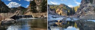
Pike-San Isabel National Forest and Cimarron and Comanche National Grassland, Eleven Mile Canyon and Lower Lake George Watershed Health Improvement Program – FY2022: $500,000
The South Park Ranger District has worked with multiple partners to plan for and develop adaptive watershed improvement projects within the South Platte River and Tributary watersheds downstream from Eleven Mile Reservior. These watersheds are identified as high wildfire risks as well as high resource values such as municipal water quality and wild trout waters. Partners include Colorado Springs Utilities, Denver Water, Colorado Parks and Wildlife, Colorado State Forest Service, The Nature Conservancy, the Coalition for the Upper South Platte, Trout Unlimited, as well as other various non-profit organizations, local municipalities, and adjacent private landowners. Projects include the removal of the Lake George Dam, a low-head diversion structure at the mouth of Eleven Mile Canyon, on the mainstem of the South Platte River, restoring approximately 50 miles of fish passage and an estimated 50 miles of water quality improvements.
Shawnee National Forest, Kinkaid Lake Watershed Restoration Action Plan Projects – FY2022: $56,200.
Kinkaid Lake provides potable drinking water to surrounding communities, serving over 30,000 people, as well as recreation opportunities for nearby residents and visitors. Kinkaid Lake Watershed Restoration Action Plan addresses gully mitigation, shoreline erosion control, and lake riparian habitat enhancement to decrease sedimentation and improve the health of riparian areas. Of major concern in the Kinkaid Lake area is the amount and rate of sediment entering the lake. Since the mid-1990's, partnership efforts have protected several miles of shoreline and stabilized thousands of feet of gullies in the watershed. However, there are still thousands of feet of actively eroding gullies, degraded trails, and degraded riparian habitat in the watershed. Projects are important to climate resilience as more frequent, intense storms increase erosion, sedimentation, nutrient inputs to streams and reservoirs, and risk of algal blooms.
Ottawa National Forest, Upper East Branch Ontonagon Priority Watershed Restoration – FY2022: $300,000
Upper East Branch Ontonagon Priority Watershed Restoration plan implements projects in three adjacent priority watersheds in the Upper East Branch Ontonagon River. The Ottawa National Forest in partnership with Trout Unlimited and The Nature Conservancy aims to improve connected habitat in this watershed. Changing water temperatures, due to climate change and the conditions of the local watershed, are at risk of no longer supporting native species. The Lower Dam Removal Project will improve stream function and benefit cold-water communities by providing access to 6.8 miles of high-quality habitat. Riparian vegetation enhancement projects will maintain cold-water habitat by planting long-lived conifer species in riparian zones.
Custer Gallatin National Forest, Shields River Watershed Restoration Project – FY2022: $550,000
The Shields River and its tributaries form an extensive stream system with historic habitat for native Yellowstone Cutthroat Trout. The approved aquatic organism passage projects will be the final essential projects needed to complete the Watershed Restoration Action Plan and an overall massive restoration effort which will allow native trout and other organisms to access higher elevation reaches and increase resiliency to climate change impacts on stream temperature. Restoration of Yellowstone Cutthroat Trout will begin in July of 2022 with expected completion in 2024.
Beaverhead-Deerlodge National Forest, Conservation Strategy for Bull Trout on National Forest System lands
in Western Montana – FY2022: $107,471
The Beaverhead-Deerlodge National Forest is partnering with Trout Unlimited and a larger coalition of stakeholders including Montana Fish Wildlife and Parks, Montana Natural Resource Damage Program, Butte-Silver Bow County, and private landowners to implement cooperative projects to retrofit and rebuild irrigation and industrial diversion infrastructure to protect native fish including bull trout and Westslope cutthroat trout at five project locations over the next five years. Warm Springs Creek represent the greatest length of stream in the Upper Clark Fork Core Area, including six spawning reaches in five streams, for local populations of Bull trout.
Habitat fragmentation, isolation of local populations from other populations and the presence of hybridizing and competing species are the main limiting factors to bull trout populations. The Warm Springs Creek Fish Passage Restoration Project will reconnect more than 60 miles of Threatened and Endangered Species Act-listed critical bull trout habitat at the headwaters of the Clark Fork River.
Wallowa-Whitman National Forest, Grand Ronde Headwaters Restoration Partnership – FY2022: $579,411
The Grande Ronde Headwaters Restoration Partnership, built upon 30 years of shared stewardship restoration with 18 county, state, federal, tribal and NGO partners, will restore 129 miles of stream, 496 acres of riparian, wet meadow, floodplain, and upland habitat, and restore fish passage to more than 45 miles of habitat. CALR 2022 funds will be used immediately to restore 15.5 miles of Threatened and Endangered Species Act-critical fish habitat identified in recovery plans, including Snake River Basin Spring Chinook, Snake River Bas summer steelhead, and Columbia River bull trout.
El Yunque National Forest, Ríos Espíritu Santo and Mameyes Restoration Plan – FY2022: $112,418
The Ríos Espíritu Santo and Mameyes Restoration Plan addresses many issues affecting water quality for three adjacent watersheds. Funded activities will complete an inventory of aquatic barriers in the forest and downstream, followed by the removal of barriers and restoration of riparian vegetative habitat. The plan also includes removing invasive plants and plant riparian trees within the riparian buffer zones to decrease sedimentation, improve water quality, and enhance composition. The project will integrate educational efforts to enhance knowledge and modify behaviors of people in local communities regarding their connection to their drinking water. The focus is to improve water quality by having less trash entering streams and decrease the frequency of vehicles driving in streams.
This plan complements an existing Joint Chief project to plant 5,000 rare trees across northeastern Puerto Rico. This plan implements components of the northeastern regional corridor plan for aquatic and terrestrial wildlife, and people. This will be the first corridor to connect ridge to reef, improving environmental justice and drinking water quality.
Uinta-Wasatch-Cache National Forest, Upper Bear River Watershed Restoration – FY2022: $472,500
The Upper Bear River Watershed Restoration Plan will restore fish passage on 58 miles of rivers and streams that have culverts and diversion structures that block the passage of aquatic organisms, and address water quality issues on 75 miles of streams by using a combination of low-tech process-based stream restoration techniques, road reconstruction and realignment, and off-channel ponds. These activities will protect, maintain, or improve a total of over 9,500 acres of water or soil resources. The Upper Bear River is an important conservation area for native Bonneville Cutthroat Trout, Northern Leatherside Chub, and Bluehead Sucker.
Project implementation is a collaborative effort between the Forest Service and partners including Trout Unlimited, Utah Division of Wildlife Resources, U. S. Fish and Wildlife Service, City of Evanston, Natural Resources Conservation Service, Wyoming Department of Game and Fish, Utah State University’s Restoration Consortium, Western Native Trout Initiative, Open Rivers Fund, and numerous private landowners.