
Geologic Wonders
Fishlake National Forest boasts a variety of intriguing geologic features, including volcanic rocks from the Marysvale volcanic field, the Fish Lake Basin formed by faulting, and the Sevier River Formation with its volcanic ash deposits, showcasing a dynamic geological history.
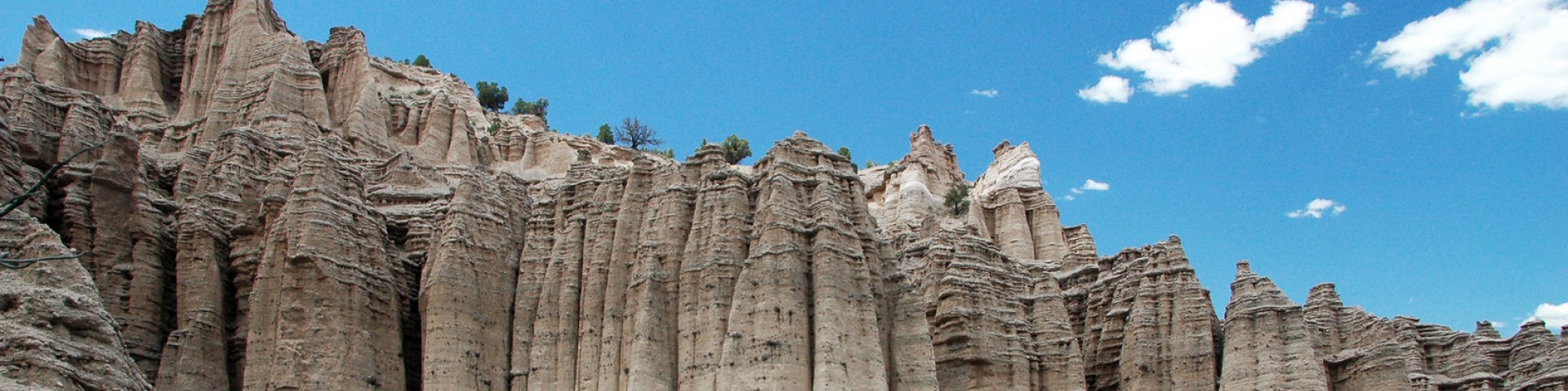
Fish Lake Basin - Geologic History
The interesting aspect of the geology of the Fish Lake Basin is not the rocks that underlie it, for they are all basalts that flowed out of fissures as molten lava then simply lay there until they cooled, but in the processes and movements that formed the basin. The basin is a gigantic trough formed when an elongate block dropped down between two faults. We can see the outline of these faults today as the slopes of Mytoge Mountain, on the southeast side of the basin, and Fish Lake Hightop Mountain, on the northwest side. The block extends from near Johnson Valley Reservoir to Windy Ridge, a length of about 10 miles.
Settling of this basin-forming block has not been uniform or continuous. Rather, it has dropped from the level of the two surrounding mountains in a discontinuous series of jumps that produced earthquakes. Between these jumps were long periods of quiet, such as we are enjoying now. Each end of the basin has not settled the same amount with each jump. We know this because at one time in the not-too-distant prehistory the lake drained out the south end rather than through Lake Creek as it does now. Since the divide in the old stream channel is 50 feet higher than the lake, we know the north end of the basin has recently dropped 50 feet more than the south end.
In addition to faulting, glaciers have also had a big part in shaping the basin. The most prominent one carved out Pelican Canyon and deposited the debris as moraines. These moraines form the low hills at the mouth of the canyon. Pelican Overlook sits on top of these moraines. As the glaciers melted, the waters washed sediment from the moraines out into the lake, forming a fan-shaped deposit. This fan nearly cut the lake in two, but a narrow straight remains at Pelican Point between the main body and Widgeon Bay. Other, less prominent, glaciers occurred near Frying Pan and along the west side of Sevenmile Creek.
Written by Andrew E. Godfrey, Geologist
The dark, somber hues of the rocks comprising Monroe Mountain, also known as the Sevier Plateau, stand in stark contrast to the vivid colors of the Colorado Plateau to the east. This does not mean, however, that the plateau has had a bland history. To the contrary, the mountain has been racked by violent eruptions, earthquakes, and giant landslides.
Beginning about 25 million years ago the area was a scene of intense, explosive volcanic activity. Within what is now called Monroe Mountain there were two main centers, one located around Signal Peak and the other around Langdon Mountain. Eruptions of these volcanoes were so violent that they created their own weather. Clouds of volcanic dust and gasses rose so high that they condensed, forming their own thunderstorms. The resulting torrential floods washed boulders and other debris down the newly formed sides of the volcanoes. Examples of these flood deposits can be seen along the walls of Pole Canyon.
As the eruptions proceeded a tremendous amount of material was removed from the pool of molten lava deep within the earth creating a large void. The overlying rocks subsided into this void much as a piston slides down a cylinder. The resulting depression is called a caldera. Monroe Peak Caldera is tremendous, measuring about 14 miles east-west and 11 miles north-south, from Poverty Flat on the west to Koosharem on the east, and from Tenderfoot Ridge on the north to Big Flat on the south.
This period of violent activity was followed by one of quiet. Erosion reduced the land to an area of low relief where streams slowly meandered. Between the low hills there were swamps and lakes. Gravels and sands were deposited along the stream courses while sands and muds were deposited in the swamps and lakes. This period lasted from about 14 to 7 million years ago and the sediments are known as the Sevier River Formation.
About five million years ago the period of quiescence ended. Forces within the earth lifted and bent large blocks. One such block is Monroe Mountain. On the east side, the rocks dip off to the east and are broken by several small faults that drop the east side downward. The west side, however, is bounded by a truly spectacular fault system. Stretching from about Gunnison to the Grand Canyon, this fault system has dropped the west side relative to the high standing east side. In places there is about two miles of displacement between the two sides. All this movement along the fault did not occur at one time. Only about 20 feet or less normally happens during one earthquake. Over several million years, with the earthquakes happening about once every 400 years, the distance built up.
As the relief between the mountain block and the surrounding valleys built up, the steep mountain slopes became more unstable. Repeated shakings by earthquakes loosened slope material and sent it crashing down as some of the larger landslides in the state of Utah. Thompson Creek Landslide near Monroe (this one is supposed to be the largest in Utah), Elbow Landslide near Marysvale, and The Brink near Burrville are the largest. There are numerous other landslides ringing Monroe Mountain. Thus, the gently rolling top of Monroe Mountain stands in stark contrast to the steep slopes surrounding it.
-Written by Andrew E. Godfrey, Geologist
The Pahvant Range runs from Clear Creek Canyon at the south to Scipio Pass on the north. From there, the Canyon Mountains extend northward to the Sevier River at Leamington Canyon, the lowest point in the Fishlake National Forest. The Pahvant Range truly has a split personality, as the rocks on the west side are over twice as old as those on the east.
The eastern front of an ancient mountain range runs down the center of the Pahvant Range of today. West of this front, the rocks are limestones, quartzites, sandstones, and shales that were deposited below sea level in a gradually deepening ocean basin called a geosyncline. Compressive forces of continental collision thrust huge sheets of this sedimentary sequence up and over other sheets to form high mountain ranges. East of this front, the rocks are conglomerates, sandstones, and shales shed off these ancient mountains and deposited at their base. Because this debris was deposited on land, much of it is colored red and yellow, in contrast to the drab grays and tans of the marine deposits on the west side of the Pahvant Range.
A second difference between the two sides of the range is that the rocks on the west side are contorted and stand vertically in many places due to over thrusting. On the east side, the rocks are flat lying or dip slightly to the east, due to subsequent uplift. Thirdly, the Paleozoic rocks, on the west side, are well indurated so they form numerous high cliffs and steep slopes while the Tertiary rocks to the east are generally not as well indurated so the slopes are generally more rounded. Shortly after the deposition of these Tertiary rocks, the Pahvants were uplifted along block faults to form the range we see today and to start the present period of erosion. Since this mountain block is lighter than the blocks on either side, it is continuing to rise and the bounding faults are still active.
The Canyon Mountains were formed from the same material and in the same manner as the Pahvant Range. The main difference is that the bulk of these mountains are composed of the overthrust Paleozoic sequence. Because they lie west of the Pahvant only their northeast corner is composed of debris shed off the mountain front. The Church Hills area, at the south end of the Canyon Mountains, is also underlain by mountain debris, but this material is much younger and was deposited as basin fill after the area had been uplifted and closed basins formed.
-Written by Andrew E. Godfrey, Geologist
The geologic history of the Salina Canyon area probably sounds more like science fiction than true science. And maybe it should start out: "Long ago and far away." For what is now a high desert more than a thousand miles from the ocean was once a humid coastal swamp at the edge of the sea. Where deer, elk, and cougar now roam, dinosaurs once thundered. Where Salina Creek flows to the west, a mighty river once flowed to the east. All this occurred when the rocks underlying the canyon were deposited, about 65 million years ago.
Sixty-five million years ago was about the end of the period geologists call the Cretaceous. Dinosaurs were about to become extinct. Collision of continental plates on the west coast of North America had thrust up high mountains in what is now Nevada and western Utah. Rivers draining these mountains flowed to a seaway that extended from the Gulf of Mexico to the Arctic Ocean. It covered eastern Utah and much of Colorado. Oysters and the teeth of sharks and sting rays are found in the mud deposited on the floor of this sea.
The area now occupied by Salina Canyon was part of a coastal plain between the mountains and the sea. It teamed with life; was probably quite humid, hot and abounded with bugs and creepy things. Like the present day delta of the Mississippi River, the area was swampy with islands of vegetation. Sand and mud bars accumulated alongside a mighty river that emptied into the sea. Dense jungles grew and sunk into swamps so rapidly that there was not time for decomposition of the vegetation. Thick coal seams today give evidence of the tremendous volumes of organic material produced. As sea level fluctuated, beaches advanced or retreated over the future coal beds burying them. Sediment forming these beaches was delivered by the mighty rivers coming from the mountains to the east.
Since that time the whole area known as the Colorado Plateau has been uplifted over a mile. This, along with the rotation of the North American continent to another location, has changed the area from a hot, humid coastal plain with abundant rainfall to the high altitude desert we see today.
-Written by Andrew E. Godfrey, Geologist