Visitor Maps and Guides
Get ready for your visit by checking out our detailed maps, brochures, and information guides. Visitor maps and publications are available in-person at forest offices and online at the US Geological Survey Map Store or Discover Your Northwest Online Store.
The MVUM is FREE to the public. In addition, the MVUM can be downloaded to a mobile device, such as an iPad, iPhone, iPod Touch or Android (4.0.3 or newer), directly through the Avenza PDF Maps Mobile App. The Forest also created files that can be viewed in Google Earth and compatible with newer Garmin Global Positioning System (GPS) units.
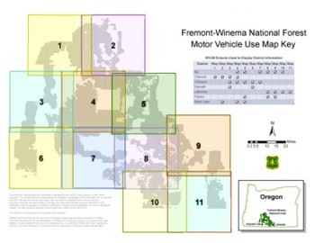
| MAP 1 | Map 2 | Map 3 | Map 4 | Map 5 | Map 6 |
| Map 7 | Map 8 | Map 9 | Map 10 | Map 11 |
If you own a mobile device such as an iPad, iPhone, iPod Touch or Android (4.0.3 or newer), you can take the MVUM with you.
- Download the free Avenza PDF Maps App, available at http://www.avenzamaps.com to your mobile device.
- Once you have Avenza on your mobile device, use your device to download the maps while running the App. Search for “Fremont-Winema MVUM” to download all 11 MVUMs.
With the app and maps installed on your mobile device, you will be able to:
- View your location on the PDF MVUM using the built-in GPS device
- Measure distances and areas
- Plot waypoints
- View maps offline
- And more…
Through a no-cost contract with Avenza Systems, Inc., the USDA Forest Service has made electronic versions of its Motor Vehicle Use Maps (MVUMs) available as free downloads for smartphones and tablets.
Forest Visitor Maps
Search for Forest Service Visitor, District, Wilderness or other specialty maps online via the US Geological Survey Map Store. Search for a specific National Forest Visitor map using our online Map Finder.
Mobile Friendly Maps

Download available forest & grassland maps to your mobile device via the Avenza app. Available maps include: Forest, Wilderness, District, Winter Recreation, and Motor Vehicle Use Maps.
Free Topo Maps

These free downloadable geo-enabled quadrangle maps are created by the Forest Service. FSTopo is an automated map product using inter-agency authoritative data and is updated annually.


