
Sweet Creek Trail-Beaver Creek Falls Trailhead
This is the trailhead for the Beaver Creek Falls segment of the Sweet Creek Trail #1319
General Information
Within developed recreation sites, dogs must be on a leash no longer than 6 feet, or otherwise under physical restrictive control. 36 CFR 261.16(j)
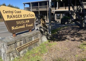
Address: 1130 Forestry Lane Waldport , OR 97394
Phone: (541) 563-8400
Hours: Monday–Friday, 8:00 a.m. – 4:00 p.m. (Closed on federal holidays)
Office Email: r6_siuslaw_wwweb_front_desk@usda.gov
Getting There
Directions
Travel Highway 126 to Siuslaw River Bridge in Mapleton, OR (15 miles east of Florence, OR or 46 miles west of Eugene, OR). Cross the bridge from town and make immediate turn west on Sweet Creek Road. After 10.2 miles, Homestead Trailhead is on the right. Continue on Sweet Creek Road to Sweet Creek Falls and Wagon Road Trailheads. To access the trail at the Beaver Creek Falls Trailhead, drive 0.2 miles beyond the Wagon Road Trailhead, then take the first fork left for 0.5 mile to the parking area.
Facility and Amenity Information
Accessibility
Restrooms
Restrooms are not available at this site.
Water
Potable water is not available at this site.
Picnic Tables
Picnic tables are not available at this site.
Horse/Pack Animal Information
Horse/Pack animals are not allowed at this site.