
Planning
Land and Resource Management plans are required by the National Forest Management Act (NFMA) for each individual National Forest. Over time, individual Forest plans have been amended by other regional plans such as the Northwest Forest Plan. Both national and regional policy guide management of individual National Forests. Forest plans establish land allocations, goals and objectives, and standards and guidelines used by land managers, other government agencies, private organizations and individuals. Planning documents provide direction at a broad scale: regional, forest-wide, or watershed level.
Umpqua National Forest Plan

The Forest Plan guides all natural resource management activities on the Forest. It establishes management standards and guidelines for the Forest and includes goals, objectives, and desired future conditions for each of the management areas on the Forest.
Monitoring Reports

The Forest produces biannual monitoring reports. These reports provide the necessary information to evaluate whether Forest Plan components are effective and appropriate, and whether management is being effective in maintaining or achieving progress toward the desired conditions and objectives for the Forest.
Northwest Forest Plan

In 1994, the Northwest Forest Plan amended the planning documents of the National Forests and Bureau of Land Management districts in the Pacific Northwest. Its mission was to coordinate management direction within the range of the northern spotted owl in order to meet the dual needs for forest habitat and forest products. After more than 30 years, the Northwest Forest Plan needs to be updated to accommodate changed ecological and social conditions.
Travel Management Planning
The Travel Management Rule establishes a designated system of roads, trails, and areas that are open to motorized vehicle use. The Motor Vehicle Use Map, which identifies the locations open to motor vehicle use by type of vehicle and time of year, is based on these designations. Local communities and other government agencies were involved in this designation process.
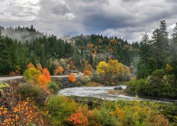
North Umpqua River Management Plan
The North Umpqua River was designated a National Wild and Scenic River in 1988. This river management plan establishes a comprehensive approach to manage the river’s natural character. It details specific management direction and resource monitoring for each segment of the river from the Soda Springs powerhouse downstream to the river's confluence at Rock Creek.