

Safety and Outdoor Ethics
Know Before You Go
The Arapaho and Roosevelt National Forests and Pawnee National Grassland want visitors' experiences to be memorable and safe. Be aware of and prepared for safety concerns before you head out.
Current Conditions

Check road status, trail conditions, and more
Trip Planning
- Visit recreation to find an activity and area to visit.
- Continue reading below for trip planning resources and considerations before you head out.
Roads
- Check Forest Service Road Status. We close roads seasonally, for storm damage, or other situations that may arise.
- Our MVUMs are another great resource for road closure information and to see what types of vehicles we allow on our roads.
- Check state road status at CoTrip. You’ll likely take a state or county road to reach our forest roads, so make sure they're open.
Trails
- Trail Conditions - With over 1,300 miles of trails, specific conditions aren't available, but we do have many great partners who help provide additional information.
- Poudre Wilderness Volunteers hike trails on the Canyon Lakes Ranger District.
- Indian Peaks Wilderness Alliance patrol trails in the James Peak and Indian Peaks Wilderness areas on the Boulder and Sulphur Ranger Districts.
- Trail Information - CoTrex is a great resource for information on trails throughout Colorado. Additionally, select an opportunity on our recreation page to see the associated trails and information.
- Stick to Trails. Walk through snow and mud.
- Wear appropriate footwear for wet conditions.
- Avoid stepping on vegetation if you need to step off-trail to let others pass.
- Step back on trail immediately after people pass you.
General and recurring closures, regulations, and special orders
- Visit Alerts to see prohibitions, closures, and regulations for the Forest.
- Visit Recreation to see if the area you’re visiting requires a pass or reservation.
- Looking for permits for events, photography, firewood collection, or other special use? Visit Permits.
- Some sites use scan and pay for day-use fees. Be sure to download the app ahead of time as cellular coverage can be spotty.
- View campground status at Current Conditions.
- Visit recreation.gov for campground reservations and more.
- Check Fire Restrictions to see if the area you’re visiting allows campfires.
- Check local fire restrictions that may apply to National Forest System lands.
- Check our Alerts to monitor wildfire and prescribed burn closures.
- Have a map - Have more than one way to navigate. Download maps, or buy maps online.
- Have a backup plan - Have an alternate plan in case trailhead parking lots, campsites, etc. are full.
- Leave no trace - Pack it in, pack it out.
- Keep wildlife wild - Colorado Parks and Wildlife is a great source to learn more about hunting, fishing and the wildlife you may encounter on your visit.
- Camping and Hiking in Bear Country.
- Proper food and trash storage required.
- Prepare for unpredictable weather - Colorado's weather is unpredictable and can change quickly. Make sure to bring food and water. Wear appropriate clothing and shoes for cold or wet weather. Check local weather and continue to monitor.
- You might not have cell service - Many areas on the Forests and Grassland don't have cell coverage.
- In the winter, it is important to check avalanche conditions and know how to play it safe on the ice!
- Review Forest Service safety reminders.
Wildlife Safety

Rattlesnake
Many animals call the Forests and Grassland home. Please respect wildlife while visiting and ensure you are safe while in their habitat.
Wildlife experts recommend keeping at least 100 yards away from bears and big game and 25 yards from other animals. With your arm fully extended, you should be able to cover the entire animal with your thumb.
Besides the animals listed below, other animals like rattlesnakes pose safety risks you should be aware of. Colorado Parks and Wildlife is a great resource for more information.
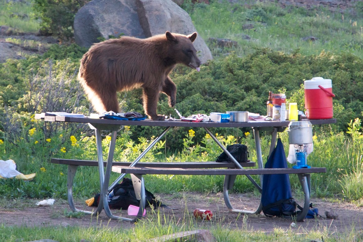
Bears are opportunists: they will feed on whatever is readily available. Food odors and improperly stored garbage will attract bears to campgrounds and picnic sites. Bears become habituated to human food if it is available.
Black bears are found throughout the Forest, and the potential for bear-human interactions is high. Although bears are naturally afraid of humans, the animals lose this fear as they begin to associate human scents with the reward of food. Bears can become a threat to humans, property and themselves—a pattern that normally ends with death to the bear.
The Arapaho Roosevelt Pawnee has a Bear-resistant Food Storage Order, so make yourself familiar with the rules associated with storing food in bear country.
Protect yourself and protect the black bears by storing trash and food in safe locations when you visit a national forest. Visit the CPW Living with Wildlife and How to be Bear Aware in Black Bear Country for additional safety information.

These moose take a break in the Long Draw area on our Canyon Lakes Ranger District.
Moose, the largest members of the deer family, can be found throughout the Arapaho and Roosevelt National Forests. Moose encounters with people are common. Most encounters are peaceful, however, moose can become aggressive and are very powerful.
Moose need their space. They can move quickly - up to 35 miles per hour - and must be given respect.
To avoid a conflict with a moose:
- Ensure your dog is leashed, the mere presence of a dog can increase the potential for conflict.
- Stay a safe distance away and do not approach. If possible, face the animal and back away slowly.
- Avoid surprising wildlife.
Mountain lions call the Arapaho and Roosevelt National Forests home. Although your chances of encountering a mountain lion are small, attacks have been on the rise as humans increasingly enter these cats’ territory.
- Do not hike alone. Go in groups, with adults supervising children.
- Avoid dawn and dusk excursions.
- Keep children close to you. Pick up small children. The mountain lion will see small children as easier prey.
- Do not approach a lion. Most mountain lions will try to avoid confrontation, so give them a way to escape.
- Do not run from a lion. Running may stimulate a mountain lion's instinct to chase.
- Do not crouch down or bend over. A human standing does not resemble a mountain lion's natural prey.
- Do all you can to appear large. Raise your arms. Open your jacket if you are wearing one. Wave your arms slowly and speak firmly in a loud voice.
- Fight back if attacked. Mountain lions usually try to bite the head or neck; try to remain standing and face the attacking animal.
Be Bear Aware

View food storage regulations and bear tips
Leave No Trace

Follow Leave No Trace principles
Closure Orders & Prohibitions
Federal Prohibitions and Special Orders describe the prohibitions, closures, and regulations for the Forest
Frequently Asked Questions
Check here for some of the most common questions we hear.