-
Oak Creek Glass Container Prohibition
Glass containers are prohibited within 300 feet of Oak Creek except within a developed campground or picnic area.
Alert Start Date: December 21st, 2022
Alert End Date: December 20th, 2027
Order Number: 03-04-06-22-30
Associated Documents
Forest Order
U.S. Department of Agriculture, U.S. Forest Service
Coconino National Forest
Red Rock Ranger District
Oak Creek Glass Container Prohibition
PROHIBITIONS
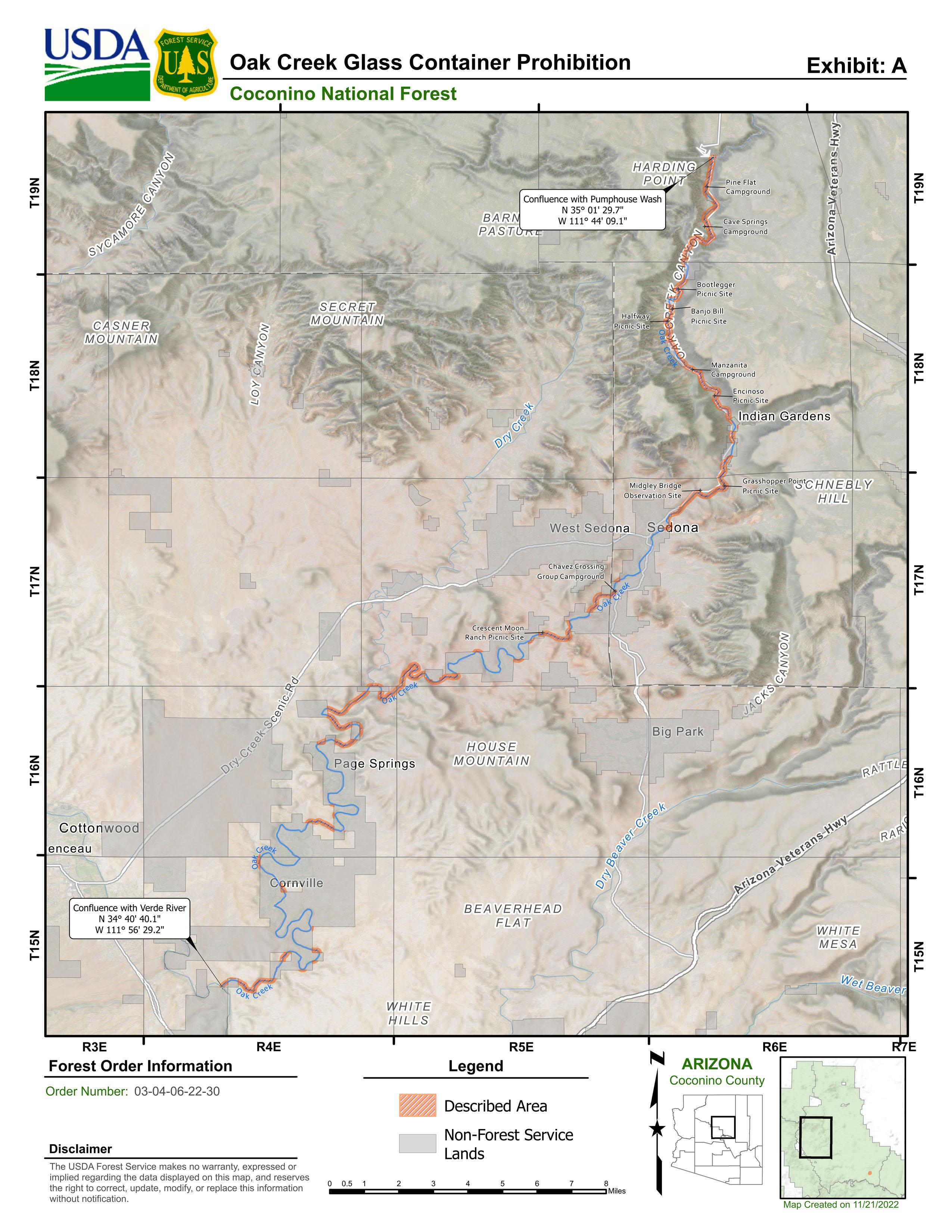
Pursuant to 16 U.S.C. § 551 and 36 C.F.R. § 261.50(a), the following is prohibited on the National Forest System (NFS) lands in the Red Rock Ranger District, Coconino National Forest, described below and shown on the attached map incorporated into this Order as Exhibit A (the “Described Area”):
- Possessing or storing glass containers. 36 C.F.R. § 261.58(cc).
EXEMPTIONS
Pursuant to 36 C.F.R. § 261.50(e), the following persons are exempt from this Order:
- Persons with Forest Service Permit No. FS-7700-48 (Permit for Use of Roads, Trails, or Areas Restricted by Regulation or Order), specifically exempting them from this Order or a written determination by a Forest Service authorized officer that a permit is not required under 36 C.F.R. § 251.50(e)(1) or (2).
- Any Federal, State, or Local Officer, or member of an organized rescue or firefighting resource in the performance of an official duty.
- Possession of glass containers within a motor vehicle or within the following Forest Service developed recreation sites: Pine Flat Campground, Cave Springs Campground, Bootlegger Picnic Site, Banjo Bill Picnic Site, Halfway Picnic Site, Manzanita Campground, Encinoso Picnic Site, Grasshopper Point Picnic Site, Midgley Bridge Observation Site, Chavez Crossing Group Campground, Crescent Moon Ranch Picnic Site.
DESCRIBED AREA
All NFS lands within 300 feet from the center of Oak Creek, beginning at the State Highway 89A Bridge, which marks the confluence of Oak Creek and Pumphouse Wash (35°01'29.7"N; 111°44'9.1"W), continuing downstream in a southwestern direction for approximately 51 miles to the confluence of Oak Creek and the Verde River (34°40'40.1"N; 111°56'29.2"W).
PURPOSE
To ensure public health and safety and improve habitat conditions for aquatic species in the aquatic and riparian environment.
IMPLEMENTATION
- This Order shall be in effect from December 21, 2022 at 5:00 PM through December, 20th 2027 at 8:00 AM, unless rescinded.
- A map identifying the Described Area is attached and made part of this Order as Exhibit A. For a digital version of this Order, go to: https://www.fs.usda.gov/alerts/coconino/alerts-notices.
- Unless otherwise expressly defined in this Order, the terms used in this Order are defined by the regulations of the Secretary of Agriculture, 36 C.F.R. Chapter II, Parts 200-299. If there are terms in this Order that are not expressly defined in the Order or 36 C.F.R. Chapter II, Parts 200-299, their meaning shall be determined by their plain language definitions.
- A violation of the above prohibition is punishable as a Class B misdemeanor by a fine of not more than $5,000 for individuals and $10,000 for organizations, or by imprisonment for not more than six months, or both. 16 U.S.C. § 551; 18 U.S.C. §§ 3559, 3571, and 3581.
- Contact the Coconino National Forest Supervisor’s Office in Flagstaff, AZ at (928) 527-3600 for more information about this Order.
- This Order supersedes any previous Orders prohibiting the same or similar acts in the same Described Area.
Signed and issued on December 21, 2022.
LESLEY YEN
Acting Forest Supervisor
Coconino National Forest
Contact Name:
Red Rock Ranger DistrictContact Number:
928-203-2900Maps
Images below will open full size in a new window.