-
Occupancy and Use Prohibition: San Francisco Peaks Alpine Tundra and Inner Basin Restrictions
Use restrictions are in effect for the San Francisco Peaks Inner Basin area.
Alert Start Date: December 17, 2024
Alert End Date: December 17, 2029
Order Number: 03-04-08-24-04
Associated Documents
Forest Order
U.S. Department of Agriculture, U.S. Forest Service
Coconino National Forest
Flagstaff Ranger District Occupancy and Use Prohibition:
San Francisco Peaks Alpine Tundra and Inner Basin Restrictions
PROHIBITIONS
Pursuant to 16 U.S.C. § 551 and 36 C.F.R. § 261.50(a), the following are prohibited on the National Forest System (NFS) lands in the Flagstaff Ranger District in the Coconino National Forest, described below and shown on the attached map incorporated into this Order as Exhibits A and B (the “Described Areas”):
- Going into or being upon an area. 36 C.F.R. § 261.53(a).
- Camping. 36 C.F.R. § 261.58(e).
- Riding, hitching, tethering or hobbling a horse or other saddle or pack animal. 36 C.F.R. § 261.58(aa).
EXEMPTIONS
Pursuant to 36 C.F.R. § 261.50(e), the following persons are exempt from Prohibition (1) of this Order (Going into or being upon an area. 36 C.F.R. § 261.53(a)) as described below and shown on the attached map incorporated into this Order as Exhibit A:
- Persons with Forest Service Permit No. FS-7700-48 (Permit for Use of Roads, Trails, or Areas Restricted by Regulation or Order), specifically exempting them from this Order or a written determination by a Forest Service authorized officer that a permit is not required under 36 C.F.R. § 251.50(e)(1) or (2).
- Any Federal, State, or Local Officer, or member of an organized rescue or firefighting resource in the performance of an official duty.
- Persons hiking and staying on Forest System Trails.
- Persons hiking, skiing or snowshoeing on snow cover.
Pursuant to 36 C.F.R. § 261.50(e), the following persons are exempt from Prohibition (2) of this Order (Camping. 36 C.F.R. § 261.58(e)) and Prohibition (3) of this Order (Riding, hitching, tethering or hobbling a horse or other saddle or pack animal.36 C.F.R. § 261.58(aa)) as described below and shown on the attached map incorporated into this Order as Exhibit B:
- Persons with Forest Service Permit No. FS-7700-48 (Permit for Use of Roads, Trails, or Areas Restricted by Regulation or Order), specifically exempting them from this Order or a written determination by a Forest Service authorized officer that a permit is not required under 36 C.F.R. § 251.50(e)(1) or (2).
- Any Federal, State, or Local Officer, or member of an organized rescue or firefighting resource in the performance of an official duty.
- Authorized grazing allotment permittees actively engaged in the removal of strayed livestock.
DESCRIBED AREAS
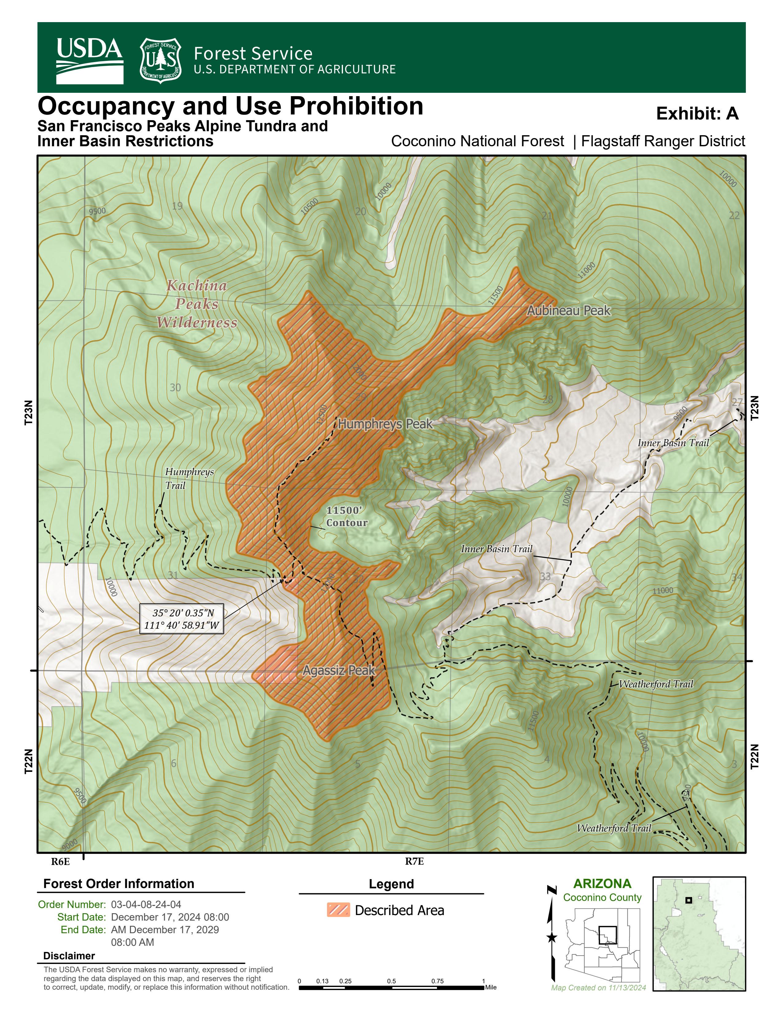
As depicted on the map in Exhibit A, going into or being upon an area (36 C.F.R. § 261.53(a)) is prohibited within the Described Area including all NFS lands within the boundary starting at the intersection of the Humphreys Trail and the 11,500 foot elevation contour (35° 20’ 0.35”N; 111° 40’ 58.91”W), thence following the 11,500 foot elevation contour northerly, thence trending clockwise, to encompass Humphreys Peak, Abineau Peak, and Agassiz Peak, intersecting at the 11,500’ contour and the Weatherford Trail, then continuing to the Described Area point of origin at the intersection of the Humphreys Trail and the 11,500 foot elevation contour. The 11,500 foot elevation contour is defined on the ground as being the tree line boundary. The tree line boundary is defined as the area above which trees are not found and the area consists predominantly of low growing grasses, herbs, and forbs.
As depicted on the map in Exhibit B, camping (36 C.F.R. § 261.58(e)) and riding, hitching, tethering or hobbling a horse or other saddle or pack animal (36 C.F.R. § 261.58(aa)) is prohibited within the Described Area including all NFS lands within the boundary starting at the intersection of the Inner Basin Trail (Trail #29) and the Waterline Trail (Trail #146) (35° 20’ 46.73”N; 111° 38’ 22.76”W), thence continuing 225 feet southwest to the intersection of the Kachina Peaks Wilderness boundary, thence following the Kachina Peaks Wilderness boundary easterly, thence trending clockwise along the Wilderness boundary to (35° 20’ 53.13”N; 111° 38’ 39.1”W), thence continuing due east 140 feet to the Waterline Trail (35° 20’ 53.14”N; 111° 38’ 37.42”W), thence following the Waterline Trail southeast for 2,950 feet to the Described Area point of origin at the intersection of the Waterline Trail and the Inner Basin Trail.
PURPOSE
The purpose of this Order is to preserve habitat for threatened and endangered species and protect watershed quality and function.
IMPLEMENTATION
- This Order shall be in effect from December 17, 2024 at 0800 through December 17, 2029 at 0800, unless rescinded.
- Maps identifying the Described Area are attached and made part of this Order as Exhibits A and B. For a digital version of this Order and Exhibits A and B, go to: https://www.fs.usda.gov/alerts/coconino/alerts-notices.
- Unless otherwise expressly defined in this Order, the terms used in this Order are defined by the regulations of the Secretary of Agriculture, 36 C.F.R. Chapter II, Parts 200-299. If there are terms in this Order that are not expressly defined in the Order or 36 C.F.R. Chapter II, Parts 200-299, their meaning shall be determined by their plain language definitions.
- A violation of the above prohibitions is punishable as a Class B misdemeanor by a fine of not more than $5,000 for individuals and $10,000 for organizations, or by imprisonment for not more than six months, or both. 16 U.S.C. § 551; 18 U.S.C. §§ 3559, 3571, and 3581.
- Contact the Coconino National Forest Supervisor’s Office in Flagstaff, AZ at (928) 527-3600 for more information about this Order.
- This Order supersedes any previous Orders prohibiting the same or similar acts in the same Described Area.
Signed and issued on December 17, 2024
AARON W. MAYVILLE
Forest Supervisor
Coconino National Forest
Contact Name:
Flagstaff Ranger DistrictContact Number:
928-526-0866Maps
Images below will open full size in a new window.