

Slate Mountain Trail No. 128
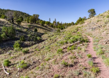
Though this trail has a humble beginning at an old roadblock, it quickly reveals itself to be one of the Coconino National Forest's premier day hikes. Actually an old jeep track, now used solely as a foot trail, this 2.4-mile climb is a gradual but steady ascent along a wide gravel track to some of the best views on the forest. Interpretive signs along the way add a bit of educational interest by naming trailside species of trees and shrubs.
Near the top of the climb, the path spirals up the mountain's narrow summit like a stripe up a barber pole. The effect is as if you were riding past some of the Forest's most spectacular scenery on a huge lazy Susan. The San Francisco Peaks, Kendrick Mountain, Red Mountain, the Grand Canyon, Painted Desert, you can see them all, just by turning your head, from the top of Slate Mountain.
Photo Gallery


Specific Trail Information
Trail Number
Trail Type
General Information
- Difficulty: Easy to moderate (due to elevation).
- Trailhead Elevation: 7,362 ft.
- Elevation Gain: 853 ft.
- Length: 2.4 miles one way.
- Time: 2-3 hours.
No motorized vehicles are allowed on this trail.
Address: 5075 N. Highway 89, Flagstaff, AZ 86001
Phone: 928-526-0866
Hours: Monday-Friday, 8 a.m. - 4 p.m. (Closed on federal holidays)
Office Email: SM.FS.Cof_Webmail@usda.gov
Getting There
Directions
Location: 37 miles (about 45 minutes) north of Flagstaff between the Grand Canyon and the San Francisco Peaks.
Access: Drive 35 miles north of Flagstaff on U.S Highway 180 to Forest Road 191. Turn west 2 miles to the trailhead on the right side of the road. US 180 is paved. FR 191 is graveled and suitable for passenger cars in most weather.
GPS (Map): 35°29'09.5"N 111°50'10.3"W