Recreation
Recreation Regions
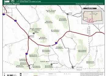
Click on the map image to see the different Recreation Regions for the Coronado National Forest. The regions are divided by mountain ranges, which will allow visitors to explore all the recreation opportunities within those ranges.
Cañada del Oro #4
This old trail follows the drainage of the Cañada del Oro, or Canyon of Gold, down the north slopes of Mt. Lemmon toward the town of Oracle. Besides being the site of a legendary lost gold mine,…
Canelo Hills Loops #799/58/49 Scenic Drive
Historic ranching and mining country with broad grasslands and distant buttes provides the setting for this loop drive. The route starts out in the little ranching community of Sonoita and winds…
Canelo Ranger Office
Tucked off the road on the west side of Turkey Creek, the bungalow-style building from the 1930s continues to greet visitors from near and far. This former ranger’s office has three rooms,…
Canelo Ranger Residence
Built in the 1930s by the Civilian Conservation Corps (CCC), the Canelo Ranger Residence was once home to the Sierra Vista District Ranger. The six-room residence has two bedrooms, a bathroom, a…
Carr Canyon Perimeter Trailhead
The Carr Canyon Perimeter Trailhead provides access to the Perimeter Trail #138 and the Carr Nature Trail #139. There is no fee or pass required to park at this location. Trash bins are available at…
Carr Canyon Picnic Area
Carr Canyon Picnic Area is nestled in an oak forest near the base of the Huachuca Mountains. The site offers 11 picnic sites with tables and grills, a restroom, and nearby hiking trails.
Carr Canyon Road #368 Scenic Drive
Download the Carr Canyon Visitor Guide in English.Descarga la guía del visitante en español a Carr Canyon. If you look up at the Huachuca Mountains from the town of Sierra Vista, a band of sheer…
Carr House
The historic Carr House, which now operates as an information center on weekends from early spring through late fall, offers exhibits and information relating to the local area in its lovely…


