

Mount St. Helens National Volcanic Monument & Surrounding Area
The Mount St. Helens National Volcanic Monument and District contains many wonderful places to see and explore. On the west side of Mount St Helens you can drive into the heart of the blast zone via State Route 504. The eastern side of the mountain offers summer and fall opportunities to view the crater and Spirit Lake, visit interpretive sites, and various hiking trails. South of Mount St. Helens visitors will find lava flows, lush forests and multiple recreation opportunities year-round including winter recreation. Mount Margaret Backcountry area offers rugged, steep trails and amazing landscapes that typify the rugged backcountry.
About the Mount St. Helens 1980 Eruption & Aftermath
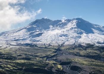
On the morning of May 18, 1980, a magnitude 5.1 earthquake triggered the collapse of the summit and north flank of Mount St. Helens and formed the largest landslide in recorded history. In 1982 Congress designated the 110,000-acre Mount St. Helens National Volcanic Monument. The following decades have offered insight into the biological recovery of ravaged landscapes.
Active Alerts
Mount St Helens


General Information
Mount St. Helens National Volcanic Monument Headquarters, (360) 449-7800
View a vicinity map of Mount St. Helens National Volcanic Monument (PDF)
Check out the Volcano Review: A Visitors Guide to Mount St. Helens National Volcanic Monument.
Passes & Permits
Permit Info:
- Washington State Sno-Park Permits required at Sno-Parks Dec. 1-March 31. NOT available on-site.
- Permits are required year-round to climb Mount St. Helens. In peak season, April 1-Oct. 31, permits are only available online.
- Camping in the Mount Margaret Backcountry requires a backcountry permit.
Fees:
- $5/vehicle/day at most developed recreation sites, or a valid Recreation Pass. See Mount St. Helens Map for fee and payment sites.
- Commercial Bus Tour Groups
Complexes
Drive into the heart of the blast zone. Spectacular crater views, visitor centers, picnic areas and hikes await. Visit the Mount St. Helens West: State Highway 504 for more detailed information and learn what's open along State Route 504.
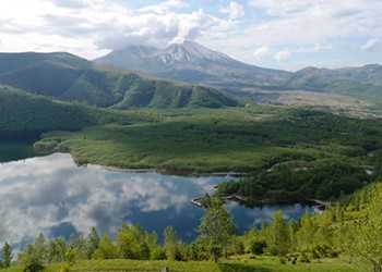
Visit the Science and Learning Center at Coldwater and various recreation sites such as the Hummocks Trail, Coldwater Lake, South Coldwater Trailhead and access Mount Margaret Backcountry.
See the Mount St. Helens East: Forest Roads 25 & 99 for information about the Mount St. Helens National Volcanic Monument's vast blown down forest and views of the legendary Spirit Lake and access to Mount Margaret Backcountry.
On Forest Road 99, there are 8 interpretive sites to enjoy views and learn about the volcano including: Bear Meadow Interpretive Site, Blast Edge Viewpoint Monument Entry, Miners Car Interpretive Site, Meta Lake Interpretive Site, Cascade Peaks, Harmony Falls Viewpoint, Smith Creek Picnic and Viewpoint, and Windy Ridge Interpretive Site.
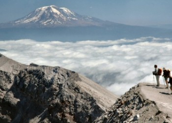
Visit the Mount Margaret Backcountry Page for more information about the backcountry's spectacular views of the Mount St. Helen's blast zone, Spirit Lake and Mount Adams.
Lava flows, waterfalls, caves, and lush forest abound. Visit Mount St. Helens South: Forest Roads 83 & 81 for more information about unique recreation opportunities on the south side of Mount St. Helens.
Key sites in this area include: Ape Cave, Trail of Two Forests Interpretive Site, June Lake Trail, Lahar Viewpoint, Ape Canyon Trail, Lava Canyon Interpretive Site, Climber’s Bivouac Trailhead, Blue Lake Trailhead, and Kalama Horse Camp Campground.