Recreation
Recreation Regions
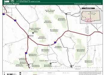
Click on the map image to see the different Recreation Regions for the Coronado National Forest. The regions are divided by mountain ranges, which will allow visitors to explore all the recreation opportunities within those ranges.
Agua Caliente #140
Provides access to the upper slopes of Mt. Hopkins, the second most prominent peak in the Santa Ritas. The Agua Caliente Trail winds 5.2 miles along the north slopes through a cool forest of…
Alder Picnic Area
This picnic areas is located near the crest of the Santa Catalina Mountains in the cool ponderosa pines within a short drive of trailheads, Ski Valley, and the village of Summerhaven. At this high…
Arcadia #328
Because of the notable views it offers, Arcadia Trail has been designated a National Recreation Trail, placing it among the most outstanding trails in the nation. Most people travel this popular…
Arcadia Campground
Site Open
When early settlers ventured up Mount Graham, the Arcadia area was usually as far as they got on the first day. A little later in the history of the Pinalenos, Arcadia was the site of one of…
Arizona Highway #83 to Montezuma Pass Scenic Drive
The drive from Sonoita to Montezuma Pass passes through an area of rolling hills and shallow canyons where distant mountain ranges mark the horizons. About midway through the drive, Parker Canyon…
Armour Spring #71
The Crest Trail stretches between Florida Saddle at the head of Florida Canyon and the 9,453-foot summit of Mt. Wrightson, the highest peak in the Santa Ritas and one of the highest in southeastern…
Ash Creek #307
One of the Pinaleno range’s larger streams has carved the route for this popular trail. As it drops from alpine forest to desert valley, Ash Creek Trail passes through all of the varied life zones…
Ash Creek Detour #307A
One of the Pinaleno range’s larger streams has carved the route for this popular trail. As it drops from alpine forest to desert valley, Ash Creek Trail passes through all of the varied life zones…


