
Recreation
Listed below are all of our recreation opportunities, in alphabetical order. Click on the designated card to find out more about each one!
The Big Pine region offers a real treat for the more experienced hiker. Middle Palisade Glacier, the southernmost glacier in North America can be…
Bishop is named for rancher Samuel Bishop, a First Sergeant with the Mariposa Battalion, who settled here in the 1860s, when the Owens Valley was…

Named after the famous shoot-out between the escaped convicts and the sheriff’s posse, this is a popular camping and fishing area.
This region encompasses Onion Valley, one of many popular steep canyon roads that lead into the Sierra Nevada.
The Inyo Mountains are a north-south trending desert mountain range between the Owens Valley to the west, and Death Valley National Park to the east.
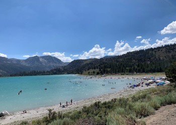
For beautiful alpine scenery, you can’t miss June Lake. Hwy. 158 gives access to a chain of gorgeous lakes nestled in a steep horseshoe-shaped…

Located at the southern end of the Sierra Nevada, the Kern Plateau is vast area of forest covered hills and mountains, punctuated by green meadows.

In the early 1860s, the first settlers of Lone Pine gave the town its name because of a single, large pine tree at the confluence of Lone Pine &…

The long valley Caldera is the massive, depressed area with Mammoth Lakes to the West, Crowley Lake to the Southeast and the Glass Mountains to the…
This region houses Twin Lakes, and Mary, George, Mamie and Horseshoe Lakes, which are located along Lake Mary Road. These lake beds were scooped out…
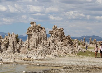
This region encompasses Mono Lake, South Tufa, the Panum Craters, Mono Mills and Tioga Pass. To protect the outstanding geologic, ecologic and…

The Owens River Headwaters region encompasses 14,721-acre wilderness of the same name, designated by Congress on March 31, 2009. It is an area of…

Convenient to both Bishop and Mammoth areas, this region has great camping and fishing.
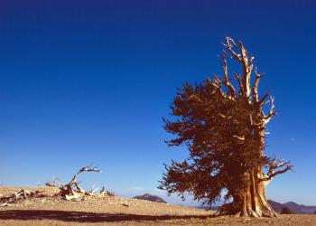
The White Mountains are in arid desert and seem an unlikely place to find the oldest living trees, the bristlecone pines.
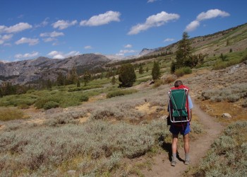
The Pacific Crest Trail, or the PCT, is arguably the most famous of the nation's designated National Scenic Trails. Winding its way through spectacular vistas fr
Recreation
Aerie Crag Picnic Area and Campground
Site Open
Lakeside picnic area along the Rush Creek on June Lake Loop. When local campgrounds are full, this site may be opened as overflow camping for self-contained RV's. 10 sites total, great for…
Agnew Meadow Wildflower Trailhead
Limited access due to construction. See the Reds Meadow Road Reconstruction Project page. This short nature trail through meadow habitat gives the opportunity to see many plant species.
Agnew Meadows Campground
Site Closed
Agnew Meadows Campground includes a Family Campground, a Group Campground, and an Equestrian Campground.It is located in the Reds Meadow Valley, just west of Mammoth Lakes, California. Popular with…
Ancient Bristlecone Pine Forest
Visiting the Ancient Bristlecone Pine Forest is an enjoyable way to spend a day learning about the oldest trees in the world. Living trees exceed 4000 years of age with weathered, twisted, and…
Aspen Campground
Site Open
45 campsites that can accommodate a 40-foot vehicle and have a bear locker, are available. Drinking water is not available. Vault toilets are available. This is Bear Country. Please store food…
Aspen Group Campground
Site Open
Situated at an elevation of 8,100 feet, Aspen offers views of massive peaks to the west and surrounding steep canyons. The group site is located in Rock Creek Canyon. Aspen Group Campground is a…
Baker Lakes Trail
Several different access points lead to the Baker Lake area.Starting from Big Pine Creek and Glacier Lodge, the Baker and Green Lakes trail climbs several miles of sage-covered slopes outside of…
Bald Mountain Road
23 miles round trip loop, Trail D. The views along this route are stunning. Perfect route for snowmobiling and winter use.
Baxter Pass Trail
The Baxter Pass Trail provides access to the John Muir Wilderness. It climbs more than 6,000 feet to Baxter Pass, on the Sierra Crest. The trail continues into Kings Canyon National Park, where it…
Beck Lake Trail
This trail goes to Superior Lake from which you can access Beck Lakes.From Shuttle stop #6 in front of the Devils Postpile Visitor Center it is less than a mile to the junction with the John Muir…