
Recreation
Bitterroot National Forest Trail Clearing Status Map

Use this map tool to view and search what trails and when those trails were cleared of down trees on Bitterroot National Forest trails.

Bass Creek Recreation Area offers wilderness trail access, campgrounds for families and groups, equestrian facilities, and multi‑use trails for hiking and biking.

Discover the Darby Ranger District, the southern Bitterroot Valley’s gateway to the Sapphire Divide, the rugged Bitterroot canyons, and the vast Selway‑Bitterroot Wilderness—home to some of Montana’s most spectacular terrain.

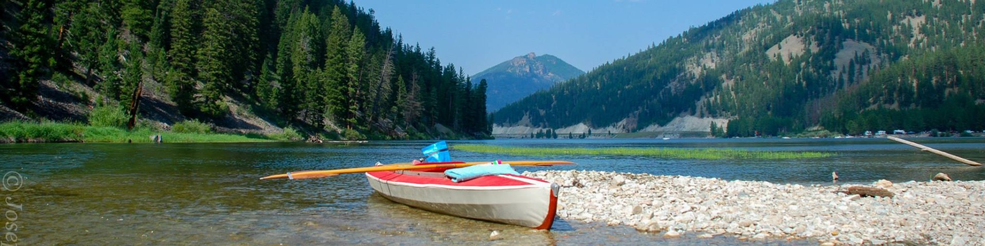
Lake Como Recreation Area provides a classic Bitterroot National Forest experience, offering opportunities for swimming, fishing, boating, hiking, mountain biking, horseback riding, and camping in a scenic mountain valley.

According to early accounts, Lost Horse Creek earned its name in 1881, when prospectors attempted to cross its swift spring runoff and one of their horses was swept away. The story spread, and the creek soon became known as “Lost Horse”—a name that has endured for generations.

The Magruder Corridor is a 95‑mile primitive road offering a rare glimpse into one of the lower 48’s most remote, undeveloped landscapes. Winding between the Bitterroot and Nez Perce–Clearwater National Forests, it provides sweeping views of the Bitterroot and Clearwater ranges and access to country that remains much as early travelers found it.
Discover the Stevensville Ranger District, set in Montana’s first permanent settlement and the northernmost part of the Bitterroot National Forest. Framed by the rolling Sapphire Mountains and the rugged Bitterroot Range, it offers access to glacial canyons, wilderness terrain, and a wide network of well‑maintained trails.

Discover the Sula Ranger District in the scenic southeast corner of the Bitterroot National Forest. Spanning more than 250,000 acres—including 41,000 within the Anaconda‑Pintler Wilderness—it offers extensive opportunities for exploration and outdoor recreation.

Experience the West Fork Ranger District, where rugged wilderness, top‑tier fishing, and memorable backcountry adventures meet. Just 18 miles south of Darby, Montana, along the scenic West Fork of the Bitterroot River, it’s a prime spot for anglers and river lovers. Spring brings fast, snowmelt‑fed flows, while summer offers calmer waters ideal for fishing and rafting.

The Continental Divide National Scenic Trail in the Bitterroot National Forest invites adventurers to explore 25 miles of high-elevation beauty along the rugged spine of th

The Bitterroot Valley played a major role in the Lewis and Clark Expedition (1804-1806), and it is one of the most meaningful stretches of their journey west.

Experience the powerful story of the 1877 Nez Perce flight as you travel the Nez Perce National Historic Trail through the breathtaking Bitterroot Valley.
Recreation
Clifford Creek Trail # 169
The Clifford Creek trail is 3.0 miles long. It begins at Trail 433 and ends at Trail 434 (Lick Creek Saddle). The trail is open for the following uses: Hiking, Horseback Riding.
Colter Creek Trail # 606
The Colter Creek trail is 3.5 miles long. It begins at Trail #673 and ends at Road #5734. The trail is open for the following uses: Horseback Riding, Motorcycle Trail Riding, and day hiking
Continental Divide NST Trail # 9
The Continental Divide NST trail is 25.0 miles long and occupies a portion of the southeast boundary between the Bitterroot and Beaverhead-Deerlodge National Forests. It begins at Chief Joseph Pass…
Cooper Point Trail # 23
The Cooper Point trail is 8.0 miles long. It begins at Trail #2 Cooper's Flat and ends at Montana State Line - Trail 699. The trail is open for the following uses: Hiking, Horseback Riding
Corral Trail
The Corral trail is 0.7 miles long. It begins at Road 715 and ends at Trail 84. The trail is open for the following uses: Motorcycle Trail Riding
Coyote Coulee Trail # 127
The Coyote Coulee Trail # 127 is 8.0 miles long loop trail that consists of two loops that total approximately 8 miles. This trail is popular with horseback riders and bicyclists.
Coyote Coulee Trailhead
Site Open
This site provides parking for passenger vehicles and horse trailers, and a vault toilet. This trailhead provides access for the Coyote Coulee loop trail system (Trail #127). This trail system is…
Crazy Creek Campground
Site Open
Crazy Creek Campground, a small campground with 7 sites, is equipped with picnic tables, fire rings, vault toilet and a hand pump for potable water. Garbage service is not provided. Pack It In/Pack…
Crazy Creek Horse Camp
Site Open
This site offers 6 horse camping sites with tables, fire rings, feed bins, hitching rails, stock water trough, and a vault toilet. Potable water is not available. Water available at Crazy Creek…
Dam Creek Trail # 88
The Dam Creek Trail # 88 is 1.2 miles long. It begins at Road # 1352 and ends at Trail # 86. The trail is open for the following uses: Horseback Riding